Category:Igreja de São Tiago (Coimbra)
| Object location | | View all coordinates using: OpenStreetMap |
|---|
church building in Coimbra, Coimbra District, Portugal .jpg) | |||||
| Upload media | |||||
| Instance of | |||||
|---|---|---|---|---|---|
| Location | São Bartolomeu, Coimbra (Sé Nova, Santa Cruz, Almedina e São Bartolomeu), Coimbra, Portugal | ||||
| Heritage designation | |||||
| Religion or worldview | |||||
 | |||||
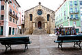
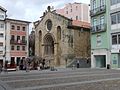
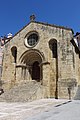
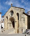
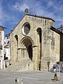
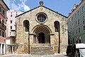
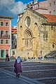
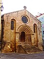
Português: Igreja de Santiago / Igreja de São Tiago / Igreja Paroquial de Santiago / Igreja de São Tiago e a demolida Igreja da Misericórdia de Coimbra. Portugal, Coimbra, Coimbra, São Bartolomeu, Praça do Comércio, faz recanto com a Rua Visconde da Luz.
|
This monument is classified as
Monumento Nacional .It is indexed in the IGESPAR database ( Instituto de Gestão do Património Arquitectónico e Arqueológico ), under the reference 69863.It is indexed in the SIPA database (Sistema de Informação para o Património Arquitectónico) under the reference 1626. |
Subcategories
This category has the following 2 subcategories, out of 2 total.
Media in category "Igreja de São Tiago (Coimbra)"
The following 42 files are in this category, out of 42 total.
-
 20200203 CoimbraOQ 5831 (49655689946).jpg 7,952 × 5,304; 25.44 MB
-
 A romanesque chapel in Coimbra (4782196746).jpg 2,048 × 1,536; 1.43 MB
-
 Coimbra (23316367120).jpg 2,816 × 2,112; 928 KB
-
 Coimbra (30337617617).jpg 2,388 × 1,791; 1.21 MB
-
 Coimbra (52100832000).jpg 5,184 × 3,888; 6.7 MB
-
 Coimbra (6088943880).jpg 1,000 × 669; 292 KB
-
 Coimbra (8125067384).jpg 2,048 × 1,536; 431 KB
-
 Coimbra (Braun – Hogenberg, 1598).jpg 1,929 × 1,224; 1.15 MB
-
 Coimbra 2021 (36).jpg 3,648 × 5,472; 8.02 MB
-
 Coimbra 2021 (37).jpg 3,648 × 5,472; 8 MB
-
 Coimbra Igreja de São Tiago BW 2018-10-06 12-48-12.jpg 5,068 × 3,976; 7.36 MB
-
 Coimbra Igreja de São Tiago BW 2018-10-06 14-11-34.jpg 3,652 × 4,238; 5.71 MB
-
 Coimbra Igreja de São Tiago BW 2018-10-06 14-11-37.jpg 3,764 × 5,020; 6.83 MB
-
 Coimbra São Tiago Weihekreuz 960.jpg 3,264 × 4,896; 21.5 MB
-
 Coimbra São Tiago Westfassade 956.jpg 3,232 × 4,848; 13.97 MB
-
 Coimbra São Tiago Westfassade 957.jpg 4,896 × 3,264; 16.37 MB
-
 Coimbra, Igreja de São Tiago.jpg 3,836 × 2,875; 2.27 MB
-
 Coimbra-38-Igreja de Santiago-2011-gje.jpg 3,456 × 4,012; 2.83 MB
-
 Coimbra-40-Igreja de Santiago-2011-gje.jpg 5,184 × 3,456; 4.25 MB
-
 Coimbra-SantiagoChurch.jpg 2,736 × 3,648; 2.29 MB
-
 Coimbra. Portugal. (53467212817).jpg 6,072 × 3,746; 14.22 MB
-
 Coimbra. Portugal. (53468254958).jpg 6,072 × 3,558; 16.13 MB
-
 Going To Church (137738973).jpeg 1,362 × 2,048; 1.04 MB
-
 Iglesia de Santiago, Coímbra, Portugal, 2012-05-10, DD 04.JPG 2,976 × 3,151; 2.35 MB
-
 Iglesia de Santiago, Coímbra, Portugal, 2012-05-10, DD 05.JPG 2,629 × 1,584; 646 KB
-
 Igr santiago 1.JPG 2,256 × 3,008; 2.56 MB
-
 Igr santiago 2.JPG 3,008 × 2,256; 2.54 MB
-
 Igr santiago 4.JPG 2,446 × 1,694; 1.23 MB
-
 Igreja de Santiago (Coimbra) - vista geral.jpg 2,112 × 2,816; 588 KB
-
 Igreja de Santiago (Coimbra).jpg 3,872 × 2,592; 4.08 MB
-
 Igreja de Santiago - Cidade de Coimbra.jpg 4,320 × 3,240; 5.48 MB
-
 Igreja de Santiago - Coimbra - Portugal (19930872579).jpg 2,592 × 3,888; 1.87 MB
-
 Igreja de Santiago - Coimbra, Portugal - DSC09624.jpg 5,472 × 3,648; 9.41 MB
-
 Igreja de Santiago - Coimbra.jpg 4,320 × 3,240; 5.73 MB
-
 Igreja de Santiago - panoramio.jpg 4,000 × 2,664; 3.18 MB
-
 Igreja de Santiago Coimbra 01.jpg 2,592 × 1,944; 1.06 MB
-
 Igreja de Santiago, Coimbra.jpg 6,000 × 4,000; 12.09 MB
-
 Igreja de São Tiago. Coimbra.jpg 2,111 × 2,814; 5.28 MB
-
 Mazda 818 DeLuxe in Portugal, pic1 at the SPECIAAL Auto Evenement Nijkerk 2011.JPG 3,225 × 2,417; 3.4 MB
-
 Portogallo 2007 (1658089727).jpg 3,648 × 2,736; 2.42 MB
-
 Portugal - DSC0557 (27792061679).jpg 4,912 × 3,264; 7.74 MB
-
 University of Coimbra - Alta and Sofia 5 (42675378565).jpg 3,888 × 5,184; 6.31 MB
.jpg)
.jpg)
.jpg)
.jpg)
.jpg)
.jpg)
.jpg)
.jpg)
.jpg)


.jpg)
.jpg)
.jpeg)


_-_vista_geral.jpg)
.jpg)

.jpg)


.jpg)
.jpg)
.jpg)