Category:Image by Seeds of life
Images by Seeds of Life. Seeds of Life (SoL) is a program within the Timor Leste Ministry of Agriculture and Fisheries (MAF). They are funded collaboratively by MAF and the Australian Government, through Australian Aid and the Australian Centre for International Agricultural Research (ACIAR). Centre for Plant Genetics and Breeding (PGB) within the University of Western Australia (UWA) is commissioned to coordinate our Australian-funded activities.
Media in category "Image by Seeds of life"
The following 200 files are in this category, out of 203 total.
(previous page) (next page)-
 Aileu Klimadiagramm.png 586 × 516; 22 KB
-
 Aileu Ricefields-001.png 4,959 × 3,509; 7.18 MB
-
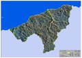
 Ailleu-TL A3 Municipality Map 110813-001.png 4,959 × 3,509; 5.61 MB
-
 Ainaro Klimadiagramm.png 586 × 518; 23 KB
-
 Ainaro Ricefields-P-001.png 3,509 × 4,959; 6.49 MB
-
 Ainaro-TL A3 District Map 110813-001.png 4,959 × 3,509; 5.7 MB
-
 Atabae Klimadiagramm.png 584 × 514; 21 KB
-
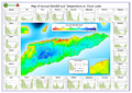
 Average annual rainfall of Timor-Leste.png 2,352 × 1,744; 1.37 MB
-
 Average annual temperature of Timor-Leste.png 2,304 × 1,664; 1.09 MB
-
 Baucau Klimadiagramm.png 588 × 516; 20 KB
-
 Baucau Ricefields-001.png 4,959 × 3,509; 5.68 MB
-
 Baucau-TL A3 District Map 110813-001.png 4,959 × 3,509; 4.01 MB
-
 Betano Klimadiagramm.png 586 × 517; 21 KB
-
 Bobonaro Ricefields-001.png 4,959 × 3,509; 5.03 MB
-
 Bobonaro-TL A3 District Map 110813-001.png 4,959 × 3,509; 4.78 MB
-
 Cova Lima Ricefields-001.png 4,959 × 3,509; 4.26 MB
-
 Cova Lima-TL A3 District Map 110813-001.png 4,959 × 3,509; 3.56 MB
-
 Dili Klimadiagramm.png 586 × 510; 19 KB
-
 Dili Ricefields-001.png 4,959 × 3,509; 3.63 MB
-
 Dili-TL A3 District Map 110813-001.png 4,959 × 3,509; 3.74 MB
-
 Ermera Ricefields-P-001.png 3,509 × 4,959; 6.71 MB
-
 Ermera-TL A3 District Map 110813-001.png 4,959 × 3,509; 5.93 MB
-
 Geology of Timor-Leste.png 2,336 × 1,728; 1.04 MB
-
 Gleno Klimadiagramm.png 589 × 513; 20 KB
-
 Hatolia Vila Klimadiagramm.png 589 × 513; 22 KB
-
 Hydrogeology of Timor-Leste, Potential aquifer yield.png 2,320 × 1,696; 846 KB
-
 Iliomar Klimadiagramm.png 589 × 513; 22 KB
-
 Lautem Ricefields-001.png 4,959 × 3,509; 4.59 MB
-
 Lautem-TL A3 District Map 110813-001.png 4,959 × 3,509; 2.48 MB
-
 Lautém Klimadiagramm.png 591 × 516; 21 KB
-
 LIFE IN PLANTS 2.jpg 4,000 × 3,000; 6.71 MB
-
 LIFE IN PLANTS.jpg 4,000 × 3,000; 6.43 MB
-
 Liquica Ricefields-001.png 4,959 × 3,509; 5.08 MB
-
 Liquica-TL A3 District Map 110813-001.png 4,959 × 3,509; 4.05 MB
-
 Liquiçá Klimadiagramm.png 586 × 512; 20 KB
-
 Lospalos Klimadiagramm.png 589 × 514; 21 KB
-
 Maliana Klimadiagramm.png 590 × 514; 22 KB
-
 Manatuto Klimadiagramm.png 588 × 514; 20 KB
-
 Manatuto Ricefields-P-001.png 3,509 × 4,959; 6.51 MB
-
 Manatuto-TL A3 District Map 110813-001.png 4,959 × 3,509; 5.17 MB
-
 Manufahi Ricefields-001.png 4,959 × 3,509; 6.42 MB
-
 Manufahi-TL A3 District Map 110813-001.png 4,959 × 3,509; 4.68 MB
-
 Maubisse Klimadiagramm.png 590 × 514; 23 KB
-
 National agro-ecological zones A3-001.png 3,508 × 2,481; 2.68 MB
-
 National Map of Fe & Zn deficiency TL A3-001.png 3,508 × 2,481; 3.48 MB
-
 National Map of Soil pH A3-001.png 3,508 × 2,481; 3.02 MB
-
 National Map of Soil Texture A3-001.png 3,508 × 2,481; 3.23 MB
-
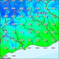
 National rainfall map with graphs 2012 A3-001.png 4,961 × 3,508; 4.34 MB
-
 National ricefields A3-001.png 4,959 × 3,506; 1.16 MB
-
 Oecusse Ricefields-001.png 4,959 × 3,509; 2.67 MB
-
 Oecusse-TL A3 District Map 110813-001.png 4,959 × 3,509; 2.5 MB
-
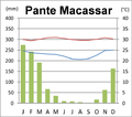 Pante Macassar Klimadiagramm.png 586 × 517; 30 KB
-
 Rain 2000 AILEU VILA.jpg 968 × 968; 180 KB
-
 Rain 2000 AINARO.jpg 968 × 968; 187 KB
-
 Rain 2000 ALAS.jpg 968 × 968; 166 KB
-
 Rain 2000 ATABAE.jpg 968 × 968; 134 KB
-
 Rain 2000 ATAURO.jpg 968 × 968; 86 KB
-
 Rain 2000 ATSABE.jpg 968 × 968; 167 KB
-
 Rain 2000 BAGUIA.jpg 968 × 968; 171 KB
-
 Rain 2000 BALIBO.jpg 968 × 968; 127 KB
-
 Rain 2000 BAUCAU.jpg 968 × 968; 161 KB
-
 Rain 2000 BAZARTETE.jpg 968 × 968; 153 KB
-
 Rain 2000 BOBONARO.jpg 968 × 968; 189 KB
-
 Rain 2000 CAILACO.jpg 968 × 968; 168 KB
-
 Rain 2000 CRISTO REI.jpg 968 × 968; 79 KB
-
 Rain 2000 DOM ALEIXO.jpg 968 × 968; 82 KB
-
 Rain 2000 ERMERA.jpg 968 × 968; 129 KB
-
 Rain 2000 FATUBERLIO.jpg 968 × 968; 220 KB
-
 Rain 2000 FATULULIC.jpg 968 × 968; 79 KB
-
 Rain 2000 FATUMEAN.jpg 968 × 968; 102 KB
-
 Rain 2000 FOHOREM.jpg 968 × 968; 112 KB
-
 Rain 2000 HATO-UDO.jpg 968 × 968; 141 KB
-
 Rain 2000 HATU-BUILICO.jpg 968 × 968; 127 KB
-
 Rain 2000 HATULIA.jpg 968 × 968; 177 KB
-
 Rain 2000 ILIOMAR.jpg 968 × 968; 130 KB
-
 Rain 2000 JACO (TUTUALA).jpg 968 × 968; 45 KB
-
 Rain 2000 LACLO.jpg 968 × 968; 164 KB
-
 Rain 2000 LACLUBAR.jpg 968 × 968; 186 KB
-
 Rain 2000 LACLUTA.jpg 968 × 968; 170 KB
-
 Rain 2000 LAGA.jpg 968 × 968; 144 KB
-
 Rain 2000 LALEIA.jpg 968 × 968; 134 KB
-
 Rain 2000 LAULARA.jpg 968 × 968; 157 KB
-
 Rain 2000 LAUTEM.jpg 968 × 968; 193 KB
-
 Rain 2000 LEQUIDOE.jpg 968 × 968; 155 KB
-
 Rain 2000 LETEFOHO.jpg 968 × 968; 131 KB
-
 Rain 2000 LIQUICA.jpg 968 × 968; 129 KB
-
 Rain 2000 LOLOTOE.jpg 968 × 968; 146 KB
-
 Rain 2000 LOSPALOS.jpg 968 × 968; 149 KB
-
 Rain 2000 LURO.jpg 968 × 968; 110 KB
-
 Rain 2000 MALIANA.jpg 968 × 968; 150 KB
-
 Rain 2000 MANATUTO.jpg 968 × 968; 166 KB
-
 Rain 2000 MAUBARA.jpg 968 × 968; 132 KB
-
 Rain 2000 MAUBISSE.jpg 968 × 968; 170 KB
-
 Rain 2000 MAUCATAR.jpg 968 × 968; 122 KB
-
 Rain 2000 NAIN FETO.jpg 968 × 968; 94 KB
-
 Rain 2000 NITIBE.jpg 968 × 968; 134 KB
-
 Rain 2000 OESILO.jpg 968 × 968; 97 KB
-
 Rain 2000 OSSU.jpg 968 × 968; 181 KB
-
 Rain 2000 PANTE MACASSAR.jpg 968 × 968; 136 KB
-
 Rain 2000 PASSABE.jpg 968 × 968; 73 KB
-
 Rain 2000 QUELICAI.jpg 968 × 968; 150 KB
-
 Rain 2000 RAILACO.jpg 968 × 968; 145 KB
-
 Rain 2000 REMEXIO.jpg 968 × 968; 154 KB
-
 Rain 2000 SAME.jpg 968 × 968; 196 KB
-
 Rain 2000 SOIBADA.jpg 968 × 968; 131 KB
-
 Rain 2000 SUAI.jpg 968 × 968; 170 KB
-
 Rain 2000 TILOMAR.jpg 968 × 968; 109 KB
-
 Rain 2000 TURISCAI.jpg 968 × 968; 139 KB
-
 Rain 2000 UATO-LARI.jpg 968 × 968; 131 KB
-
 Rain 2000 UATUCARBAU.jpg 968 × 968; 107 KB
-
 Rain 2000 VEMASSE.jpg 968 × 968; 155 KB
-
 Rain 2000 VENILALE.jpg 968 × 968; 131 KB
-
 Rain 2000 VERA CRUZ.jpg 968 × 968; 112 KB
-
 Rain 2000 VIQUEQUE.jpg 968 × 968; 214 KB
-
 Rain 2000 ZUMALAI.jpg 968 × 968; 170 KB
-
 Recharge of Timor-Leste.png 2,288 × 1,776; 2.36 MB
-
 Remexio Klimadiagramm.png 582 × 512; 22 KB
-
 Same Klimadiagramm.png 587 × 517; 24 KB
-
 Soibada Klimadiagramm.png 583 × 516; 23 KB
-
 Soil types of Timor-Leste.png 2,388 × 1,761; 1.15 MB
-
 Suai Klimadiagramm.png 587 × 516; 21 KB
-
 Temperature 2000 AILEU VILA.jpg 968 × 968; 172 KB
-
 Temperature 2000 AINARO.jpg 968 × 968; 165 KB
-
 Temperature 2000 ALAS.jpg 968 × 968; 148 KB
-
 Temperature 2000 ATABAE.jpg 968 × 968; 119 KB
-
 Temperature 2000 ATAURO.jpg 968 × 968; 80 KB
-
 Temperature 2000 ATSABE.jpg 968 × 968; 157 KB
-
 Temperature 2000 BAGUIA.jpg 968 × 968; 160 KB
-
 Temperature 2000 BALIBO.jpg 968 × 968; 112 KB
-
 Temperature 2000 BAUCAU.jpg 968 × 968; 149 KB
-
 Temperature 2000 BAZARTETE.jpg 968 × 968; 142 KB
-
 Temperature 2000 BOBONARO.jpg 968 × 968; 173 KB
-
 Temperature 2000 CAILACO.jpg 968 × 968; 156 KB
-
 Temperature 2000 CRISTO REI.jpg 968 × 968; 75 KB
-
 Temperature 2000 DOM ALEIXO.jpg 968 × 968; 74 KB
-
 Temperature 2000 ERMERA.jpg 968 × 968; 124 KB
-
 Temperature 2000 FATUBERLIO.jpg 968 × 968; 198 KB
-
 Temperature 2000 FATULULIC.jpg 968 × 968; 78 KB
-
 Temperature 2000 FATUMEAN.jpg 968 × 968; 100 KB
-
 Temperature 2000 FOHOREM.jpg 968 × 968; 108 KB
-
 Temperature 2000 HATO-UDO.jpg 968 × 968; 121 KB
-
 Temperature 2000 HATU-BUILICO.jpg 968 × 968; 116 KB
-
 Temperature 2000 HATULIA.jpg 968 × 968; 161 KB
-
 Temperature 2000 ILIOMAR.jpg 968 × 968; 128 KB
-
 Temperature 2000 JACO, TUTUALA.jpg 968 × 968; 45 KB
-
 Temperature 2000 LACLO.jpg 968 × 968; 145 KB
-
 Temperature 2000 LACLUBAR.jpg 968 × 968; 172 KB
-
 Temperature 2000 LACLUTA.jpg 968 × 968; 161 KB
-
 Temperature 2000 LAGA.jpg 968 × 968; 133 KB
-
 Temperature 2000 LALEIA.jpg 968 × 968; 118 KB
-
 Temperature 2000 LAULARA.jpg 968 × 968; 149 KB
-
 Temperature 2000 LAUTEM.jpg 968 × 968; 189 KB
-
 Temperature 2000 LEQUIDOE.jpg 968 × 968; 146 KB
-
 Temperature 2000 LETEFOHO.jpg 968 × 968; 122 KB
-
 Temperature 2000 LIQUICA.jpg 968 × 968; 117 KB
-
 Temperature 2000 LOLOTOE.jpg 968 × 968; 139 KB
-
 Temperature 2000 LOSPALOS.jpg 968 × 968; 150 KB
-
 Temperature 2000 LURO.jpg 968 × 968; 110 KB
-
 Temperature 2000 MALIANA.jpg 968 × 968; 144 KB
-
 Temperature 2000 MANATUTO.jpg 968 × 968; 142 KB
-
 Temperature 2000 MAUBARA.jpg 968 × 968; 117 KB
-
 Temperature 2000 MAUBISSE.jpg 968 × 968; 156 KB
-
 Temperature 2000 MAUCATAR.jpg 968 × 968; 114 KB
-
 Temperature 2000 NAIN FETO.jpg 968 × 968; 88 KB
-
 Temperature 2000 NITIBE.jpg 968 × 968; 131 KB
-
 Temperature 2000 OESILO.jpg 968 × 968; 96 KB
-
 Temperature 2000 OSSU.jpg 968 × 968; 172 KB
-
 Temperature 2000 PANTE MACASSAR.jpg 968 × 968; 131 KB
-
 Temperature 2000 PASSABE.jpg 968 × 968; 74 KB
-
 Temperature 2000 QUELICAI.jpg 968 × 968; 139 KB
-
 Temperature 2000 RAILACO.jpg 968 × 968; 135 KB
-
 Temperature 2000 REMEXIO.jpg 968 × 968; 141 KB
-
 Temperature 2000 SAME.jpg 968 × 968; 171 KB
-
 Temperature 2000 SOIBADA.jpg 968 × 968; 118 KB
-
 Temperature 2000 SUAI.jpg 968 × 968; 162 KB
-
 Temperature 2000 TILOMAR.jpg 968 × 968; 101 KB
-
 Temperature 2000 TURISCAI.jpg 968 × 968; 132 KB
-
 Temperature 2000 UATO-LARI.jpg 968 × 968; 126 KB
-
 Temperature 2000 UATUCARBAU.jpg 968 × 968; 103 KB
-
 Temperature 2000 VEMASSE.jpg 968 × 968; 140 KB
-
 Temperature 2000 VENILALE.jpg 968 × 968; 124 KB
-
 Temperature 2000 VERA CRUZ.jpg 968 × 968; 104 KB
-
 Temperature 2000 VIQUEQUE.jpg 968 × 968; 208 KB
-
 Temperature 2000 ZUMALAI.jpg 968 × 968; 159 KB
-
 TL A0 HShade 101113-001.png 14,044 × 9,934; 18.97 MB
-
 TL A3 Admin Map 112113-001.png 14,044 × 9,934; 7.05 MB
-
 TL A3 Admin Map 112213-001.png 4,959 × 3,509; 2.72 MB
-
 TL A3 Water Body 112113-001.png 14,044 × 9,934; 5.47 MB
-
 TL-Admin Map A4 111313-001.png 3,509 × 2,481; 630 KB
-
 TL-AEZ Map A4 111313-001.png 3,509 × 2,481; 939 KB
-
 TL-Hydrogeological map-001 Main map.jpg 8,172 × 3,951; 4.48 MB
-
 TL-Hydrogeological map-001.png 16,772 × 10,169; 18.92 MB
-
 TL-Land Cover Map A4 111313-001.png 3,509 × 2,481; 811 KB
-
 TL-Road Map A4 111313-001.png 3,509 × 2,481; 765 KB
-
 TL-Slope Map A4 111313-001.png 3,509 × 2,481; 678 KB
-
 TL-Watershed Map A4 111313-001.png 3,509 × 2,481; 794 KB
-
 Topography of Timor-Leste.png 2,272 × 1,744; 2.43 MB
-
 Uma Boco Klimadiagramm.png 587 × 518; 26 KB
-
 Vemasse Klimadiagramm.png 584 × 515; 21 KB
-
 Venilale Klimadiagramm.png 587 × 509; 21 KB


.jpg)


