Category:Images by John Rostron

Media in category "Images by John Rostron"
The following 200 files are in this category, out of 677 total.
(previous page) (next page)-

-
 'Access Land' sign on cliff walk - geograph.org.uk - 1505495.jpg 640 × 480; 145 KB
-
 Abbey Gardens, Tresco, Scilly - geograph.org.uk - 1606637.jpg 480 × 640; 165 KB
-

-

-

-

-
-

-
-

-

-

-

-

-

-

-

-

-

-

-
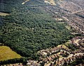
 Aerial view of Coombe Wood, Benfleet - geograph.org.uk - 1635623.jpg 640 × 511; 182 KB
-

-
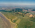
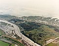
 Aerial view of Crouch Estuary - geograph.org.uk - 1420592.jpg 640 × 425; 78 KB
-

-

-

-

-

-

-

-

-

-
-
-

-

-
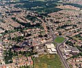
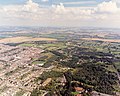
 Aerial view of Hadleigh town centre - geograph.org.uk - 1656993.jpg 640 × 511; 206 KB
-

-

-

-
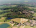
 Aerial view of Hurst Farm and Tile Wood - geograph.org.uk - 1580053.jpg 640 × 510; 175 KB
-

-

-

-

-

-

-

-

-

-
-

-

-

-

-

-
 Aerial view of Old Leigh in the snow - geograph.org.uk - 1563688.jpg 640 × 502; 245 KB
-

-
-
 Aerial view of Pound Wood nature reserve - geograph.org.uk - 1535798.jpg 640 × 452; 159 KB
-

-

-

-
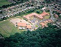
 Aerial view of SEEVIC, Benfleet - geograph.org.uk - 1574012.jpg 640 × 510; 314 KB
-
-

-

-

-
 Aerial view of South Benfleet suburbia - geograph.org.uk - 1623832.jpg 640 × 492; 191 KB
-

-
 Aerial view of south-western Benfleet - geograph.org.uk - 1656290.jpg 640 × 502; 183 KB
-

-
-

-
-

-
-

-
-

-

-

-

-

-

-

-

-

-

-
-

-
-

-

-

-

-
-

-

-
-

-

-

-

-

-

-
-

-

-
-

-

-

-

-
-
-

-
-
-

-

-
 Aerial view of Two-Tree Island, eastern half - geograph.org.uk - 1565159.jpg 5,970 × 4,679; 4.55 MB
-
 Aerial view of Two-Tree Island, eastern tip - geograph.org.uk - 1565141.jpg 5,970 × 4,719; 5 MB
-

-
 Aerial view of west Hadleigh - geograph.org.uk - 1594271.jpg 640 × 508; 174 KB
-

-
-

-

-

-
 Aircraft landing over allotments - geograph.org.uk - 1510792.jpg 640 × 317; 85 KB
-
-

-
 Appletree Bay and Carn Near, Tresco - geograph.org.uk - 1434922.jpg 640 × 480; 133 KB
-
 Approaching Men-a-vaur from the east - geograph.org.uk - 1406629.jpg 640 × 453; 82 KB
-
 Askival from Loch Coire nan Grunnd - geograph.org.uk - 1470803.jpg 487 × 640; 173 KB
-
 Babbington's Leek, Tresco, Scilly - geograph.org.uk - 1606659.jpg 640 × 480; 109 KB
-

-
 Bandstand at Vale Park, New Brighton - geograph.org.uk - 1742222.jpg 640 × 357; 117 KB
-
 Bar Point Beach, St Mary's, Scilly - geograph.org.uk - 1600087.jpg 640 × 471; 75 KB
-
 Barking Barrier from Upstream - geograph.org.uk - 1481962.jpg 640 × 436; 112 KB
-
 Beach huts and boats, Kingsdown beach - geograph.org.uk - 1503480.jpg 640 × 467; 198 KB
-
 Beach on Samson, Isles of Scilly - geograph.org.uk - 1615422.jpg 640 × 303; 54 KB
-
 Beckton STP Comminutor Gates 1991 - geograph.org.uk - 1481871.jpg 499 × 640; 159 KB
-
 Beckton STP, Activated Sludge Tank - geograph.org.uk - 1481906.jpg 494 × 640; 167 KB
-

-

-

-
 Beckton STP, Primary Settling Tank - geograph.org.uk - 1481890.jpg 640 × 428; 154 KB
-
 Beckton STP, Secondary Settling Tank - geograph.org.uk - 1481916.jpg 640 × 413; 111 KB
-
 Beckton STP, Sludge Digestion Tank - geograph.org.uk - 1481947.jpg 640 × 419; 99 KB
-

-
 Benfleet Baptist Church - geograph.org.uk - 1600414.jpg 640 × 480; 130 KB
-
 Benfleet High Road on to the Station - geograph.org.uk - 1569278.jpg 640 × 401; 156 KB
-

-

-

-
 Benfleet station and bus stops - geograph.org.uk - 1524220.jpg 640 × 480; 147 KB
-
 Benfleet station car park - geograph.org.uk - 1586430.jpg 632 × 369; 79 KB
-

-
 Big Al's Furniture Kingdom - geograph.org.uk - 1525575.jpg 640 × 480; 196 KB
-

-

-
 Blowhole near The Basin, Skomer - geograph.org.uk - 1479822.jpg 422 × 640; 139 KB
-

-
-

-
 Bosky Pine Trees at Porth Hellick - geograph.org.uk - 1617218.jpg 640 × 480; 198 KB
-

-

-
 Braunton Burrows from Instow - geograph.org.uk - 1420605.jpg 640 × 295; 53 KB
-

-

-
 Brownsea Island and Poole Harbour - geograph.org.uk - 1590912.jpg 640 × 418; 88 KB
-
-
 Burhou from above Clonque Bay.jpg 640 × 480; 93 KB
-
 Bus stop by Benfleet station - geograph.org.uk - 1524232.jpg 640 × 480; 145 KB
-
 Butcher's Broom in suburbia - geograph.org.uk - 1562494.jpg 640 × 480; 277 KB
-
 C2C train approaching Benfleet station - geograph.org.uk - 1524227.jpg 640 × 480; 147 KB
-
 Campsite by Loch Scresort, Rum - geograph.org.uk - 1440638.jpg 640 × 426; 226 KB
-
 Canna and Sanday from Kilmory, Rum - geograph.org.uk - 1438062.jpg 640 × 335; 76 KB
-
 Canvey Island Outpatients Clinic - geograph.org.uk - 1594677.jpg 640 × 508; 86 KB
-
 Car Park at Aber Ogwen - geograph.org.uk - 1464532.jpg 640 × 480; 140 KB
-
 Castle Down, North Tresco, Scilly - geograph.org.uk - 1618470.jpg 640 × 451; 90 KB
-
 Causeway to Chapel Rock, Marazion - geograph.org.uk - 1777682.jpg 500 × 640; 116 KB
-
 Cautley Holme Beck footbridge - geograph.org.uk - 1620782.jpg 640 × 419; 131 KB
-
 Cautley Spout and the Holme Beck valley - geograph.org.uk - 1431569.jpg 403 × 600; 162 KB
-
 Chalkwell paddling pool and beach - geograph.org.uk - 1740622.jpg 640 × 353; 80 KB
-

-
 Channels in the Dengie saltmarsh - geograph.org.uk - 1434313.jpg 640 × 422; 112 KB
-
 Charcoal Kiln in Pound Wood - geograph.org.uk - 1577749.jpg 640 × 427; 166 KB
-
 Cheddar Gorge and cliffs - geograph.org.uk - 1512222.jpg 530 × 640; 113 KB
-

-

-
 China clay spoil heaps in the eighties - geograph.org.uk - 1512216.jpg 640 × 425; 134 KB
-
 China clay spoil heaps in the eighties - geograph.org.uk - 1512218.jpg 421 × 640; 184 KB
-
 Cleansing reedbed at Chester Zoo - geograph.org.uk - 1658217.jpg 640 × 421; 151 KB
-

-
 Cliff and path below Bodlondeb Woods - geograph.org.uk - 1466457.jpg 640 × 480; 270 KB


_-_geograph.org.uk_-_1770279.jpg)


.jpg)


_-_geograph.org.uk_-_1510576.jpg)


