Category:Images by Kev Griffin

Media in category "Images by Kev Griffin"
The following 200 files are in this category, out of 689 total.
(previous page) (next page)-

-
 "Temporary" Footpath Closure ^ - geograph.org.uk - 1512849.jpg 640 × 480; 101 KB
-
 A470 North, Pentrebach - geograph.org.uk - 421685.jpg 640 × 480; 61 KB
-
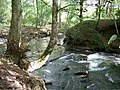
 Afon Mellte, Ystradfellte - geograph.org.uk - 886304.jpg 640 × 480; 357 KB
-

-

-
 Aircraft Over The Bulwarks - geograph.org.uk - 1366757.jpg 640 × 480; 207 KB
-
 Airport Approach Lights at The Bulwarks - geograph.org.uk - 1366764.jpg 640 × 461; 199 KB
-
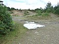
 Ancient Flying Saucer buried at Cwm Nash - geograph.org.uk - 1324110.jpg 2,848 × 2,136; 4.06 MB
-

-

-

-

-

-
 Bargoed, High Street.jpg 640 × 480; 79 KB
-

-
 Base of Mynydd Moelgeila, Garw Forest - geograph.org.uk - 985724.jpg 480 × 640; 382 KB
-
 Beaufort Hill Woodland - N.E.Entrance - geograph.org.uk - 579094.jpg 480 × 640; 100 KB
-
-

-

-
-

-
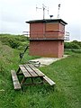
 Beaufort Hill Woodlands Reservoir - geograph.org.uk - 579103.jpg 640 × 370; 73 KB
-
 Beaufort Hill Woodlands, Eastern Entrance - geograph.org.uk - 579101.jpg 640 × 480; 122 KB
-
 Beaufort Street Car Park, Brynmawr - geograph.org.uk - 365544.jpg 640 × 480; 91 KB
-
 Beaufort Street, Brynmawr - geograph.org.uk - 365541.jpg 640 × 480; 91 KB
-
 Bedwas to Machen Cycleway - geograph.org.uk - 1205697.jpg 640 × 480; 106 KB
-
 Bedwas to Machen Cycleway - geograph.org.uk - 1205710.jpg 640 × 480; 99 KB
-
 Bedwas to Machen Cycleway - geograph.org.uk - 1205713.jpg 640 × 480; 121 KB
-
 Bedwas to Machen Cycleway - geograph.org.uk - 1205722.jpg 480 × 640; 141 KB
-
 Bedwas to Machen Cycleway - geograph.org.uk - 1205777.jpg 640 × 480; 118 KB
-
 Bedwas to Machen Cycleway - geograph.org.uk - 1205783.jpg 480 × 640; 100 KB
-
 Bedwas to Machen Cycleway - geograph.org.uk - 1205797.jpg 640 × 480; 112 KB
-
 Bedwas to Machen Cycleway - geograph.org.uk - 1205803.jpg 640 × 480; 131 KB
-

-

-
 Bethcar Street, Ebbw Vale - geograph.org.uk - 366368.jpg 640 × 480; 89 KB
-
 Bethcar Street, Ebbw Vale - geograph.org.uk - 366369.jpg 640 × 480; 88 KB
-

-

-
 Birds of a Feather - geograph.org.uk - 985721.jpg 480 × 640; 403 KB
-
 Black Lambs at Craig-y-Rhacca Farm - geograph.org.uk - 1205877.jpg 640 × 515; 148 KB
-
 Blackwood Retail Park, Blackwood - geograph.org.uk - 363986.jpg 640 × 480; 64 KB
-
 Blackwood Retail Park, Blackwood - geograph.org.uk - 363987.jpg 640 × 480; 69 KB
-
 Blaen-Llech - geograph.org.uk - 932033.jpg 640 × 640; 359 KB
-
 Blaen-Y-Cwm Nature Reserve Entrance - geograph.org.uk - 1323243.jpg 640 × 480; 145 KB
-
 Blaenavon Ironworks - Main Gate - geograph.org.uk - 579027.jpg 640 × 480; 116 KB
-
 Blaenavon Ironworks - North East Fence - geograph.org.uk - 579023.jpg 480 × 640; 101 KB
-
 Blaenavon Ironworks Car Park - geograph.org.uk - 579014.jpg 640 × 480; 99 KB
-
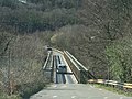
 Bridge over the Bay - geograph.org.uk - 1512856.jpg 640 × 480; 100 KB
-
-
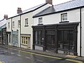 Broad Street, Blaenavon - geograph.org.uk - 358082.jpg 640 × 480; 65 KB
-
 Bryngarw Country Park, Brynmenyn - geograph.org.uk - 568314.jpg 480 × 640; 125 KB
-
 Bryngarw Country Park, Brynmenyn - geograph.org.uk - 568317.jpg 640 × 480; 339 KB
-
 Bryngarw Country Park, Brynmenyn - geograph.org.uk - 568319.jpg 480 × 640; 339 KB
-
 Bryngarw Country Park, Brynmenyn - geograph.org.uk - 568324.jpg 639 × 640; 191 KB
-
 Bryngarw Country Park, Brynmenyn - geograph.org.uk - 568325.jpg 640 × 480; 373 KB
-

-
 Caerphilly Common - Taff Ely Ridgway Walk - geograph.org.uk - 571013.jpg 640 × 480; 114 KB
-
 Caerphilly Common - Waypoint Marker - geograph.org.uk - 571010.jpg 640 × 480; 110 KB
-
 Caerphilly Mountain - geograph.org.uk - 434324.jpg 640 × 480; 119 KB
-
 Caerphilly Mountain - geograph.org.uk - 434346.jpg 640 × 480; 125 KB
-
 Caerphilly Mountain - geograph.org.uk - 434362.jpg 640 × 480; 126 KB
-
 Caerphilly Tunnel Air Shaft No.3. - geograph.org.uk - 457512.jpg 480 × 640; 359 KB
-
 Caerphilly Tunnel Air Shaft No.4. - geograph.org.uk - 457520.jpg 640 × 480; 349 KB
-
 Caisson off Breaksea Point - geograph.org.uk - 1366951.jpg 640 × 480; 52 KB
-
 Callaghan Square - geograph.org.uk - 357737.jpg 640 × 427; 62 KB
-
-

-
 Cardiff Gate Business Park, Cardiff - geograph.org.uk - 370685.jpg 640 × 480; 108 KB
-

-
 Carn Cornel Site, Hirfynydd - geograph.org.uk - 975842.jpg 640 × 480; 404 KB
-
 Carn Foesen - geograph.org.uk - 1000730.jpg 640 × 480; 293 KB
-
 Castell Coch View, Tongwynlais - geograph.org.uk - 424425.jpg 640 × 480; 80 KB
-
 Castell Talyfan Footpath - geograph.org.uk - 490799.jpg 640 × 480; 303 KB
-
 Castleton Court, St Mellons - geograph.org.uk - 370701.jpg 640 × 480; 95 KB
-
 Catherine Street Car Park, Pontypridd - geograph.org.uk - 362691.jpg 640 × 479; 71 KB
-
 Cattle Grid, Coed y Rhaiadr - geograph.org.uk - 917452.jpg 480 × 640; 368 KB
-
 Cefn Onn Quarry in evening light - geograph.org.uk - 457508.jpg 640 × 480; 280 KB
-

-
-

-
 Celtic Springs Business Park, Newport - geograph.org.uk - 358046.jpg 640 × 480; 103 KB
-
 Celtic Springs Business Park, Newport - geograph.org.uk - 358050.jpg 640 × 480; 63 KB
-
 Celtic Springs Business Park, Newport - geograph.org.uk - 358057.jpg 640 × 480; 65 KB
-
 Cerdded Bro Nedd, Sarn Helen Roman Road - geograph.org.uk - 975911.jpg 640 × 480; 264 KB
-
 Cerdded Bro Nedd, Sarn Helen Roman Road - geograph.org.uk - 975915.jpg 640 × 480; 317 KB
-
 Cerdded Bro Nedd, Sarn Helen Roman Road - geograph.org.uk - 975922.jpg 480 × 640; 311 KB
-
 Cerdded Bro Nedd, Sarn Helen Roman Road - geograph.org.uk - 975930.jpg 640 × 480; 291 KB
-
 Cherry Orchard Road, Thornhill - geograph.org.uk - 410342.jpg 640 × 479; 104 KB
-
 Clarence Hotel, Pontypool - geograph.org.uk - 357794.jpg 640 × 480; 196 KB
-

-
 Clawdd-coch1.jpg 2,816 × 2,112; 2.37 MB
-
 Clawdd-coch3.jpg 640 × 480; 185 KB
-
 Cliff at Cwm Nash - geograph.org.uk - 1297897.jpg 480 × 640; 73 KB
-
 Climb to Nant Berw Wion Waterfall - geograph.org.uk - 1004297.jpg 640 × 640; 516 KB
-
 Climb to Nant Berw Wion Waterfall - geograph.org.uk - 1004302.jpg 518 × 640; 436 KB
-
 Close to the Edge, Overton Cliff Pathway - geograph.org.uk - 1521165.jpg 480 × 640; 118 KB
-

-
 Coastal Path and Tidal Defence Wall - geograph.org.uk - 1366962.jpg 640 × 470; 82 KB
-
 Coastal Path Footbridge - geograph.org.uk - 1366809.jpg 640 × 480; 115 KB
-
 Coastal Path, Port Eynon Bay - geograph.org.uk - 1512816.jpg 640 × 632; 105 KB
-
 Coastline approaching Blackhole Gut - geograph.org.uk - 1521103.jpg 640 × 480; 97 KB
-
 Coed y Rhaiadr - geograph.org.uk - 917360.jpg 480 × 640; 409 KB
-
 Coed y Rhaiadr - geograph.org.uk - 917379.jpg 640 × 480; 292 KB
-
 Coed y Rhaiadr - geograph.org.uk - 917396.jpg 640 × 480; 333 KB
-
 Coed y Wenallt Forestry Walk - Car Park - geograph.org.uk - 439768.jpg 640 × 480; 107 KB
-
 Coity Tip Trail, Information Point - geograph.org.uk - 579053.jpg 640 × 480; 92 KB
-

-
 Coity Tip Trail, Swing Gate - geograph.org.uk - 579059.jpg 480 × 640; 129 KB
-

-
 Construction Site, Rear of Hanbury Road - geograph.org.uk - 868051.jpg 640 × 480; 312 KB
-

-

-
 Country Road South of Llansannor - geograph.org.uk - 491574.jpg 640 × 480; 322 KB
-
 Covered Reservoir near Cefngwaunhnog - geograph.org.uk - 917455.jpg 640 × 480; 288 KB
-
 Craig-y-Rhacca Farmyard - geograph.org.uk - 1205870.jpg 640 × 640; 138 KB
-
 Crane Street, Pontypool - geograph.org.uk - 357787.jpg 640 × 480; 98 KB
-
 Crane Street, Pontypool - geograph.org.uk - 357790.jpg 640 × 480; 74 KB
-

-
 Crossways Retail Park, Caerphilly - geograph.org.uk - 372628.jpg 640 × 480; 68 KB
-
 Crossways Retail Park, Caerphilly - geograph.org.uk - 372635.jpg 640 × 480; 100 KB
-
 Crynant Forestry Walk - geograph.org.uk - 960060.jpg 640 × 480; 296 KB
-
 Crynant Forestry Walk - geograph.org.uk - 960069.jpg 640 × 480; 290 KB
-
 Crynant Forestry Walk - geograph.org.uk - 963619.jpg 640 × 480; 142 KB
-
 Crynant Forestry Walk - geograph.org.uk - 963625.jpg 640 × 480; 148 KB
-
 Crynant Forestry Walk - geograph.org.uk - 963632.jpg 640 × 480; 140 KB
-
 Crynant Forestry Walk - geograph.org.uk - 963643.jpg 640 × 480; 142 KB
-
 Crynant Forestry Walk - geograph.org.uk - 963654.jpg 640 × 480; 124 KB
-
 Crynant Forestry Walk - geograph.org.uk - 963658.jpg 640 × 480; 100 KB
-
 Crynant Forestry Walk - geograph.org.uk - 963668.jpg 640 × 480; 128 KB
-
 Crynant Forestry Walk - geograph.org.uk - 963670.jpg 640 × 480; 118 KB
-
 Crynant Forestry Walk - geograph.org.uk - 963674.jpg 640 × 480; 143 KB
-
 Crynant Forestry Walk - geograph.org.uk - 963677.jpg 640 × 480; 127 KB
-
 Crynant Forestry Walk - geograph.org.uk - 963698.jpg 640 × 480; 121 KB
-
 Crynant Forestry Walk - geograph.org.uk - 963701.jpg 640 × 480; 121 KB
-
 Crynant Forestry Walk - geograph.org.uk - 963719.jpg 640 × 480; 74 KB
-
 Crynant Forestry Walk - geograph.org.uk - 963827.jpg 640 × 480; 137 KB
-
 Crynant Forestry Walk - geograph.org.uk - 963846.jpg 640 × 480; 116 KB
-
 Crynant Forestry Walk Entrance - geograph.org.uk - 975964.jpg 639 × 480; 284 KB
-
 Crynant Forestry Walk, Hirfynydd - geograph.org.uk - 963731.jpg 640 × 480; 115 KB
-
 Crynant Forestry Walk, Hirfynydd - geograph.org.uk - 963822.jpg 640 × 480; 134 KB
-
 Crynant Forestry Walk, Picnic Site - geograph.org.uk - 975968.jpg 640 × 480; 327 KB
-
 Cwm Footbridge, Ebbw Vale - geograph.org.uk - 373512.jpg 640 × 480; 64 KB
-
 Cwm Footbridge, Ebbw Vale - geograph.org.uk - 373516.jpg 640 × 480; 74 KB
-
 Cwm Lluest Log, Stardate 2007.10 - geograph.org.uk - 1004414.jpg 640 × 480; 310 KB
-
 Cwm-Leyshon Quarry - Disused - geograph.org.uk - 438922.jpg 640 × 480; 120 KB
-
 Cwmnofydd Lane, Machen Forge Trail - geograph.org.uk - 1238266.jpg 640 × 480; 127 KB
-
 Cwmtillery Industrial Estate - geograph.org.uk - 363965.jpg 640 × 480; 97 KB
-
 Dead Tree overlooking Waterloo. - geograph.org.uk - 1205768.jpg 480 × 640; 92 KB
-
-

-

-
 Derelict Farm Building, Caercady - geograph.org.uk - 481665.jpg 640 × 480; 328 KB
-

-
 Disused Quarry at Font-y-gari - geograph.org.uk - 1366837.jpg 640 × 474; 99 KB
-
 Disused Quarry, Hirfynydd - geograph.org.uk - 963753.jpg 640 × 480; 104 KB
-

-
 Dowlais Top Reservoir, Merthyr Tydfil - geograph.org.uk - 578859.jpg 640 × 640; 146 KB
-
 Dowlais Top Reservoir, Merthyr Tydfil - geograph.org.uk - 578868.jpg 432 × 640; 215 KB
-

-
 Dunlop Semtex Site, Brynmawr - geograph.org.uk - 365566.jpg 640 × 480; 69 KB
-
 Dunraven Place, Bridgend - geograph.org.uk - 358837.jpg 640 × 480; 57 KB
-

-

-
 Ebbw Vale Car Park - geograph.org.uk - 366360.jpg 640 × 426; 67 KB
-

-
 Environmental Improvements at Markham - geograph.org.uk - 578962.jpg 640 × 480; 347 KB
-

-

-
 EWS Diesel Locomotive 66162 - geograph.org.uk - 1366853.jpg 640 × 511; 95 KB
-
 Excalibur Drive, Thornhill - geograph.org.uk - 410420.jpg 640 × 480; 217 KB
-
 Face of Stone, Sarn Helen Roman Road - geograph.org.uk - 975953.jpg 640 × 480; 412 KB
-
 Field of Buttercups at Marcross - geograph.org.uk - 1324120.jpg 640 × 480; 114 KB
-
 Flotsam and Jetsam near Penry Bay - geograph.org.uk - 1366992.jpg 640 × 480; 107 KB
-
 Flowers at Dams Bay - geograph.org.uk - 1366774.jpg 480 × 640; 128 KB
-
 Fontygari Bay - geograph.org.uk - 1366847.jpg 640 × 474; 117 KB
-

-

-

-

-

-
 Footbridge over Stream at Cwm Nash - geograph.org.uk - 1297886.jpg 640 × 480; 106 KB
-

-
 Footpath at Cwm Lluest - geograph.org.uk - 1004402.jpg 640 × 480; 344 KB
-
 Footpath at Mynydd Blaenrhondda - geograph.org.uk - 1000663.jpg 640 × 480; 275 KB
-
 Footpath at Rhoose Point - geograph.org.uk - 1366815.jpg 640 × 640; 163 KB
-

-
 Footpath directly above Caerphilly Tunnel - geograph.org.uk - 457515.jpg 480 × 640; 344 KB
-
 Footpath Gate at Cwm Nash - geograph.org.uk - 1323228.jpg 480 × 640; 119 KB
-
 Footpath Junction at Cefntyle-brych - geograph.org.uk - 1004468.jpg 640 × 480; 308 KB
-
 Footpath on Mynydd Blaenrhondda - geograph.org.uk - 1004348.jpg 640 × 480; 321 KB
-
 Footpath on Mynydd Blaenrhondda - geograph.org.uk - 1004351.jpg 640 × 480; 340 KB
-
 Footpath on Mynydd Blaenrhondda - geograph.org.uk - 1004385.jpg 640 × 480; 328 KB
-
 Footpath Steps at Andrew's Pant - geograph.org.uk - 1366862.jpg 480 × 640; 140 KB
-
 Footpath, Cefn Onn - geograph.org.uk - 457510.jpg 640 × 480; 360 KB
-
 Footsteps towards Pennard Castle - geograph.org.uk - 1499485.jpg 640 × 545; 228 KB
-
 Forest Fawr, nr Tongwynlais - geograph.org.uk - 410440.jpg 480 × 640; 234 KB
-
 Forestry Path, Coed y Rhaiadr - geograph.org.uk - 917392.jpg 640 × 480; 337 KB


_-_geograph.org.uk_-_1511202.jpg)
_-_geograph.org.uk_-_1512825.jpg)
_-_geograph.org.uk_-_1512831.jpg)


,_Ynysangharad_Park_-_geograph.org.uk_-_421725.jpg)


