Category:Images by Michael Ely

Media in category "Images by Michael Ely"
The following 200 files are in this category, out of 2,689 total.
(previous page) (next page)-
 "Bloody and inhuman murder" - geograph.org.uk - 985546.jpg 480 × 640; 156 KB
-
 "Life for a Life" Forest - geograph.org.uk - 175078.jpg 640 × 467; 109 KB
-

-
 'Ello, 'ello, 'ello - geograph.org.uk - 1095936.jpg 640 × 480; 136 KB
-
 18 King Street, Delph - geograph.org.uk - 1216986.jpg 500 × 640; 77 KB
-
 80078 arriving at Swanage station - geograph.org.uk - 865127.jpg 640 × 480; 122 KB
-
 90733 at Keighley station - geograph.org.uk - 817057.jpg 640 × 454; 77 KB
-
 A Big Bag of Chips in Bury - geograph.org.uk - 750621.jpg 480 × 640; 102 KB
-
 A boutique for big blokes in Barnsley - geograph.org.uk - 807854.jpg 476 × 640; 107 KB
-
 A collection of signs on the A672 - geograph.org.uk - 97127.jpg 640 × 459; 95 KB
-
 A cosy glow - geograph.org.uk - 1138230.jpg 640 × 480; 115 KB
-
 A glimpse of Anglezarke Reservoir - geograph.org.uk - 1073020.jpg 640 × 480; 119 KB
-
 A Holy Thorn - geograph.org.uk - 1272877.jpg 480 × 640; 161 KB
-
 A junction of tracks - geograph.org.uk - 1732332.jpg 640 × 480; 119 KB
-
 A Lavatory for Gentlemen, Ripon - geograph.org.uk - 358909.jpg 640 × 473; 143 KB
-
 A motley crew - geograph.org.uk - 1544632.jpg 640 × 480; 104 KB
-
 A poem to wet your whistle - geograph.org.uk - 637344.jpg 465 × 640; 132 KB
-
 A ride on the 409 - geograph.org.uk - 799049.jpg 640 × 480; 120 KB
-
 A room with a view - geograph.org.uk - 137877.jpg 640 × 480; 84 KB
-
 A Seagull - geograph.org.uk - 1059395.jpg 481 × 640; 58 KB
-
 A snowy surprise - geograph.org.uk - 1732344.jpg 640 × 444; 91 KB
-
 A Swollen River Beal at Jubilee - geograph.org.uk - 665512.jpg 640 × 480; 137 KB
-
 A view from Alderman's Rocks - geograph.org.uk - 950450.jpg 640 × 480; 85 KB
-
 A view of Shaw - geograph.org.uk - 225691.jpg 640 × 471; 106 KB
-
 A Volvo on the drive - geograph.org.uk - 727659.jpg 640 × 476; 108 KB
-
 A wet day in Ilkley - geograph.org.uk - 819062.jpg 481 × 640; 118 KB
-
 A wicked view - geograph.org.uk - 1249724.jpg 640 × 474; 98 KB
-
 A54, Oakmere Road, Winsford - geograph.org.uk - 192775.jpg 640 × 480; 109 KB
-
 A556, Chester Road, Sandiway - geograph.org.uk - 192607.jpg 640 × 480; 123 KB
-
 A61, Moor End, Dunkeswick - geograph.org.uk - 206982.jpg 640 × 480; 147 KB
-
 A627(M) Stake Hill - geograph.org.uk - 719927.jpg 640 × 457; 87 KB
-
 A627(M), Thornham - geograph.org.uk - 330739.jpg 640 × 478; 100 KB
-
 A627M motorway, Rochdale - geograph.org.uk - 83809.jpg 640 × 439; 110 KB
-
 A640 Huddersfield Road - geograph.org.uk - 748431.jpg 640 × 465; 116 KB
-
 A640 Rochdale Road - geograph.org.uk - 748421.jpg 640 × 480; 102 KB
-
 A640, New Hey Road - geograph.org.uk - 1249672.jpg 480 × 640; 63 KB
-
 A658 at Walton Head - geograph.org.uk - 206502.jpg 640 × 410; 100 KB
-
 A659 Tadcaster - geograph.org.uk - 295449.jpg 640 × 480; 55 KB
-
 A720 Edinburgh Bypass - geograph.org.uk - 1011243.jpg 640 × 441; 71 KB
-
 A720 near Nine Mile Burn - geograph.org.uk - 1018121.jpg 640 × 480; 142 KB
-
 Above Didsbury Intake, Longdendale - geograph.org.uk - 292229.jpg 640 × 480; 110 KB
-
 Above the Piddle Valley - geograph.org.uk - 865873.jpg 640 × 480; 138 KB
-
 Acker - geograph.org.uk - 1127451.jpg 640 × 437; 175 KB
-
 Adult Superstore, Dudley Hill - geograph.org.uk - 604561.jpg 640 × 476; 101 KB
-
 Advertisement - geograph.org.uk - 491702.jpg 640 × 473; 157 KB
-
 Ain't no cure for love - geograph.org.uk - 1050645.jpg 640 × 474; 103 KB
-
 Air shaft above Blea Moor tunnel - geograph.org.uk - 85598.jpg 640 × 446; 131 KB
-
 Aire Bridge, Bell Busk - geograph.org.uk - 102096.jpg 640 × 479; 83 KB
-
 Akzo Nobel site, Littleborough - geograph.org.uk - 343318.jpg 640 × 452; 117 KB
-
 Albert Terrace, Saltaire - geograph.org.uk - 727160.jpg 640 × 457; 139 KB
-
 Alder Wood, Mottram St Andrew - geograph.org.uk - 158299.jpg 640 × 433; 76 KB
-
 Alderley Edge Cemetery - geograph.org.uk - 177853.jpg 640 × 477; 177 KB
-
 Aldford Lodge.jpg 640 × 480; 135 KB
-
 Aldi supermarket, Shipley - geograph.org.uk - 1282547.jpg 640 × 470; 91 KB
-
 Alexandra Park, Oldham - geograph.org.uk - 174330.jpg 640 × 482; 226 KB
-
 Alice's Steps - geograph.org.uk - 567001.jpg 480 × 640; 173 KB
-
 All aboard for Compo's grave - geograph.org.uk - 1096453.jpg 640 × 479; 103 KB
-
 All aboard^ - geograph.org.uk - 1274190.jpg 468 × 640; 86 KB
-
 All Saints, Hamer Parish Church, Rochdale - geograph.org.uk - 83818.jpg 640 × 449; 119 KB
-
 Allermuir Hill trig pillar - geograph.org.uk - 1011223.jpg 640 × 480; 84 KB
-
 Allescholes milestone - geograph.org.uk - 1049758.jpg 480 × 640; 102 KB
-
 Allescholes Road, Walsden - geograph.org.uk - 837182.jpg 640 × 480; 88 KB
-
 Alley way, Thornbury - geograph.org.uk - 1249418.jpg 480 × 640; 119 KB
-
 Alleyway off the B6480, Settle - geograph.org.uk - 970493.jpg 480 × 640; 116 KB
-
 Allotment at Thackley - geograph.org.uk - 247661.jpg 640 × 485; 149 KB
-
 Allotments in Haworth - geograph.org.uk - 443408.jpg 640 × 480; 185 KB
-
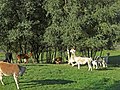 Alpacas grazing - geograph.org.uk - 985238.jpg 640 × 480; 176 KB
-
 Alpacas in a field - geograph.org.uk - 379131.jpg 640 × 480; 164 KB
-
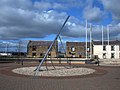 High Noon, Amble - geograph.org.uk - 358832.jpg 640 × 480; 114 KB
-
 An ex level crossing on Beal Lane. - geograph.org.uk - 1544845.jpg 640 × 480; 113 KB
-
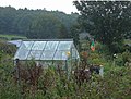
 An old fashioned Garden Centre - geograph.org.uk - 197445.jpg 640 × 468; 179 KB
-
 An old petrol pump - geograph.org.uk - 1499717.jpg 480 × 640; 118 KB
-
 An old shed - geograph.org.uk - 848339.jpg 640 × 468; 159 KB
-
 An old tree - geograph.org.uk - 619331.jpg 474 × 640; 195 KB
-

-
 Anglezarke Reservoir - geograph.org.uk - 1073025.jpg 640 × 424; 47 KB
-
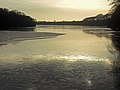 Anglezarke Reservoir - geograph.org.uk - 1077100.jpg 640 × 480; 77 KB
-
 Anstruther's seafront - geograph.org.uk - 1249513.jpg 640 × 460; 112 KB
-
 Antioch, Rakewood Road, Littleborough - geograph.org.uk - 665516.jpg 640 × 473; 160 KB
-
 Antrobus - Frandley Signpost.jpg 640 × 482; 132 KB
-
 Any old iron^ - geograph.org.uk - 174430.jpg 640 × 480; 121 KB
-
 Apperley Road - geograph.org.uk - 794461.jpg 640 × 473; 146 KB
-

-
 Approaching Broadrake Farm - geograph.org.uk - 1552136.jpg 640 × 480; 91 KB
-
 Approaching Dean Farm - geograph.org.uk - 1140917.jpg 640 × 466; 141 KB
-
 Approaching Gordale Scar - geograph.org.uk - 1260675.jpg 640 × 438; 134 KB
-
 Approaching Newhey - geograph.org.uk - 748445.jpg 640 × 457; 101 KB
-
 Approaching Pots 'n' Pans - geograph.org.uk - 950430.jpg 640 × 480; 75 KB
-
 Approaching Rake Head - geograph.org.uk - 974587.jpg 640 × 480; 121 KB
-
 Approaching the end of Redford Road - geograph.org.uk - 1011280.jpg 452 × 640; 124 KB
-
 Approaching the Sportsmans Arms - geograph.org.uk - 724943.jpg 640 × 476; 88 KB
-

-
 Aqueduct over the River Hodder - geograph.org.uk - 892330.jpg 640 × 480; 98 KB
-
 Aqueduct over the River Wharfe - geograph.org.uk - 1050435.jpg 640 × 461; 102 KB
-
 Arden Quarry, Birch Vale - geograph.org.uk - 1066848.jpg 640 × 440; 54 KB
-
 Arley Brook - geograph.org.uk - 147689.jpg 640 × 480; 189 KB
-

-
 Arnfield Lane, Tintwistle - geograph.org.uk - 1066941.jpg 640 × 457; 114 KB
-
 Artengill Viaduct - geograph.org.uk - 1582693.jpg 640 × 419; 97 KB
-
 ASDA comes to Shaw - geograph.org.uk - 521440.jpg 640 × 500; 122 KB
-
 Asda, Rooley Lane, Bowling, Bradford - geograph.org.uk - 886940.jpg 640 × 412; 78 KB
-
 Ashton Market - geograph.org.uk - 798767.jpg 640 × 480; 106 KB
-
 Ashton's indoor market - geograph.org.uk - 1121809.jpg 640 × 480; 125 KB
-
 Ashton's Indoor Market Hall - geograph.org.uk - 798792.jpg 640 × 453; 114 KB
-
 Ashworth Fold - geograph.org.uk - 1080860.jpg 640 × 480; 113 KB
-
 Ashworth Fold - geograph.org.uk - 1080863.jpg 640 × 480; 108 KB
-
 Aston Arms, Mill Lane, Frodsham - geograph.org.uk - 1544615.jpg 640 × 480; 100 KB
-
 Autumn Moss - geograph.org.uk - 588824.jpg 640 × 480; 276 KB
-
 B4479 north of Paxford - geograph.org.uk - 233858.jpg 640 × 480; 143 KB
-
 B5289, Gatesgarth - geograph.org.uk - 1274666.jpg 475 × 640; 152 KB
-
 B5289, Honister Pass - geograph.org.uk - 892347.jpg 640 × 480; 111 KB
-
 B5289, Rosthwaite - geograph.org.uk - 892338.jpg 640 × 474; 144 KB
-
 B5391, Higher Wincham, Cheshire - geograph.org.uk - 147676.jpg 640 × 480; 149 KB
-
 B6478 Newton Bridge - geograph.org.uk - 892296.jpg 640 × 480; 97 KB
-
 Back alley, Colne - geograph.org.uk - 1168220.jpg 480 × 640; 125 KB
-
 Back of The Rock, Bury - geograph.org.uk - 750630.jpg 640 × 476; 127 KB
-
 Back yard, Holmfirth - geograph.org.uk - 970549.jpg 480 × 640; 128 KB
-
 Bacup Post Office - geograph.org.uk - 110733.jpg 640 × 491; 114 KB
-
 Bacup Road, Rawtenstall - geograph.org.uk - 1199668.jpg 640 × 434; 87 KB
-
 Badbury Rings Trig Pillar - geograph.org.uk - 258947.jpg 640 × 473; 90 KB
-
 Badger Edge Lane - geograph.org.uk - 602687.jpg 640 × 451; 119 KB
-
 Badger Edge Lane - geograph.org.uk - 602698.jpg 640 × 480; 96 KB
-
 BAE Systems, Chadderton - geograph.org.uk - 877232.jpg 640 × 444; 88 KB
-
 Bag Brook, Monks Heath - geograph.org.uk - 151135.jpg 640 × 480; 155 KB
-
 Baggage, bees and bicycles - geograph.org.uk - 1253707.jpg 640 × 479; 136 KB
-
 Bakewell - geograph.org.uk - 713994.jpg 640 × 466; 151 KB
-
 Bakewell Puddings R Us - geograph.org.uk - 713951.jpg 640 × 458; 145 KB
-
 Bamford Road - geograph.org.uk - 900438.jpg 640 × 398; 74 KB
-
 Bandstand, Elland - geograph.org.uk - 897954.jpg 467 × 640; 101 KB
-
 Bandstand, Saltwell Park - geograph.org.uk - 1045689.jpg 640 × 481; 134 KB
-
 Bank Newton - geograph.org.uk - 1046116.jpg 640 × 480; 155 KB
-
 Bank Terrace, Mytholm - geograph.org.uk - 1045226.jpg 640 × 463; 106 KB
-
 Bank View Cafe, Langsett (2) - geograph.org.uk - 1023943.jpg 502 × 640; 97 KB
-
 Bar Lane, Boston Spa - geograph.org.uk - 295507.jpg 640 × 458; 68 KB
-
 Barden Bridge - geograph.org.uk - 1050447.jpg 640 × 480; 113 KB
-
 Barley Village Hall - geograph.org.uk - 172082.jpg 482 × 640; 112 KB
-
 Barn above the Ogden Valley - geograph.org.uk - 1732295.jpg 640 × 414; 93 KB
-

-
 Bavelaw, Pentlands, south of Edinburgh - geograph.org.uk - 95989.jpg 640 × 480; 215 KB
-
 Be afraid - geograph.org.uk - 1077910.jpg 640 × 480; 108 KB
-
 Beach Cafe, Charmouth - geograph.org.uk - 1273439.jpg 640 × 411; 75 KB
-
 Beachcombing for fossils - geograph.org.uk - 1273424.jpg 640 × 480; 90 KB
-
 Beacom Houses - geograph.org.uk - 1102692.jpg 640 × 480; 144 KB
-
 Beacon Hill trig Pillar, Halifax - geograph.org.uk - 842001.jpg 640 × 475; 157 KB
-
 Beastfair Vaults - geograph.org.uk - 1734543.jpg 640 × 480; 94 KB
-
 Beatrix Farm - geograph.org.uk - 892279.jpg 640 × 480; 95 KB
-
 The Church of St Gregory, Bedale - geograph.org.uk - 358881.jpg 461 × 640; 125 KB
-
 Bedale Signal Box - geograph.org.uk - 358887.jpg 640 × 465; 115 KB
-
 Beetham Tower, Deansgate, Manchester.jpg 429 × 640; 83 KB
-
 Behind the shops - geograph.org.uk - 1183343.jpg 469 × 640; 115 KB
-
 Belmont House, Great Budworth - geograph.org.uk - 147736.jpg 640 × 362; 122 KB
-
 Belmont Reservoir - geograph.org.uk - 217530.jpg 640 × 464; 92 KB
-
 Belmont Reservoir - geograph.org.uk - 217564.jpg 640 × 480; 115 KB
-
 Belmont Road, Rivington - geograph.org.uk - 593194.jpg 640 × 461; 105 KB
-
 Ben Healey Bridge, Littleborough - geograph.org.uk - 561899.jpg 640 × 471; 98 KB
-
 Bench mark on Bradbury's Lane - geograph.org.uk - 1096051.jpg 640 × 480; 156 KB
-
 Benchmark and Flood Mark, Delph - geograph.org.uk - 337323.jpg 640 × 478; 139 KB
-
 Benchmark on a milestone - geograph.org.uk - 785611.jpg 487 × 640; 126 KB
-
 St Andrews Wallace Green - geograph.org.uk - 1120391.jpg 480 × 640; 74 KB
-
 Besom Hill - geograph.org.uk - 736780.jpg 640 × 461; 80 KB
-
 Besom Hill Farm above Shaw - geograph.org.uk - 1721285.jpg 640 × 464; 102 KB
-
 Besom Hill Reservoir - geograph.org.uk - 225681.jpg 640 × 480; 117 KB
-

-
 Beware of the poseur - geograph.org.uk - 1183105.jpg 640 × 468; 132 KB
-
 Bicycles in York - geograph.org.uk - 3187288.jpg 2,000 × 1,333; 2.32 MB
-
 Big descent, big views - geograph.org.uk - 1194132.jpg 640 × 480; 112 KB
-
 Bike in Birchen Clough - geograph.org.uk - 1538189.jpg 640 × 480; 171 KB
-
 Bike on a narrowboat - geograph.org.uk - 881679.jpg 640 × 429; 94 KB
-
 Bilberry on a post - geograph.org.uk - 980690.jpg 477 × 640; 98 KB
-
 Birch on Crompton Moor - geograph.org.uk - 1743349.jpg 444 × 640; 152 KB
-
 Birchenlea Street, Oldham - geograph.org.uk - 877186.jpg 640 × 460; 146 KB
-
 Birchinley Hall, near Milnrow - geograph.org.uk - 83822.jpg 640 × 455; 113 KB
-
 Bird i' th' Hand, Heywood - geograph.org.uk - 954501.jpg 640 × 480; 85 KB
-
 Bird i'th Hand, Warland - geograph.org.uk - 280145.jpg 640 × 453; 115 KB
-
 Birds please note - geograph.org.uk - 1096159.jpg 640 × 480; 104 KB
-
 Bishop Park Monument - geograph.org.uk - 225677.jpg 483 × 640; 111 KB
-
 Bishop Wood - geograph.org.uk - 197441.jpg 640 × 480; 161 KB
-
 Black Bull Hotel, Haslingden - geograph.org.uk - 1138218.jpg 640 × 457; 97 KB
-
 Black Horse Inn, Clifton - geograph.org.uk - 598810.jpg 640 × 451; 79 KB
-
 Black Horse Inn, Clifton - geograph.org.uk - 598834.jpg 640 × 483; 65 KB
-
 Black is the new Red - geograph.org.uk - 155408.jpg 466 × 640; 115 KB
-
 Black K6 telephone boxes - geograph.org.uk - 1290766.jpg 480 × 640; 95 KB
-
 Blackbeck Tarn - geograph.org.uk - 1281627.jpg 640 × 480; 71 KB
-
 Blackford Hill summit - geograph.org.uk - 928601.jpg 640 × 475; 106 KB
-
 Blackfriars Street - geograph.org.uk - 928737.jpg 461 × 640; 92 KB
-
 Blackstone Edge Trig Pillar - geograph.org.uk - 463993.jpg 640 × 479; 75 KB
-
 Blea Moor signal box - geograph.org.uk - 1552094.jpg 480 × 640; 79 KB
-
 Bleakedgate Moor - geograph.org.uk - 575528.jpg 640 × 480; 112 KB
-
 Blinkbonny Public Park - geograph.org.uk - 1093587.jpg 640 × 480; 165 KB
-
 Blue Willow Tea Room - geograph.org.uk - 912768.jpg 640 × 480; 126 KB
-
 Bluebells at Old House Ground - geograph.org.uk - 427824.jpg 640 × 480; 187 KB
-
 BMX Pump Track, Whitley Bay, UK.jpg 640 × 477; 91 KB
-
 Boarded-up shop on Eldon Street - geograph.org.uk - 807820.jpg 640 × 406; 90 KB
-
 Boardwalk on a bridleway - geograph.org.uk - 797971.jpg 640 × 480; 153 KB
-
 Boars Head Pudsey - geograph.org.uk - 1724824.jpg 458 × 640; 100 KB
-
 Boarshaw Bridge, Rochdale Canal - geograph.org.uk - 385280.jpg 640 × 480; 103 KB
-
 Boat hire kiosk - geograph.org.uk - 865266.jpg 640 × 461; 76 KB
-
 Boatyard, Hollingworth Lake - geograph.org.uk - 561902.jpg 640 × 478; 114 KB
-
 Boggart Lane, Sowerby Bridge - geograph.org.uk - 985130.jpg 640 × 467; 108 KB
-
 Boggy Bridleway - geograph.org.uk - 575539.jpg 640 × 480; 97 KB


_-_geograph.org.uk_-_1499948.jpg)


_Stake_Hill_-_geograph.org.uk_-_719927.jpg)
,_Thornham_-_geograph.org.uk_-_330739.jpg)


_-_geograph.org.uk_-_1023943.jpg)


