Category:Images by Paul Buckingham

Media in category "Images by Paul Buckingham"
The following 200 files are in this category, out of 413 total.
(previous page) (next page)-

-

-
 Al Saints Church, Shillington - geograph.org.uk - 1529862.jpg 640 × 427; 56 KB
-
 All Saints Church - geograph.org.uk - 1557274.jpg 640 × 425; 108 KB
-
 All Saints Church - geograph.org.uk - 1557291.jpg 640 × 425; 100 KB
-
 Alton Castle - geograph.org.uk - 1711966.jpg 853 × 1,280; 362 KB
-
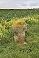
 Ancient Milestone, B6277 - geograph.org.uk - 1568368.jpg 640 × 427; 163 KB
-
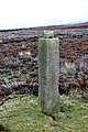 Ancient Way Marker, Ingleby Moor - geograph.org.uk - 1577660.jpg 425 × 640; 89 KB
-
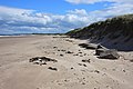 Anti Tank cubes, Druridge Bay - geograph.org.uk - 1965861.jpg 1,280 × 853; 278 KB
-
 Arch, Craster Harbour - geograph.org.uk - 1594195.jpg 640 × 427; 67 KB
-
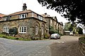
 Arden Hall Cottages - geograph.org.uk - 1546447.jpg 640 × 427; 87 KB
-

-
 Arguments Yard, Whitby - geograph.org.uk - 1535673.jpg 480 × 640; 49 KB
-
 Arncliffe Hall - geograph.org.uk - 1557281.jpg 640 × 419; 115 KB
-
 Attingham Hall, Shropshire - geograph.org.uk - 1535676.jpg 640 × 480; 60 KB
-
 Autumn Colours, Gormire Lake - geograph.org.uk - 1540612.jpg 640 × 419; 81 KB
-
 Aysgarth Lower Falls - geograph.org.uk - 1538810.jpg 640 × 430; 98 KB
-
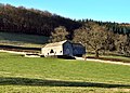
 Bainley Bank Farm, Great Fryup Dale - geograph.org.uk - 1546533.jpg 640 × 427; 71 KB
-
 Bank Foot Cottage - geograph.org.uk - 1537447.jpg 640 × 427; 57 KB
-
 Bank Foot Farm, Ingleby Greenhow - geograph.org.uk - 1636541.jpg 640 × 425; 66 KB
-
 Bank Foot Lane - geograph.org.uk - 1537400.jpg 640 × 427; 79 KB
-
 Bank Foot Lane in the snow - geograph.org.uk - 1636524.jpg 640 × 427; 62 KB
-
 Bankside Farm - geograph.org.uk - 1603121.jpg 640 × 427; 74 KB
-
 Barbury Castle, Wiltshire - geograph.org.uk - 1530103.jpg 457 × 640; 78 KB
-

-
 Barkers Crags, Scugdale - geograph.org.uk - 1529414.jpg 640 × 427; 70 KB
-
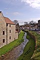
 Barn by the Borough Beck, Helmsley - geograph.org.uk - 1767191.jpg 1,280 × 844; 475 KB
-
 Barn near Marske Hall - geograph.org.uk - 1712006.jpg 1,280 × 914; 496 KB
-

-
 Battlesden Lake - geograph.org.uk - 1650853.jpg 640 × 427; 70 KB
-
 Baulk Bridge Farm, Nr East Harlsey - geograph.org.uk - 1708730.jpg 1,280 × 989; 369 KB
-
 Beacon Tower, Crich Stand - geograph.org.uk - 1731431.jpg 853 × 1,280; 287 KB
-
 Bell House, Coxwold - geograph.org.uk - 1569150.jpg 640 × 425; 47 KB
-
 Birchington House, nr. Netherseal - geograph.org.uk - 1581756.jpg 640 × 427; 72 KB
-
 Blagraves House Restaurant, Barnard Castle - geograph.org.uk - 1716361.jpg 1,280 × 853; 326 KB
-
 Blind Beck, nr. Ribblehead - geograph.org.uk - 1530083.jpg 425 × 640; 58 KB
-

-
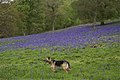 Bluebells, Riccall Dale - geograph.org.uk - 1467699.jpg 640 × 425; 92 KB
-
 Boats, Mullion Cove - geograph.org.uk - 1542309.jpg 640 × 414; 65 KB
-
 Borough Beck, Helmsley - geograph.org.uk - 1764646.jpg 852 × 1,280; 359 KB
-
 Bothenhampton, Nr Bridport - geograph.org.uk - 1680173.jpg 1,280 × 960; 649 KB
-
 Bowes-Lyon Bridge, Crich Tramway museum - geograph.org.uk - 1731446.jpg 1,280 × 840; 531 KB
-
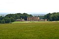
 Bowood House - geograph.org.uk - 1467658.jpg 640 × 427; 68 KB
-
 Brecken Hill - geograph.org.uk - 1691366.jpg 1,280 × 914; 363 KB
-
 Bremhill church, Wiltshire - geograph.org.uk - 1529429.jpg 640 × 425; 57 KB
-
 Brimham Rocks - geograph.org.uk - 1650824.jpg 640 × 426; 55 KB
-

-
 Brompton Beck - geograph.org.uk - 1711854.jpg 853 × 1,280; 563 KB
-
 Caerlaverock Castle - geograph.org.uk - 1538522.jpg 640 × 427; 74 KB
-
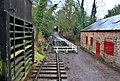
 Caldon Canal, Froghall - geograph.org.uk - 1537238.jpg 640 × 427; 82 KB
-
 Caldon Canal, Froghall - geograph.org.uk - 1537241.jpg 427 × 640; 55 KB
-
 Canons Ashby House - geograph.org.uk - 1755217.jpg 1,280 × 960; 408 KB
-
 Captain Cooks Monument - geograph.org.uk - 1567146.jpg 640 × 480; 85 KB
-
 Carlisle Castle - geograph.org.uk - 1540635.jpg 640 × 425; 43 KB
-
 Carlisle Cathedral - geograph.org.uk - 1540633.jpg 640 × 446; 73 KB
-

-
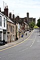 Castle Street, Warkworth - geograph.org.uk - 1680198.jpg 853 × 1,280; 405 KB
-
 Cat and Bagpipes Rear View - geograph.org.uk - 1626888.jpg 640 × 444; 53 KB
-
 Channel Island Ferry, Weymouth - geograph.org.uk - 1595354.jpg 640 × 480; 72 KB
-
 Church of the Holy Cross, Ilam - geograph.org.uk - 1716367.jpg 1,280 × 853; 445 KB
-
 Church Street, Netherseal - geograph.org.uk - 1576808.jpg 640 × 426; 65 KB
-
 Churchyard trees, Whorlton Church - geograph.org.uk - 1718670.jpg 853 × 1,280; 500 KB
-
 Churchyard, East Harlsey - geograph.org.uk - 1535502.jpg 427 × 640; 102 KB
-
 Cleveland Way Finger Post, Kettleness - geograph.org.uk - 1736541.jpg 849 × 1,280; 419 KB
-
 Cley Windmill, Cley Next The Sea - geograph.org.uk - 1595388.jpg 480 × 640; 85 KB
-
 Clove Carr - geograph.org.uk - 1540607.jpg 640 × 427; 46 KB
-
 Clovelly Harbour from the Harbour Wall - geograph.org.uk - 1603129.jpg 640 × 427; 111 KB
-

-

-

-
 Confluence of the River Ouse and River Foss, York - geograph.org.uk - 3647865.jpg 1,952 × 2,928; 2.25 MB
-
 Converted Mill Tower, Melbourne - geograph.org.uk - 1537405.jpg 427 × 640; 65 KB
-
-
 Converted Windmill, Brompton - geograph.org.uk - 1711844.jpg 853 × 1,280; 466 KB
-
 Corfe Castle - geograph.org.uk - 1637661.jpg 480 × 640; 75 KB
-
 Cottage, Gammersgill - geograph.org.uk - 1538472.jpg 640 × 457; 128 KB
-
 Cottage, Runswick Bay - geograph.org.uk - 1536701.jpg 640 × 480; 110 KB
-
 Cottages, Runswick Bay - geograph.org.uk - 1536704.jpg 480 × 640; 106 KB
-
 Coxwold Church - geograph.org.uk - 1569140.jpg 640 × 415; 73 KB
-
 Craster Harbour Panorama - geograph.org.uk - 1540589.jpg 640 × 390; 52 KB
-
 Crayke Castle, Hambledon, North Yorkshire.jpg 1,280 × 960; 819 KB
-
-
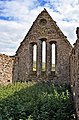
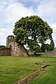 Croxden Abbey - geograph.org.uk - 1537248.jpg 427 × 640; 76 KB
-
 Croxden Abbey - geograph.org.uk - 1537250.jpg 427 × 640; 67 KB
-
 Cudden Point - geograph.org.uk - 1540636.jpg 640 × 427; 56 KB
-
 Dead End, Lockton - geograph.org.uk - 1535468.jpg 457 × 640; 79 KB
-

-
 Deepdale Farm, Near East Harlsey - geograph.org.uk - 1568506.jpg 640 × 410; 82 KB
-
 Derelict Barn, East Harlsey - geograph.org.uk - 1691327.jpg 1,280 × 850; 486 KB
-
 Derelict Barn, Foxton - geograph.org.uk - 1711614.jpg 1,280 × 853; 509 KB
-
 Derwent Dam - geograph.org.uk - 1755224.jpg 960 × 1,280; 366 KB
-
 Dredger "Rebecca M" at Whitby - geograph.org.uk - 1544335.jpg 640 × 422; 53 KB
-
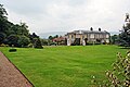
 Duncombe House - geograph.org.uk - 1594171.jpg 640 × 427; 52 KB
-
 Durdle Door - geograph.org.uk - 1637651.jpg 640 × 480; 95 KB
-
-
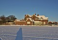
 East Harlsey in the Snow - geograph.org.uk - 1626866.jpg 640 × 425; 103 KB
-
 East Harlsey Village Hall - geograph.org.uk - 1626878.jpg 640 × 425; 115 KB
-
 East Tytherton, Wiltshire - geograph.org.uk - 1530097.jpg 640 × 457; 77 KB
-
 Elmgill Farm, below Mallerstang Edge - geograph.org.uk - 1702176.jpg 1,280 × 812; 414 KB
-
-

-
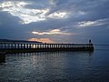
 Evening at Welcombe Mouth - geograph.org.uk - 1537440.jpg 640 × 427; 78 KB
-
 Faceby Village Hall - geograph.org.uk - 1718712.jpg 1,280 × 853; 329 KB
-
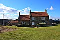
 Farm at Harlsey Castle - geograph.org.uk - 1127784.jpg 640 × 427; 70 KB
-
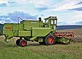
 Farm Equipment, Morton Grange Farm - geograph.org.uk - 1544664.jpg 640 × 426; 78 KB
-
 Farm House at Bushy Park, Marske - geograph.org.uk - 1711994.jpg 1,600 × 1,067; 429 KB
-
 Farm Outbuilding, Bank Foot Farm - geograph.org.uk - 1592735.jpg 640 × 426; 74 KB
-
 Farm Track between Faceby and Whorlton - geograph.org.uk - 1718656.jpg 1,280 × 853; 384 KB
-
 Farm Track, Bank Foot farm - geograph.org.uk - 1537449.jpg 427 × 640; 89 KB
-
 Feeding Time, Bank Foot farm - geograph.org.uk - 1540618.jpg 427 × 640; 100 KB
-
 Field Barn, near Keisley - geograph.org.uk - 1528318.jpg 640 × 427; 53 KB
-
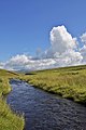
 Field by Settle to Carlisle Railway - geograph.org.uk - 1701242.jpg 1,280 × 850; 221 KB
-
-
 Field in Snow, East Harlsey - geograph.org.uk - 1654796.jpg 640 × 427; 79 KB
-
 Field, Bank Foot, Ingleby Greenhow - geograph.org.uk - 1636520.jpg 640 × 425; 49 KB
-
-
 Fishermans Cottage, Penberth - geograph.org.uk - 1541624.jpg 640 × 423; 70 KB
-
 Fishermen, Whitby Pier - geograph.org.uk - 1535672.jpg 640 × 480; 60 KB
-
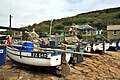 Fishing Boats, Penberth Cove - geograph.org.uk - 1564947.jpg 640 × 425; 86 KB
-
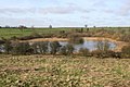
 Fishing ponds near Bank Lane - geograph.org.uk - 1718702.jpg 1,280 × 853; 449 KB
-
 Flatford Mill - geograph.org.uk - 1615895.jpg 640 × 480; 74 KB
-
 Flue at Grinton Smelt Mil - geograph.org.uk - 1538782.jpg 640 × 426; 72 KB
-

-
 Footbridge over Harwood Beck - geograph.org.uk - 1535443.jpg 640 × 427; 74 KB
-
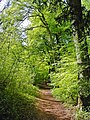 Footpath along Selborne Hanger - geograph.org.uk - 1536818.jpg 480 × 640; 168 KB
-
 Forestry Road, Bank Foot - geograph.org.uk - 1636534.jpg 640 × 425; 79 KB
-
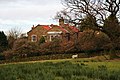
 Frog Hall - geograph.org.uk - 1535459.jpg 640 × 427; 52 KB
-

-
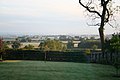
 Gardens, Bowood House - geograph.org.uk - 1572433.jpg 640 × 457; 88 KB
-

-
 Gate of Forestry Road, Bank Foot - geograph.org.uk - 1636530.jpg 640 × 427; 102 KB
-
 Gayle Beck, Gayle - geograph.org.uk - 1547099.jpg 640 × 427; 99 KB
-
 Gayle Mill - geograph.org.uk - 1711981.jpg 1,280 × 853; 437 KB
-
 Glaisdale Mill - geograph.org.uk - 1714497.jpg 1,280 × 824; 561 KB
-
 Glasgow Tram, Crich Tramway Museum - geograph.org.uk - 1731461.jpg 853 × 1,280; 333 KB
-
 Godrevy Island - geograph.org.uk - 1540638.jpg 640 × 418; 58 KB
-
 Goosecroft Lane, East Harlsey - geograph.org.uk - 1626895.jpg 640 × 425; 75 KB
-

-
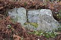
 Gravestone in Duncombe Park - geograph.org.uk - 1529571.jpg 427 × 640; 86 KB
-
 Graveyard,Whorlton Church - geograph.org.uk - 1718681.jpg 1,280 × 853; 650 KB
-
 Grays Court, York - geograph.org.uk - 1555973.jpg 640 × 421; 89 KB
-
 Grinton Lodge Youth Hostel - geograph.org.uk - 2108175.jpg 1,280 × 851; 298 KB
-
 Guest House, Mount Grace Priory - geograph.org.uk - 1544876.jpg 640 × 427; 78 KB
-
 Guise Cliff, nr. Pateley Bridge - geograph.org.uk - 1529507.jpg 426 × 640; 105 KB
-
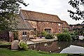 Gurney Manor Mill - geograph.org.uk - 1515122.jpg 640 × 425; 97 KB
-
 Hanbury Hall and Parterre Garden - geograph.org.uk - 1548449.jpg 640 × 480; 94 KB
-
 Hangar, Yorkshire Gliding Club - geograph.org.uk - 1544281.jpg 640 × 425; 65 KB
-
 Harbour Entrance, Whitby - geograph.org.uk - 1736537.jpg 1,280 × 884; 393 KB
-
 Harbour Mouth, Hartlepool - geograph.org.uk - 1476787.jpg 640 × 427; 78 KB
-
 Harbour Mouth, St Michaels Mount - geograph.org.uk - 1540637.jpg 640 × 423; 57 KB
-
 Harbourside cottages, Staithes - geograph.org.uk - 1536732.jpg 640 × 480; 75 KB
-
 Hardraw Force - geograph.org.uk - 1429787.jpg 426 × 640; 52 KB
-
 Harlsey Beck - geograph.org.uk - 1691320.jpg 640 × 425; 132 KB
-
 Harlsey Hall - geograph.org.uk - 1535491.jpg 640 × 427; 70 KB
-
 Hartlepool Marina - geograph.org.uk - 1544892.jpg 640 × 425; 45 KB
-
 Harvest Time, Bank Foot Farm - geograph.org.uk - 1595006.jpg 640 × 457; 72 KB
-
 Hawnby Panorama from above Peak Scar - geograph.org.uk - 1529565.jpg 640 × 259; 39 KB
-
 Heights of Abraham Cable Car, Bottom Station - geograph.org.uk - 1731177.jpg 1,280 × 792; 423 KB
-
 Heights of Abraham Cable Car, Top Station - geograph.org.uk - 1731186.jpg 1,280 × 853; 619 KB
-
 Helmsley Castle - geograph.org.uk - 1764644.jpg 1,280 × 848; 255 KB
-
 Herdship Farm - geograph.org.uk - 1535452.jpg 640 × 427; 65 KB
-

-
 High Cup Gill - geograph.org.uk - 1540621.jpg 640 × 421; 74 KB
-
 High Cup Nick - geograph.org.uk - 1623863.jpg 640 × 427; 81 KB
-
 High Farm, Faceby - geograph.org.uk - 1718706.jpg 1,280 × 853; 339 KB
-
 High Farm, Ingleby Greenhow - geograph.org.uk - 1529842.jpg 640 × 427; 88 KB
-
 High Peak Trail, Friden - geograph.org.uk - 1731101.jpg 853 × 1,280; 471 KB
-
 High Peak Trail, High Peak Junction - geograph.org.uk - 1731149.jpg 1,280 × 864; 497 KB
-
 High Street, Chipping Campden - geograph.org.uk - 1650495.jpg 640 × 425; 69 KB
-
 High Tide, Bosham - geograph.org.uk - 1581757.jpg 640 × 480; 58 KB
-
 Horse riding at Saltburn Pier - geograph.org.uk - 1527910.jpg 640 × 430; 72 KB
-
 Houghton House, Nr. Ampthill - geograph.org.uk - 1650806.jpg 640 × 427; 66 KB
-
 House and Cottage, Water End, Brompton - geograph.org.uk - 1711876.jpg 1,280 × 853; 511 KB
-
 House and Garden, Hints - geograph.org.uk - 1537443.jpg 640 × 427; 90 KB
-
 Houses in West Burton - geograph.org.uk - 1149716.jpg 640 × 427; 120 KB
-
 I Wonder What's for Dinner - geograph.org.uk - 1700915.jpg 850 × 1,280; 461 KB
-
 Incline Road, Ingleby Greenhow - geograph.org.uk - 1636431.jpg 640 × 425; 83 KB
-
 Incoming Tide, South Gare breakwater - geograph.org.uk - 1718857.jpg 1,280 × 853; 375 KB
-
 Ingleby Beck - geograph.org.uk - 1540584.jpg 427 × 640; 125 KB
-
 Ingleby Manor, Rear View - geograph.org.uk - 1567118.jpg 640 × 480; 85 KB
-
 Inner Farne - geograph.org.uk - 1594143.jpg 640 × 427; 48 KB
-
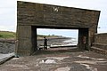
 Inside Heugh Battery Geograph 1997113 e0d8d665.jpg 1,280 × 853; 342 KB
-

-

-
-
 Iron Sculpture, Cleveland Way - geograph.org.uk - 2026648.jpg 1,280 × 960; 443 KB
-
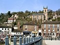 Ironbridge Town - geograph.org.uk - 1637666.jpg 640 × 480; 101 KB
-
 Ironwork detail, Ironbridge - geograph.org.uk - 1535678.jpg 457 × 640; 104 KB
-
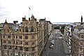 Jenners Department Store, Edinburgh - geograph.org.uk - 1594967.jpg 640 × 427; 68 KB
-
 Jim Bells Stile, Robin Hoods Bay - geograph.org.uk - 1530119.jpg 425 × 640; 82 KB
-
 Kenneggy Sands at Low Tide - geograph.org.uk - 1535117.jpg 640 × 416; 60 KB
-
 Kersey Watersplash - geograph.org.uk - 1536721.jpg 640 × 443; 101 KB
-
 Kettleness Farm, Kettleness - geograph.org.uk - 1736542.jpg 1,280 × 853; 388 KB
-
 Kettleness from the Cleveland Way - geograph.org.uk - 1736540.jpg 1,280 × 853; 390 KB
-
 Kildale Station, North Yorkshire.jpg 1,280 × 960; 669 KB
-
-
 Lake at Newburgh Priory - geograph.org.uk - 1569137.jpg 640 × 421; 35 KB
-
 Lake, Harlsey Hall gardens - geograph.org.uk - 1535497.jpg 640 × 415; 83 KB
-
 Lake, Trewithen Gardens - geograph.org.uk - 1542285.jpg 640 × 425; 101 KB
-
 Lakeside Folly, Bowood House Gardens - geograph.org.uk - 1572438.jpg 640 × 427; 84 KB


