Category:Images by Richard Hoare

Media in category "Images by Richard Hoare"
The following 200 files are in this category, out of 714 total.
(previous page) (next page)-

-
 ''Rusting'' barge at Porth Penrhyn - geograph.org.uk - 1446916.jpg 640 × 480; 96 KB
-

-
 'Cool running' at Glan Conwy - geograph.org.uk - 1434748.jpg 640 × 480; 87 KB
-
 124 Douglas Road Castletown George V postbox - geograph.org.uk - 1708054.jpg 3,296 × 2,472; 1.95 MB
-
 126 Bowling Green Road - postbox - geograph.org.uk - 1711136.jpg 2,472 × 3,296; 1.85 MB
-
 17th Green Sandilands Golf Course - geograph.org.uk - 1501491.jpg 640 × 480; 56 KB
-
-
 A Flybe Bombardier Dash 8 at Ronaldsway Airport - geograph.org.uk - 1702114.jpg 3,296 × 2,472; 1.9 MB
-

-

-
 A Green Goddess - geograph.org.uk - 1801787.jpg 3,296 × 2,472; 1.94 MB
-

-
 A sad building in Conwy - geograph.org.uk - 1472971.jpg 640 × 480; 58 KB
-
 A sidings issue at Dinas Station - geograph.org.uk - 1456935.jpg 640 × 480; 112 KB
-
 A time machine - geograph.org.uk - 1415797.jpg 640 × 480; 59 KB
-
-
-
 Above the A55 at Llandudno Junction - geograph.org.uk - 1463132.jpg 640 × 480; 54 KB
-
 Aircraft recovery trolleys Manx Aviation Museum Ronaldsway - geograph.org.uk - 1707411.jpg 3,296 × 2,472; 1.99 MB
-
 Aircraft recovery trolleys Manx Aviation Museum Ronaldsway - geograph.org.uk - 1707420.jpg 3,296 × 2,472; 2.02 MB
-
 Alford - geograph-3697296-by-Richard-Hoare.jpg 640 × 480; 69 KB
-
 Alford - geograph-3700029-by-Richard-Hoare.jpg 640 × 480; 67 KB
-
 All Saints Church Theddlethorpe All Saints - geograph.org.uk - 1804118.jpg 3,296 × 2,472; 2.11 MB
-
 All Saints Church Theddlethorpe All Saints - geograph.org.uk - 1804120.jpg 2,472 × 3,296; 1.85 MB
-
 An Albatross in Castletown - geograph.org.uk - 1700351.jpg 3,296 × 2,472; 1.94 MB
-
 An Alvis Stalwart - above Glan Conwy - geograph.org.uk - 1449553.jpg 640 × 480; 79 KB
-
 An Atom in Port Erin - geograph.org.uk - 1709539.jpg 3,200 × 1,800; 1.41 MB
-
 Anchor at Castletown - geograph.org.uk - 1700634.jpg 2,472 × 3,296; 1.88 MB
-
 Anchor at Porth Penryhn - geograph.org.uk - 1443859.jpg 640 × 480; 92 KB
-
 Angry sea and sky at Sutton on Sea - geograph.org.uk - 1617391.jpg 640 × 480; 37 KB
-
 Antique bicycles - geograph.org.uk - 1425397.jpg 640 × 480; 88 KB
-
 Approaching bridge 80 at Audlem - geograph.org.uk - 1748947.jpg 3,296 × 2,472; 1.96 MB
-

-
 Arriva Bus Depot Llandudno Junction - geograph.org.uk - 1463144.jpg 640 × 480; 56 KB
-
 Arriving at Grosmont - geograph.org.uk - 1448671.jpg 640 × 480; 70 KB
-
 St James the Great Church at Audlem - geograph.org.uk - 1748297.jpg 3,296 × 2,472; 1.95 MB
-
 The Buttermarket at Audlem - geograph.org.uk - 1748280.jpg 3,296 × 2,472; 1.89 MB
-
 Audlem Community Fire Station - geograph.org.uk - 1748055.jpg 3,296 × 2,472; 1.94 MB
-
 Axholmes Fish and Chip bar Castletown - geograph.org.uk - 1729736.jpg 3,296 × 2,472; 1.93 MB
-
 Back Belbeck Street Elton Bury - geograph.org.uk - 1571369.jpg 640 × 480; 59 KB
-
 Bagnios House - Castletown - geograph.org.uk - 1425476.jpg 640 × 480; 76 KB
-
 Balcony House Castletown - geograph.org.uk - 1705243.jpg 3,296 × 2,472; 1.84 MB
-
 Barclays Bank Castletown - geograph.org.uk - 1416016.jpg 640 × 480; 59 KB
-
 Barn at Ty-du farm - geograph.org.uk - 1617210.jpg 640 × 480; 95 KB
-
-
 Beach clearance Sutton on Sea - geograph.org.uk - 1779222.jpg 3,296 × 2,472; 1.94 MB
-
 Beach hut on Sandilands foreshore - geograph.org.uk - 1401544.jpg 640 × 480; 65 KB
-
 Beach huts at Sutton on Sea - geograph.org.uk - 1804145.jpg 3,296 × 2,472; 1.87 MB
-
 Beach huts at Sutton on Sea - geograph.org.uk - 1804164.jpg 3,296 × 2,472; 1.85 MB
-
 Beached hay bale at Deganwy - geograph.org.uk - 1770140.jpg 2,472 × 3,296; 1.74 MB
-
 Belbeck Street off Bolton Road - geograph.org.uk - 1544483.jpg 640 × 480; 64 KB
-

-
-
 Boat repairs at Caernarfon - geograph.org.uk - 1456923.jpg 640 × 480; 72 KB
-
 Boats at Conwy - geograph.org.uk - 1502445.jpg 640 × 480; 72 KB
-
 Boats at rest Port Erin - geograph.org.uk - 1703201.jpg 3,296 × 2,472; 1.91 MB
-
 Bodnant Garden - The Pin Mill - geograph.org.uk - 1402232.jpg 640 × 480; 34 KB
-
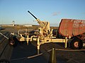 Bofors gun Ronaldsway - geograph.org.uk - 1703356.jpg 3,296 × 2,472; 1.9 MB
-
 Border plants at Lanhydrock - geograph.org.uk - 1426148.jpg 640 × 360; 109 KB
-

-
 Bowling Green Road Castletown - geograph.org.uk - 1711126.jpg 3,296 × 2,472; 1.91 MB
-
 Bradda Head from beach at Port Erin - geograph.org.uk - 1703292.jpg 3,296 × 2,472; 1.95 MB
-
 Breakwater and lighthouse at Castletown harbour - geograph.org.uk - 1700653.jpg 3,296 × 2,472; 1.98 MB
-
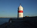 Breakwater Head lighthouse at Castletown harbour - geograph.org.uk - 1700675.jpg 3,296 × 2,472; 1.81 MB
-
 Bridge House and Bridge Cottage Castletown - geograph.org.uk - 1701566.jpg 3,296 × 2,472; 1.94 MB
-

-

-

-

-

-
 Bridgemere Garden World - geograph.org.uk - 1748136.jpg 2,472 × 3,296; 1.89 MB
-

-
 Bryn Ebenezer Chapel - Glan Conwy - geograph.org.uk - 1434717.jpg 640 × 480; 60 KB
-

-

-
 Bulgaria in Mablethorpe - geograph.org.uk - 1501745.jpg 640 × 480; 58 KB
-
 Bulgarian players at Mablethorpe - geograph.org.uk - 1506586.jpg 640 × 480; 42 KB
-
 Burroo Ned - geograph.org.uk - 1713758.jpg 3,296 × 2,472; 1.95 MB
-
 Bus Terminus at Port St Mary - geograph.org.uk - 1714461.jpg 3,296 × 2,472; 1.96 MB
-
 Caergwrle Station - geograph.org.uk - 1620066.jpg 640 × 480; 65 KB
-

-
 Caernarfon Castle - geograph.org.uk - 1394487.jpg 640 × 480; 78 KB
-
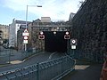 Caernarfons former railway tunnel - geograph.org.uk - 1466152.jpg 640 × 480; 67 KB
-
 Cafe with a difference - geograph.org.uk - 1432387.jpg 640 × 480; 92 KB
-
 Canal boat at Audlem - geograph.org.uk - 1766056.jpg 3,296 × 2,472; 2.01 MB
-
 Car Park Great Meadow Castletown - geograph.org.uk - 1475903.jpg 640 × 480; 62 KB
-
 Care sheep at two o'clock - geograph.org.uk - 1617231.jpg 640 × 480; 80 KB
-
 Carphone Warehouse Liverpool centre - geograph.org.uk - 1617425.jpg 640 × 480; 61 KB
-
 Castle Rushen - geograph.org.uk - 1401399.jpg 640 × 480; 66 KB
-
 Castle Rushen and outer harbour Castletown - geograph.org.uk - 1708075.jpg 3,296 × 2,472; 1.92 MB
-
 Castle Rushen in winter sunlight Castletown - geograph.org.uk - 1700365.jpg 3,296 × 2,472; 1.9 MB
-
 Castle Rushen stores - geograph.org.uk - 1416001.jpg 480 × 640; 88 KB
-

-
 Castletown foreshore - geograph.org.uk - 1704513.jpg 3,296 × 2,472; 1.92 MB
-
 Castletown Methodist Chapel - geograph.org.uk - 1425445.jpg 480 × 640; 73 KB
-
 Castletown square - geograph.org.uk - 1401267.jpg 640 × 480; 76 KB
-
 Castletown Square - geograph.org.uk - 1426135.jpg 640 × 480; 61 KB
-
 Cattle at Southern Show Castletown 2009 - geograph.org.uk - 1475912.jpg 640 × 480; 115 KB
-
 Ceint station platform and trackbed - geograph.org.uk - 1473160.jpg 480 × 640; 129 KB
-
 Chapel at Betws-y-coed - geograph.org.uk - 1432395.jpg 640 × 480; 82 KB
-

-
 Chester to Holyhead rail track at Llandudno Junction - geograph.org.uk - 1804537.jpg 3,296 × 2,472; 1.93 MB
-
 Childrens playground Llanrwst - geograph.org.uk - 1447972.jpg 640 × 480; 69 KB
-
 Childrens playground Sutton on Sea - geograph.org.uk - 1506558.jpg 640 × 480; 65 KB
-
-
-
 Clock adjacent to Castle Rushen - geograph.org.uk - 1467242.jpg 480 × 640; 82 KB
-

-
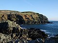
 Coastal footpath at The Sound - geograph.org.uk - 1713741.jpg 3,296 × 2,472; 2.05 MB
-
 Colby Glen pub - geograph.org.uk - 1719587.jpg 3,296 × 2,472; 1.91 MB
-

-
 Commemorative stone West Shore - geograph.org.uk - 1770168.jpg 3,296 × 2,472; 1.97 MB
-

-
 Control tower at Ronaldsway airport - geograph.org.uk - 1703441.jpg 3,296 × 2,472; 1.84 MB
-
 Control Tower at Strubby airfield - geograph.org.uk - 1603363.jpg 640 × 480; 41 KB
-
 Converted school at Port St Mary - geograph.org.uk - 1725159.jpg 3,296 × 2,472; 1.91 MB
-
 Conwy Castle - geograph.org.uk - 1463173.jpg 640 × 480; 43 KB
-
 Conwy Castle in silhouette - geograph.org.uk - 1653520.jpg 640 × 480; 25 KB
-
 Conwy Estuary - geograph.org.uk - 1401718.jpg 640 × 480; 48 KB
-
 Conwy Estuary Strategic Route at West Shore - geograph.org.uk - 1770180.jpg 3,296 × 2,472; 1.93 MB
-
 Coole Lane bridge - number 82 - near Audlem - geograph.org.uk - 1749166.jpg 3,296 × 2,472; 1.97 MB
-
 Cosmo at Romford - geograph.org.uk - 1778186.jpg 3,296 × 2,472; 1.91 MB
-
 Craft at rest Port St Mary - geograph.org.uk - 1725679.jpg 3,200 × 1,800; 1.4 MB
-
 Craft moored at Conwy Harbour - geograph.org.uk - 1653532.jpg 640 × 480; 57 KB
-
 Criccieth Castle at Tan-y-Bwlch - geograph.org.uk - 1478366.jpg 640 × 480; 81 KB
-
 Cross roads near Plas Isa - geograph.org.uk - 1448991.jpg 640 × 480; 75 KB
-

-
 Crossing lines at Minffordd - geograph.org.uk - 1478853.jpg 640 × 480; 75 KB
-

-
-

-

-
 Cut grass field near Cregneash - geograph.org.uk - 1475433.jpg 640 × 480; 60 KB
-
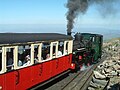 Departure from the summit of Snowdon - geograph.org.uk - 1486633.jpg 640 × 480; 79 KB
-
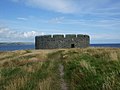 Derby Fort - nr Castletown - geograph.org.uk - 1425534.jpg 640 × 480; 65 KB
-
 Derby Fort and beyond - geograph.org.uk - 1444820.jpg 640 × 360; 62 KB
-
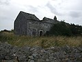
 Derelict building near Glasfryn - geograph.org.uk - 1492058.jpg 640 × 480; 96 KB
-
 Derelict building Penmachno - geograph.org.uk - 1509334.jpg 640 × 480; 82 KB
-
-
 Derelict House Sutton on Sea - geograph.org.uk - 1501860.jpg 640 × 480; 63 KB
-
 Derelict outbuildings Glan Conwy - geograph.org.uk - 1450404.jpg 640 × 480; 99 KB
-
 Deserted seafront at Sutton Sea - geograph.org.uk - 1603337.jpg 640 × 480; 36 KB
-

-
 Disused railway bed at Pentre Berw - geograph.org.uk - 1440048.jpg 480 × 640; 117 KB
-
 Disused railway bed at Pentre Berw - geograph.org.uk - 1440052.jpg 480 × 640; 130 KB
-
 Disused railway line at Gobowen - geograph.org.uk - 1620056.jpg 640 × 480; 86 KB
-
 Disused railway line at Gobowen - geograph.org.uk - 1620060.jpg 640 × 480; 80 KB
-

-
-
 Dockmasters Office at Porth Penrhyn - geograph.org.uk - 1446894.jpg 640 × 480; 53 KB
-
 Dockmasters Office Porth Penrhyn - geograph.org.uk - 1443865.jpg 640 × 480; 57 KB
-
 Dolgarrog Dam Disaster Boulders - geograph.org.uk - 1442049.jpg 640 × 480; 130 KB
-
 Double rainbow over River Conwy - geograph.org.uk - 1607529.jpg 640 × 480; 45 KB
-
 Douglas Harbour swing bridge - geograph.org.uk - 1712672.jpg 3,296 × 2,472; 1.92 MB
-
 Douglas Signal Box - geograph.org.uk - 1429670.jpg 640 × 480; 66 KB
-
 Dovecot at Pentre Berw - geograph.org.uk - 1444739.jpg 480 × 640; 97 KB
-
 Dovecote at Lost Gardens of Heligan - geograph.org.uk - 1423278.jpg 640 × 360; 72 KB
-
 Down the Zig Zag at Liverpool 1 - geograph.org.uk - 1463825.jpg 640 × 480; 66 KB
-
 Ducks being rescued on River Conwy - geograph.org.uk - 1471954.jpg 640 × 480; 127 KB
-

-
-
 Early morning winters sky Glan Conwy - geograph.org.uk - 1719539.jpg 3,296 × 2,472; 1.9 MB
-

-

-

-
 Edward VII postbox Douglas - geograph.org.uk - 1711153.jpg 2,472 × 3,296; 1.84 MB
-

-

-
 Elton Sailing Club (2) - geograph.org.uk - 1571379.jpg 640 × 480; 35 KB
-
-

-

-

-
 English Oak on Welsh Soil Llanrwst - geograph.org.uk - 1483364.jpg 640 × 480; 81 KB
-
 Ensis arcuatus - Sutton on Sea - geograph.org.uk - 1804156.jpg 3,296 × 2,472; 2.04 MB
-
-
 Entrance to Castletown Harbour - geograph.org.uk - 1700391.jpg 3,296 × 2,472; 1.91 MB
-
 Entrance to Douglas Harbour - geograph.org.uk - 1430387.jpg 640 × 480; 54 KB
-
 Entrance to new marina - Overwater - near Audlem - geograph.org.uk - 1749153.jpg 3,296 × 2,472; 1.84 MB
-

-

-
 Expired Spar in Conwy - geograph.org.uk - 1472607.jpg 640 × 480; 80 KB
-
 Fallen trees at Greenwood Centre - geograph.org.uk - 1446945.jpg 640 × 480; 144 KB
-
 Farm near head of Llyn Cwellyn - geograph.org.uk - 1457567.jpg 640 × 360; 83 KB
-
 Farm track Penmachno - geograph.org.uk - 1509371.jpg 640 × 480; 119 KB
-

-
 Field above Bryn - y - Maen Farm - geograph.org.uk - 1492207.jpg 640 × 480; 80 KB
-

-
 Field above Nant - y - Groes valley - geograph.org.uk - 1492202.jpg 640 × 480; 83 KB
-

-
 Fields above Llanddoged - geograph.org.uk - 1492133.jpg 640 × 480; 71 KB
-

-
 Fields opposite Cregneash car park - geograph.org.uk - 1475470.jpg 640 × 480; 60 KB
-
 Fighters nose at The Secret Bunker Hack Green - geograph.org.uk - 1766018.jpg 3,296 × 2,472; 1.94 MB
-

-
 Fishing at Port Erin - geograph.org.uk - 1703211.jpg 3,296 × 2,472; 1.92 MB
-

-
 Fishing boats at Porth Penrhyn - geograph.org.uk - 1446886.jpg 640 × 480; 58 KB
-


_-_geograph.org.uk_-_1571379.jpg)
_-_geograph.org.uk_-_1544506.jpg)
_-_geograph.org.uk_-_1569149.jpg)


