Category:Images by Rodney Burton

Media in category "Images by Rodney Burton"
The following 200 files are in this category, out of 1,476 total.
(previous page) (next page)-

-

-

-
-
 61 Gt Eastern St, Shoreditch, EC2A - geograph.org.uk - 141916.jpg 640 × 480; 326 KB
-

-

-
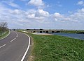
 A1 dual carriageway, Astwick, Beds - geograph.org.uk - 190347.jpg 640 × 480; 333 KB
-
 A14 road and farmland, Oakington, Cambs - geograph.org.uk - 89368.jpg 640 × 480; 293 KB
-
 A14 road, Girton, Cambridge - geograph.org.uk - 87874.jpg 640 × 480; 240 KB
-
 A14 south Cambridgeshire - geograph.org.uk - 90043.jpg 640 × 480; 212 KB
-
 A507 Shefford By-pass, Beds - geograph.org.uk - 63238.jpg 600 × 450; 204 KB
-
 A6 speed camera, Wilstead, Beds - geograph.org.uk - 190882.jpg 640 × 480; 308 KB
-
 A600 High Road, Cotton End, Beds - geograph.org.uk - 190888.jpg 640 × 480; 251 KB
-
 A605 Wisbech Road, Whittlesey, Cambs - geograph.org.uk - 549599.jpg 640 × 480; 313 KB
-
 Abandoned farmland, Frampton Marsh, Lincs - geograph.org.uk - 196499.jpg 640 × 480; 336 KB
-
 Abbey Farm drive, Swineshead, Lincs - geograph.org.uk - 132450.jpg 640 × 480; 506 KB
-
 Abbotsley Brook, Abbotsley, Cambs - geograph.org.uk - 401462.jpg 640 × 482; 144 KB
-
 Across the Medway, East Farleigh, Kent - geograph.org.uk - 187913.jpg 640 × 480; 345 KB
-
-
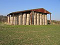
 Airship hangars, Cardington, Beds - geograph.org.uk - 386264.jpg 640 × 480; 247 KB
-
 Alder swamp, Broad Fen, Dilham, Norfolk - geograph.org.uk - 315278.jpg 640 × 480; 463 KB
-
-
 All Saints' church, Upper Stondon, Beds - geograph.org.uk - 193364.jpg 640 × 480; 263 KB
-
 All Saints' Church, Clifton, Beds - geograph.org.uk - 53259.jpg 640 × 480; 266 KB
-
 All Saints' Church, Eyeworth, Beds - geograph.org.uk - 53039.jpg 640 × 459; 264 KB
-
 All Saints' church, Helhoughton, Norfolk - geograph.org.uk - 123710.jpg 640 × 480; 323 KB
-
 All Saints' church, Sutton, Beds - geograph.org.uk - 174991.jpg 640 × 480; 377 KB
-
 All Saints' Hall, Cottenham, Cambs - geograph.org.uk - 176551.jpg 640 × 480; 288 KB
-

-

-

-
 Allotments, Biggleswade, Beds - geograph.org.uk - 190349.jpg 640 × 480; 348 KB
-
 Allotments, Silsoe, Beds. - geograph.org.uk - 50041.jpg 640 × 463; 346 KB
-
 Ancient Earthworks below Pulloxhill, Beds - geograph.org.uk - 64354.jpg 600 × 450; 300 KB
-
 Approach to Ashton, Peterborough - geograph.org.uk - 106300.jpg 640 × 480; 341 KB
-
 Approach to Chapel End, Cardington, Beds - geograph.org.uk - 386609.jpg 640 × 480; 253 KB
-
 Approaching Biggleswade, Beds - geograph.org.uk - 52426.jpg 640 × 480; 264 KB
-
 Arbury Court, Cambridge - geograph.org.uk - 62338.jpg 640 × 480; 385 KB
-

-
-
 Ashby by Partney parish church, Lincs - geograph.org.uk - 86060.jpg 600 × 406; 300 KB
-
 Ashby-de-la-Zouch Canal, Dadlington, Leics - geograph.org.uk - 84525.jpg 600 × 450; 256 KB
-
 Ashton, Peterborough, village sign - geograph.org.uk - 106298.jpg 640 × 480; 339 KB
-
 Ashwell & Morden Station.jpg 640 × 480; 300 KB
-
 B1093 Benwick Road, Whittlesey, Cambs - geograph.org.uk - 548242.jpg 640 × 480; 266 KB
-
 Bainton Green level crossing, Peterborough - geograph.org.uk - 87492.jpg 640 × 480; 258 KB
-
 Bainton parish church, Peterborough - geograph.org.uk - 94753.jpg 640 × 480; 442 KB
-
 Bales of wheat straw, Laughton, Lincs - geograph.org.uk - 227505.jpg 640 × 480; 295 KB
-
 Bales of wheat straw, Sutton, Cambs - geograph.org.uk - 227322.jpg 640 × 480; 287 KB
-
 Baptist Chapel, Stondon, Beds - geograph.org.uk - 217331.jpg 640 × 480; 162 KB
-
 Baptist Church, Maulden, Beds - geograph.org.uk - 190360.jpg 640 × 480; 289 KB
-
 Barbridge Farmhouse, Swineshead, Lincs - geograph.org.uk - 132796.jpg 640 × 480; 334 KB
-

-
 Barton parish church, Cambs - geograph.org.uk - 63202.jpg 600 × 450; 291 KB
-
 Baston Fen Nature Reserve, Lincs - geograph.org.uk - 106144.jpg 640 × 480; 256 KB
-
 Baston, Hudsons Mill.jpg 640 × 480; 307 KB
-

-

-
 Benwick Goods Railway.jpg 640 × 480; 277 KB
-
 Benwick Road, Whittlesey, Cambs - geograph.org.uk - 548464.jpg 640 × 480; 271 KB
-
 Biggleswade Cemetery, Beds - geograph.org.uk - 175001.jpg 640 × 480; 325 KB
-
 Biggleswade railway station, Beds - geograph.org.uk - 172173.jpg 640 × 480; 327 KB
-
 St Andrew's, Biggleswade.jpg 640 × 480; 297 KB
-
 Black Drove Farm, Baston Fen, Lincs - geograph.org.uk - 106152.jpg 640 × 480; 282 KB
-
-

-
 Black Horse public house, Maulden, Beds - geograph.org.uk - 190381.jpg 640 × 464; 243 KB
-
 Black House Farm, Bourne South Fen, Lincs - geograph.org.uk - 453415.jpg 640 × 480; 307 KB
-

-
 Blunham Road, Chalton, Beds - geograph.org.uk - 386794.jpg 640 × 451; 315 KB
-
 Bog oaks, Woodwalton Fen, Cambs - geograph.org.uk - 257736.jpg 640 × 480; 287 KB
-
 Boneashe Lane, Platt, Kent - geograph.org.uk - 239796.jpg 640 × 480; 396 KB
-
 Boston Grammar School, Lincs - geograph.org.uk - 64374.jpg 600 × 450; 248 KB
-
-
 Bridge Farm, Drayton, Somerset - geograph.org.uk - 133846.jpg 640 × 463; 237 KB
-

-
-
 Bridge over the counter drain at Tongue End.jpg 640 × 480; 267 KB
-

-

-
 Bridge over the Welland, Spalding, Lincs - geograph.org.uk - 132836.jpg 640 × 480; 288 KB
-

-
 Brook Farmhouse, Swineshead, Beds - geograph.org.uk - 1553639.jpg 640 × 480; 279 KB
-
 Brown's Drove, Swineshead, Lincs - geograph.org.uk - 132215.jpg 640 × 480; 343 KB
-

-
 Holy Cross parish church, Bury, Cambs - geograph.org.uk - 153256.jpg 640 × 480; 253 KB
-

-
 Cainhoe Manor Farm, Gravenhurst, Beds - geograph.org.uk - 194242.jpg 640 × 480; 278 KB
-
 Cambers Drove, Whittlesey, Cambs - geograph.org.uk - 153209.jpg 640 × 480; 272 KB
-
 Cambridge Crematorium - geograph.org.uk - 90044.jpg 640 × 480; 403 KB
-

-
 Cat's Water Drain.jpg 640 × 480; 393 KB
-
 Chequers pub, Sutton, Cambs - geograph.org.uk - 226940.jpg 640 × 480; 246 KB
-

-
 Cherry Tree Cottage, Maxey, Peterborough - geograph.org.uk - 243928.jpg 640 × 480; 298 KB
-
 Chesterton Road and River Cam, Cambridge - geograph.org.uk - 95785.jpg 640 × 480; 276 KB
-

-
 Church and War Memorial, Silsoe, Beds - geograph.org.uk - 50076.jpg 640 × 480; 275 KB
-
 Church End Road, Haynes, Beds - geograph.org.uk - 174973.jpg 640 × 480; 323 KB
-
 Church Green, Ramsey, Cambs - geograph.org.uk - 153254.jpg 640 × 480; 300 KB
-
 Church of St Andrew, Ufford, Peterborough - geograph.org.uk - 94741.jpg 640 × 480; 230 KB
-
 Church of St Helena, Willoughby, Lincs - geograph.org.uk - 49744.jpg 640 × 480; 359 KB
-
-

-
 Church St Lopen.jpg 640 × 480; 319 KB
-
 Clay Lake road junction, Spalding, Lincs - geograph.org.uk - 172640.jpg 640 × 480; 323 KB
-
 Clophill village green and High St, Beds - geograph.org.uk - 64559.jpg 600 × 450; 207 KB
-
 Clough Bridge, Gosberton Clough, Lincs - geograph.org.uk - 259146.jpg 640 × 480; 397 KB
-
 Colkirk St Mary parish church, Norfolk - geograph.org.uk - 123698.jpg 640 × 480; 341 KB
-

-
 College Farm, Swineshead, Lincs - geograph.org.uk - 132206.jpg 640 × 480; 286 KB
-
 Common Farm, Comberton, Cambs - geograph.org.uk - 98689.jpg 640 × 480; 237 KB
-

-
-
 Converted oast houses, Comp, Offham, Kent - geograph.org.uk - 258769.jpg 640 × 480; 304 KB
-
 Cople Road, Cardington, Beds - geograph.org.uk - 386625.jpg 640 × 480; 87 KB
-
 Corrugated metal roof, Rampton, Cambs - geograph.org.uk - 176181.jpg 640 × 480; 265 KB
-
-
 Cottage on Mill Road, Stanford, Beds - geograph.org.uk - 171204.jpg 640 × 442; 411 KB
-
-
 Cottages, Eyeworth, Beds - geograph.org.uk - 168483.jpg 640 × 480; 284 KB
-
 Cottages, Haynes Church End, Beds - geograph.org.uk - 174140.jpg 640 × 480; 295 KB
-
 Cotton Hall, Frampton, Lincs - geograph.org.uk - 195582.jpg 640 × 480; 294 KB
-
 Council Houses, Surfleet, Lincs - geograph.org.uk - 172655.jpg 640 × 480; 294 KB
-

-
 Country road, Weasenham St Peter, Norfolk - geograph.org.uk - 123717.jpg 640 × 480; 244 KB
-
 Covenham St Bartholomew church, Lincs - geograph.org.uk - 49097.jpg 640 × 480; 336 KB
-
 Cowage Wood, Hilmarton, Wilts - geograph.org.uk - 698320.jpg 640 × 480; 503 KB
-
 Cowbit village sign - geograph.org.uk - 132944.jpg 640 × 480; 276 KB
-
 Cowbit Wash Barrier Bank, Lincs - geograph.org.uk - 51870.jpg 640 × 480; 189 KB
-
 Cowbit windmill, Lincs - geograph.org.uk - 172561.jpg 640 × 480; 302 KB
-
 Crafts Way, Bar Hill, Cambs - geograph.org.uk - 89336.jpg 640 × 480; 333 KB
-

-

-

-
 Croyland Abbey, Crowland, Lincs - geograph.org.uk - 51869.jpg 640 × 480; 231 KB
-
 Croyland Benedictine Abbey, Lincs - geograph.org.uk - 51868.jpg 480 × 640; 227 KB
-

-

-

-
 Derelict pub, Baston Fen, Lincs - geograph.org.uk - 106163.jpg 640 × 480; 249 KB
-

-

-
 Detail of village sign, Swineshead, Lincs - geograph.org.uk - 645946.jpg 480 × 640; 387 KB
-
 Distributary of the River Welland - geograph.org.uk - 87497.jpg 640 × 480; 402 KB
-

-
 Donington High Bridge, Donington, Lincs - geograph.org.uk - 227333.jpg 640 × 480; 262 KB
-
 Donington South Ing, Donington, Lincs - geograph.org.uk - 217008.jpg 640 × 480; 193 KB
-
 Dover Street, Maidstone, Kent - geograph.org.uk - 236648.jpg 640 × 480; 314 KB
-
 Downing House, Lower Road, Croydon, Cambs - geograph.org.uk - 219290.jpg 640 × 480; 294 KB
-
 Dowsby Fen Pumping Station, Lincs - geograph.org.uk - 243939.jpg 640 × 480; 318 KB
-

-

-
-
-

-
 Earthworm stone mounds - geograph.org.uk - 724985.jpg 640 × 480; 478 KB
-
 East coast main line, Biggleswade, Beds - geograph.org.uk - 168486.jpg 640 × 480; 357 KB
-
 East coast main line, Tallington, Lincs - geograph.org.uk - 94811.jpg 640 × 480; 277 KB
-
 East Raynham to Colkirk road, Norfolk - geograph.org.uk - 123694.jpg 640 × 480; 279 KB
-
 Eastville parish church, Lincs - geograph.org.uk - 86061.jpg 600 × 409; 270 KB
-

-
 Eaudike Road, Donington Eaudike, Lincs - geograph.org.uk - 700995.jpg 640 × 480; 310 KB
-
-
 Electricity sub-station, Histon, Cambs - geograph.org.uk - 95750.jpg 640 × 480; 334 KB
-
-
 Elsworth Mill, Elsworth, Cambs - geograph.org.uk - 402244.jpg 640 × 480; 349 KB
-
 Emery Lane, Boston, Lincs - geograph.org.uk - 597747.jpg 480 × 640; 307 KB
-
 Entering Swineshead, Beds - geograph.org.uk - 1553634.jpg 640 × 480; 420 KB
-

-
 Entrance to Cottenham, Cambs - geograph.org.uk - 175802.jpg 640 × 480; 280 KB
-
 Entrance to Deadman's Cross, Haynes, Beds - geograph.org.uk - 174989.jpg 640 × 480; 275 KB
-
 Entrance to Ickleton village, Cambs - geograph.org.uk - 153268.jpg 640 × 480; 250 KB
-
 Entrance to Ramsey Mereside, Cambs - geograph.org.uk - 153232.jpg 640 × 480; 241 KB
-
-

-

-
 Eye parish church, Peterborough - geograph.org.uk - 84455.jpg 600 × 450; 138 KB
-

-
 Farm track and ditch, Moulton Fen, Lincs - geograph.org.uk - 1480517.jpg 640 × 480; 371 KB
-

-

-
 Farmland in West Clyst north of Exeter - geograph.org.uk - 725006.jpg 640 × 480; 415 KB
-
 Farmland near Bicker Bar, Lincs - geograph.org.uk - 84502.jpg 600 × 421; 323 KB
-
 Farmland S of Hardwick, Cambs - geograph.org.uk - 98757.jpg 640 × 480; 301 KB
-
-
 Farmland view towards Higham Gobion, Beds - geograph.org.uk - 194206.jpg 640 × 480; 293 KB
-
 Farmland view, Wendy, Cambs - geograph.org.uk - 104725.jpg 640 × 474; 322 KB
-
 Farmland, Baston Fen, Lincs - geograph.org.uk - 106158.jpg 640 × 480; 305 KB
-
 Farmland, Comberton, Cambs - geograph.org.uk - 98739.jpg 640 × 480; 281 KB
-
 Farmland, Grunty Fen, Cambs - geograph.org.uk - 231447.jpg 640 × 480; 280 KB
-
 Farmland, New Road, Melbourn, Cambs - geograph.org.uk - 53050.jpg 640 × 480; 277 KB
-
 Fen Bridge, Crowland, Lincs - geograph.org.uk - 155153.jpg 640 × 470; 288 KB
-
 Fen Drove, Hubbert's Bridge, Lincs - geograph.org.uk - 227572.jpg 640 × 480; 294 KB
-
 Fishmere End Road, Kirton, Lincs - geograph.org.uk - 172970.jpg 640 × 480; 313 KB
-
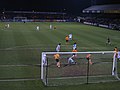 Floodlit match, Abbey Stadium, Cambridge - geograph.org.uk - 52722.jpg 640 × 480; 286 KB
-

-

-


