Category:Images by Roger Davies

Media in category "Images by Roger Davies"
The following 200 files are in this category, out of 1,209 total.
(previous page) (next page)-
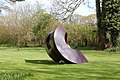 "Friendship" sculpture at Hellens - geograph.org.uk - 767494.jpg 640 × 426; 112 KB
-

-

-
-
 A converted barn at Longworth Bridge - geograph.org.uk - 1012522.jpg 640 × 426; 82 KB
-
 A field of brassicas - geograph.org.uk - 747408.jpg 640 × 426; 125 KB
-
 A hybrid technology bus at Heathrow airport - geograph.org.uk - 1841362.jpg 3,008 × 2,000; 1.15 MB
-
-

-

-

-

-
 A very wet A82 at Bridge of Orchy - geograph.org.uk - 784522.jpg 640 × 426; 59 KB
-
 A40 east of Ross-on-Wye - geograph.org.uk - 971277.jpg 640 × 426; 67 KB
-

-
 A838 near Achfary - geograph.org.uk - 1261686.jpg 640 × 426; 57 KB
-
 A838 near Durness - geograph.org.uk - 1261705.jpg 640 × 426; 64 KB
-
-

-
 A896 in Lochcarron - geograph.org.uk - 1264305.jpg 640 × 426; 66 KB
-
 Abbey Terrace Winchcombe in 1973 - geograph.org.uk - 754589.jpg 422 × 640; 127 KB
-
 Achfary - geograph.org.uk - 1261690.jpg 640 × 426; 56 KB
-
 Admiring the view^ - geograph.org.uk - 791457.jpg 640 × 426; 86 KB
-
 Aerial walkway at Ashleworth Quay - geograph.org.uk - 775252.jpg 640 × 426; 128 KB
-

-

-

-
 Alderton War Memorial - geograph.org.uk - 969566.jpg 640 × 426; 107 KB
-
 All ashore at the Lower Lode Inn^ - geograph.org.uk - 785545.jpg 426 × 640; 95 KB
-
 All Saint's Church, Brockhampton - geograph.org.uk - 1434628.jpg 640 × 426; 81 KB
-
-
 All Saint's Church, Marcham - geograph.org.uk - 1289935.jpg 640 × 426; 82 KB
-
 All Saints Church, Longhope - geograph.org.uk - 808694.jpg 640 × 426; 68 KB
-
 Allotments at Beer, Devon - geograph.org.uk - 886536.jpg 640 × 426; 91 KB
-
 Allotments at Gorsley Common - geograph.org.uk - 1550865.jpg 640 × 426; 120 KB
-

-

-

-

-
 Anti-tank cylinders - geograph.org.uk - 1441828.jpg 640 × 426; 97 KB
-

-

-

-
 Applecross Bay - geograph.org.uk - 1256739.jpg 640 × 426; 90 KB
-

-
 Arable land near Stanway Hill - geograph.org.uk - 1292738.jpg 640 × 426; 74 KB
-
 Arable land near Stoke Orchard - geograph.org.uk - 759717.jpg 640 × 426; 64 KB
-

-
 Ardvreck Castle and Loch Assynt - geograph.org.uk - 1260780.jpg 640 × 426; 69 KB
-
 Ascending Bealach na Ba pass - geograph.org.uk - 1264281.jpg 640 × 426; 51 KB
-
 Ashleworth Quay - geograph.org.uk - 775280.jpg 640 × 426; 68 KB
-

-
 Auch viaduct below Beinn Dorain - geograph.org.uk - 720629.jpg 640 × 426; 67 KB
-
 Australian Red Indian encampment^ - geograph.org.uk - 1456056.jpg 640 × 426; 55 KB
-

-

-
 B4477 approaches the Witney by-pass - geograph.org.uk - 1549880.jpg 640 × 426; 71 KB
-
 B869 in Drumbeg - geograph.org.uk - 1260819.jpg 640 × 426; 72 KB
-

-
 Renovated lych gate at St James', Badsey - geograph.org.uk - 803497.jpg 640 × 426; 115 KB
-
 St James' church, Badsey in May - geograph.org.uk - 803506.jpg 426 × 640; 77 KB
-
 Balnakeil Bay - geograph.org.uk - 1254814.jpg 640 × 426; 77 KB
-
 Baptist chapel at Henllan - geograph.org.uk - 973304.jpg 640 × 426; 102 KB
-
 Barber's Bridge monument - geograph.org.uk - 790745.jpg 426 × 640; 84 KB
-
 Barley growing near Fishpool Hill - geograph.org.uk - 1434406.jpg 640 × 426; 84 KB
-
 Barn at Home Farm near Welsh Bicknor - geograph.org.uk - 1446102.jpg 640 × 426; 57 KB
-
 Barn at Whittlebury Farm - geograph.org.uk - 1434577.jpg 640 × 426; 107 KB
-
 Barn conversion at Brockhampton - geograph.org.uk - 1434637.jpg 640 × 426; 65 KB
-

-

-
 Barn Lane near Corse - geograph.org.uk - 1528289.jpg 640 × 426; 53 KB
-
 Barn near Stanway House - geograph.org.uk - 1292721.jpg 640 × 426; 68 KB
-
 Bastion in Hereford's medieval city walls (Geograph 2598944 by Roger Davies).jpg 4,752 × 3,168; 5.86 MB
-
-
 Beach defences at Lydney harbour - geograph.org.uk - 1519239.jpg 640 × 426; 113 KB
-
 Beach huts at Charmouth - geograph.org.uk - 886449.jpg 640 × 426; 82 KB
-
 Beach huts on Seaton seafront - geograph.org.uk - 886338.jpg 640 × 426; 59 KB
-
 Beauchamp Arms at Dymock - geograph.org.uk - 768126.jpg 640 × 426; 61 KB
-

-

-

-
 Bettiscombe village hall - geograph.org.uk - 886575.jpg 640 × 426; 78 KB
-
 Blakeney Post Office - geograph.org.uk - 1518442.jpg 640 × 426; 50 KB
-
-
 Blunsdon Methodist Chapel - geograph.org.uk - 967129.jpg 640 × 426; 61 KB
-
 Boathouse at Long Bridges - geograph.org.uk - 1324134.jpg 640 × 426; 61 KB
-
 Boathouses on the Isis - geograph.org.uk - 1324143.jpg 640 × 426; 58 KB
-
-

-
-

-

-
 Bream Cenotaph restored in 2002 - geograph.org.uk - 1518686.jpg 640 × 426; 57 KB
-
 Bretforton post office - geograph.org.uk - 803570.jpg 640 × 426; 94 KB
-
 Bridge over M5 near Stoke Orchard - geograph.org.uk - 761586.jpg 640 × 426; 51 KB
-

-
 Bridge over the Ell Brook at Highleadon - geograph.org.uk - 789610.jpg 640 × 426; 109 KB
-

-

-

-
 Bridge repairs in Gretton - geograph.org.uk - 1526031.jpg 640 × 426; 74 KB
-
 Bridges over the River Gavenny - geograph.org.uk - 780282.jpg 640 × 426; 95 KB
-
 St Bridget's Church, Bridstow - geograph.org.uk - 808856.jpg 640 × 426; 92 KB
-

-

-

-
 Brockhampton Parish Hall built 1921 - geograph.org.uk - 1434641.jpg 640 × 426; 64 KB
-
 Bromsash crossroads - geograph.org.uk - 971179.jpg 640 × 426; 58 KB
-
 Bromsash garden centre - geograph.org.uk - 971198.jpg 640 × 426; 62 KB
-
 Bus shelter at Welsh Newton - geograph.org.uk - 931754.jpg 640 × 426; 84 KB
-
-

-
 Bus shelter near St Briavels - geograph.org.uk - 1519117.jpg 640 × 426; 57 KB
-

-
 Canal tow path near Fretherne Bridge - geograph.org.uk - 792907.jpg 640 × 426; 89 KB
-

-
-

-
 Capel-y-ffin telephone box - geograph.org.uk - 973432.jpg 640 × 426; 107 KB
-
 Capler Wood picnic site - geograph.org.uk - 1434347.jpg 640 × 426; 120 KB
-
 Car Rally at the Rising Sun in Pandy - geograph.org.uk - 973140.jpg 640 × 426; 73 KB
-

-
-
 Cattle grazing near Mordiford Bridge - geograph.org.uk - 1453966.jpg 640 × 426; 78 KB
-
-
 Cattle grid near Apperley Court - geograph.org.uk - 775312.jpg 640 × 426; 91 KB
-
 Cattle grid near Drumbeg - geograph.org.uk - 1260851.jpg 640 × 426; 79 KB
-

-
 Central Vehicle Depot at Ashchurch - geograph.org.uk - 761714.jpg 640 × 426; 38 KB
-
 Cereals growing near Windrush - geograph.org.uk - 802659.jpg 640 × 426; 100 KB
-

-
 Charmouth beach during a July storm - geograph.org.uk - 886352.jpg 640 × 426; 58 KB
-

-
-

-

-
 Church Farm, St Briavels - geograph.org.uk - 1519138.jpg 640 × 426; 76 KB
-
 Church Green, Badby - geograph.org.uk - 1525266.jpg 640 × 426; 86 KB
-
 Church of St Barnabas at Snowshill - geograph.org.uk - 846778.jpg 640 × 426; 82 KB
-

-
 Church of St Martin at Cwmyoy - geograph.org.uk - 973198.jpg 640 × 426; 113 KB
-

-

-

-

-

-
 Church of St Mary the Virgin, Badby - geograph.org.uk - 1525263.jpg 640 × 426; 79 KB
-
-

-

-
 Church of St Saviour, Redbrook - geograph.org.uk - 1499382.jpg 640 × 426; 97 KB
-
-
-
 Churchyard at Pentre near Llangwm - geograph.org.uk - 799926.jpg 640 × 426; 87 KB
-
 Clashnessie Bay - geograph.org.uk - 1254931.jpg 640 × 426; 75 KB
-

-
 Cleeve Road in Gotherington - geograph.org.uk - 775577.jpg 640 × 426; 90 KB
-
 Cliffs on Lundy Island's east coast - geograph.org.uk - 3113864.jpg 4,752 × 3,168; 2.16 MB
-
 Coastal defences near Leasowe lighthouse-by-Roger-Davies.jpg 640 × 426; 37 KB
-

-
 Colcombe House near Hampton Bishop - geograph.org.uk - 1456103.jpg 640 × 426; 76 KB
-
 Combining between the heavy showers - geograph.org.uk - 950695.jpg 640 × 426; 75 KB
-
 Combining near Kintbury - geograph.org.uk - 967382.jpg 640 × 426; 65 KB
-

-
 Commando Memorial at Spean Bridge - geograph.org.uk - 1258387.jpg 426 × 640; 54 KB
-

-

-
 Connah's Quay Power Station.jpg 640 × 426; 50 KB
-

-
 Coombe Hill Nature Reserve - geograph.org.uk - 774614.jpg 640 × 426; 97 KB
-
 Cornfield near Usk - geograph.org.uk - 907290.jpg 640 × 426; 77 KB
-
 Corran Ferry - geograph.org.uk - 1258438.jpg 640 × 426; 49 KB
-
 Cotswold lane east of Sudeley Hill - geograph.org.uk - 785923.jpg 640 × 426; 108 KB
-

-
 Cotswold Way above Wood Stanway - geograph.org.uk - 1292782.jpg 640 × 426; 63 KB
-

-
 Cotswold Way at Stumps Cross - geograph.org.uk - 1292794.jpg 640 × 426; 131 KB
-
 Cotswold Way at Upper Coscombe - geograph.org.uk - 1292796.jpg 640 × 426; 41 KB
-
 Cotswold Way below Belas Knap in April - geograph.org.uk - 759779.jpg 640 × 426; 138 KB
-
 Cotswold Way near Stanway - geograph.org.uk - 916425.jpg 640 × 426; 118 KB
-
 Cotswold Way near Stumps Cross - geograph.org.uk - 1292791.jpg 640 × 426; 70 KB
-
 Cottages at Crossway - geograph.org.uk - 1009794.jpg 640 × 426; 82 KB
-
 Cottages at Little Bedwyn - geograph.org.uk - 801790.jpg 640 × 426; 90 KB
-
 Cotton's Farm near Wormington - geograph.org.uk - 803140.jpg 640 × 426; 86 KB
-

-
 Country lane near Llandevenny - geograph.org.uk - 806406.jpg 640 × 426; 84 KB
-
 Country road near Okle Green - geograph.org.uk - 789486.jpg 640 × 426; 86 KB
-
 Court Farm at Pontrilas - geograph.org.uk - 973119.jpg 640 × 426; 77 KB
-
 Court Farm at Sollers Hope - geograph.org.uk - 1434583.jpg 640 × 426; 78 KB
-

-
 Coventry Pool Meadow bus station - geograph.org.uk - 2444410.jpg 3,008 × 2,000; 1.53 MB
-
 Cromwell's Monument in Beckbury Camp - geograph.org.uk - 1292806.jpg 426 × 640; 130 KB
-

-
 Cropredy lock on the Oxford Canal - geograph.org.uk - 1525233.jpg 640 × 426; 98 KB
-
-
 Cross roads at St Owen's Cross - geograph.org.uk - 780189.jpg 640 × 426; 52 KB
-
-
 Crossroads at Ready Token - geograph.org.uk - 776946.jpg 640 × 426; 77 KB
-
 Crossroads in Fyfield - geograph.org.uk - 1289931.jpg 640 × 426; 57 KB
-


.jpg)


_Lowbands_-_geograph.org.uk_-_1528365.jpg)


