Category:Images by Stuart Buchan

Media in category "Images by Stuart Buchan"
The following 200 files are in this category, out of 741 total.
(previous page) (next page)-
 A 246 near West Horsley - geograph.org.uk - 69602.jpg 640 × 481; 158 KB
-
 A2030 - geograph.org.uk - 36014.jpg 640 × 481; 103 KB
-
 A31 roundabout, St. Leonards, Dorset - geograph.org.uk - 84702.jpg 640 × 481; 98 KB
-
 A338 to Salisbury - geograph.org.uk - 213204.jpg 640 × 481; 76 KB
-
 A35 - geograph.org.uk - 59235.jpg 640 × 481; 151 KB
-
 A35 minor road junction - geograph.org.uk - 171621.jpg 640 × 481; 94 KB
-
 A350 - geograph.org.uk - 60725.jpg 640 × 481; 115 KB
-
 A358 road junction - geograph.org.uk - 171895.jpg 640 × 481; 118 KB
-
 Access road to Barford Farm - geograph.org.uk - 156265.jpg 640 × 481; 80 KB
-
 Ackling Dyke (Roman Road) - geograph.org.uk - 208473.jpg 640 × 481; 154 KB
-
 Ackling Dyke - geograph.org.uk - 208470.jpg 640 × 481; 134 KB
-
 AFV Gunnery School - geograph.org.uk - 25431.jpg 640 × 481; 79 KB
-

-
 Alderholt Clubhouse - geograph.org.uk - 140571.jpg 640 × 481; 88 KB
-
 Aldi, Springbourne - geograph.org.uk - 32374.jpg 640 × 481; 97 KB
-
 All Saints Broad Chalke.jpg 640 × 481; 133 KB
-
 All Saints Church Chalbury - geograph.org.uk - 18949.jpg 640 × 481; 119 KB
-
 Almshouses, Ashbourne - geograph.org.uk - 17932.jpg 640 × 481; 102 KB
-
 Almshouses, Ringwood - geograph.org.uk - 10779.jpg 640 × 481; 136 KB
-
 Amie's Corner, New Forest - geograph.org.uk - 63803.jpg 640 × 481; 129 KB
-
 Anderwood Car Park, New Forest - geograph.org.uk - 19449.jpg 640 × 481; 155 KB
-
 Anderwood Inlosure, New Forest - geograph.org.uk - 19447.jpg 640 × 481; 181 KB
-
 Ashley Farm, St Leonards and St Ives - geograph.org.uk - 181319.jpg 640 × 481; 115 KB
-
 Ashley Heath shops - geograph.org.uk - 10638.jpg 640 × 481; 169 KB
-
 Ashley Heath Station.jpg 640 × 481; 182 KB
-
 Avebury Manor.jpg 640 × 426; 88 KB
-
 Avon Valley Path - geograph.org.uk - 21815.jpg 640 × 481; 158 KB
-
 Avon Valley Path - geograph.org.uk - 75312.jpg 640 × 481; 118 KB
-
 Avon Valley Path - geograph.org.uk - 75313.jpg 640 × 481; 89 KB
-
 B3058, Bashley, Hampshire - geograph.org.uk - 91169.jpg 640 × 481; 113 KB
-
 B3134 road junction - geograph.org.uk - 146991.jpg 640 × 481; 67 KB
-
 Backley Bottom - geograph.org.uk - 732282.jpg 640 × 480; 110 KB
-
 Bagnum Farm - geograph.org.uk - 10067.jpg 481 × 640; 159 KB
-
 Barton on Sea - geograph.org.uk - 109344.jpg 640 × 481; 154 KB
-
 Bateman's 1.jpg 640 × 480; 111 KB
-
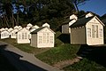
 Beach Huts - geograph.org.uk - 10362.jpg 640 × 481; 106 KB
-
 Bickton Mill - geograph.org.uk - 61358.jpg 640 × 481; 146 KB
-
 Bigsburn Hill, New Forest - geograph.org.uk - 35440.jpg 640 × 481; 204 KB
-
 Birches Copse, Verwood, Dorset - geograph.org.uk - 87718.jpg 640 × 481; 161 KB
-
 Bleak Hill, Hampshire - geograph.org.uk - 140572.jpg 640 × 481; 130 KB
-
 Boscombe Beach - geograph.org.uk - 36850.jpg 481 × 640; 90 KB
-
 Boscombe Pier, Dorset - geograph.org.uk - 1074864.jpg 480 × 640; 58 KB
-
 Church, Bournemouth - geograph.org.uk - 149555.jpg 640 × 481; 110 KB
-
 Crematorium and North Cemetery - geograph.org.uk - 176459.jpg 640 × 481; 99 KB
-

-
 Bournemouth International Airport - geograph.org.uk - 87066.jpg 640 × 481; 113 KB
-
 Bournemouth Pier - geograph.org.uk - 8291.jpg 640 × 481; 112 KB
-
 Bournemouth Sports Club - geograph.org.uk - 87074.jpg 640 × 481; 145 KB
-

-
 Bransbury Park, Eastney - geograph.org.uk - 36010.jpg 640 × 481; 109 KB
-
 St. Mary's Church, Bransgore - geograph.org.uk - 35096.jpg 640 × 481; 114 KB
-
 Bransgore shops.jpg 640 × 481; 124 KB
-
 Bratley Wood - geograph.org.uk - 732268.jpg 640 × 480; 141 KB
-
 Upper Street, Breamore - geograph.org.uk - 160746.jpg 640 × 481; 103 KB
-
 Breeze Hill, Melbury Abbas - geograph.org.uk - 92979.jpg 640 × 481; 86 KB
-
 Briantspuddle, Dorset - geograph.org.uk - 25549.jpg 640 × 481; 124 KB
-
 Brownhill Inclosure, New Forest - geograph.org.uk - 37759.jpg 640 × 481; 174 KB
-
 Brownhill Inclosure, New Forest - geograph.org.uk - 37795.jpg 640 × 481; 174 KB
-
 Bulmoor Cross, Devon - geograph.org.uk - 172202.jpg 640 × 481; 120 KB
-
 Burley Street Stores - geograph.org.uk - 27768.jpg 640 × 481; 114 KB
-
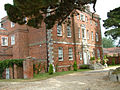 Burton Hall, Dorset - geograph.org.uk - 22588.jpg 640 × 482; 165 KB
-
 Burton, Dorset - geograph.org.uk - 74345.jpg 640 × 481; 115 KB
-
 Camping and Caravan Site, Verwood, Dorset - geograph.org.uk - 87715.jpg 640 × 481; 112 KB
-
 Canford Cliffs Chine - geograph.org.uk - 1092434.jpg 640 × 426; 84 KB
-
 Canford Heath, Dorset - geograph.org.uk - 78522.jpg 640 × 481; 151 KB
-
 Car Park, Godshill Inclosure - geograph.org.uk - 183886.jpg 640 × 481; 113 KB
-
 Caravan Site Entrance - geograph.org.uk - 204311.jpg 640 × 481; 89 KB
-
 Caravan Site, Monckton Wyld - geograph.org.uk - 171893.jpg 640 × 481; 125 KB
-
 Carsington Reservoir - geograph.org.uk - 17901.jpg 640 × 481; 123 KB
-
 Carsington Reservoir - geograph.org.uk - 17903.jpg 640 × 481; 117 KB
-
 Carsington Reservoir - geograph.org.uk - 17907.jpg 640 × 481; 93 KB
-
 Castleman Trail, Crow, Ringwood - geograph.org.uk - 395963.jpg 640 × 480; 146 KB
-
 Castleman Trailway - geograph.org.uk - 10632.jpg 640 × 481; 167 KB
-
 Castlepoint - geograph.org.uk - 20532.jpg 640 × 481; 122 KB
-
 Cemetery, St Leonards, Whitsbury - geograph.org.uk - 187155.jpg 640 × 481; 124 KB
-
 Charlton Cross, Devon - geograph.org.uk - 171629.jpg 640 × 481; 73 KB
-

-
 Chewton Glen Hotel, Hampshire - geograph.org.uk - 22589.jpg 640 × 479; 91 KB
-
 Chicken Farming, Alderholt - geograph.org.uk - 162095.jpg 640 × 481; 109 KB
-
 Christmas ruined, Godwinscroft - geograph.org.uk - 92460.jpg 640 × 481; 134 KB
-

-
 Cloister, Battle Abbey - geograph.org.uk - 442065.jpg 640 × 480; 125 KB
-
 Coastguard Station, Hengistbury Head - geograph.org.uk - 10330.jpg 640 × 481; 64 KB
-
 Cold War Museum, RAF Cosford - geograph.org.uk - 477001.jpg 640 × 480; 62 KB
-
 Common Plantation, Alderbury - geograph.org.uk - 206836.jpg 640 × 481; 160 KB
-
 Compton Martin, Somerset - geograph.org.uk - 146992.jpg 640 × 481; 87 KB
-
 Corfe Castle Station - geograph.org.uk - 1021357.jpg 640 × 427; 70 KB
-
 Coronation Corner, Axmouth - geograph.org.uk - 171898.jpg 640 × 481; 92 KB
-
 Cowgrove, Dorset - geograph.org.uk - 150891.jpg 640 × 481; 75 KB
-
 Crichel House access - geograph.org.uk - 18943.jpg 640 × 481; 121 KB
-
 Crown Inn, Bransgore - geograph.org.uk - 35087.jpg 640 × 481; 107 KB
-
 Cull-peppers Dish - geograph.org.uk - 25437.jpg 481 × 640; 176 KB
-
 Danestream Farm Shop - geograph.org.uk - 64429.jpg 640 × 481; 98 KB
-
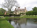
 Dean's Court, Wimborne - geograph.org.uk - 394081.jpg 640 × 480; 131 KB
-
 Devil's Dyke - geograph.org.uk - 1762047.jpg 427 × 640; 43 KB
-
 Dismantled Railway, Three Legged Cross - geograph.org.uk - 108550.jpg 640 × 481; 177 KB
-
 Disused Rifle Range - geograph.org.uk - 75900.jpg 640 × 481; 108 KB
-
 Donkey Bottom, Burton Common, Hampshire - geograph.org.uk - 92465.jpg 640 × 481; 153 KB
-
 Dorset Lake Avenue, Lilliput, Dorset - geograph.org.uk - 78516.jpg 640 × 481; 129 KB
-
 Downhaye, NW of Colyton, Devon - geograph.org.uk - 171906.jpg 640 × 481; 110 KB
-
 Downton, Hampshire - geograph.org.uk - 109207.jpg 640 × 481; 174 KB
-
 Dur Hill Down, New Forest - geograph.org.uk - 37373.jpg 640 × 481; 145 KB
-
 East Howe, Bournemouth - geograph.org.uk - 149550.jpg 640 × 481; 104 KB
-
 Eastney - geograph.org.uk - 36002.jpg 640 × 481; 149 KB
-
 Eastney Beach - geograph.org.uk - 35993.jpg 640 × 481; 136 KB
-
 Edmondsham Church, Dorset - geograph.org.uk - 87721.jpg 640 × 481; 139 KB
-
 Entering Poole - geograph.org.uk - 149541.jpg 640 × 481; 101 KB
-
 Eyeworth Pond, Fritham - geograph.org.uk - 7584.jpg 640 × 481; 119 KB
-
 Farley Church - geograph.org.uk - 206850.jpg 481 × 640; 90 KB
-
 Farley Hospital - geograph.org.uk - 206869.jpg 640 × 481; 99 KB
-
 Farm Activity, Ashwell - geograph.org.uk - 205162.jpg 640 × 481; 75 KB
-
 Farmland near Ashridge Copse - geograph.org.uk - 154945.jpg 640 × 481; 116 KB
-
 Farmland near to Blackpool Corner - geograph.org.uk - 172312.jpg 640 × 481; 124 KB
-
 Farmland near to Chew Valley Lake - geograph.org.uk - 146996.jpg 640 × 481; 96 KB
-
 Farmland, Blackpool Corner, Devon - geograph.org.uk - 171638.jpg 640 × 481; 98 KB
-
 Farmland, Broad Chalke - geograph.org.uk - 88224.jpg 640 × 481; 98 KB
-
 Farmland, Lower Mannington, Dorset - geograph.org.uk - 81847.jpg 640 × 481; 131 KB
-
 Farmland, north of Ashwell - geograph.org.uk - 204300.jpg 640 × 481; 118 KB
-
 Farmland, Ottery St. Mary - geograph.org.uk - 25554.jpg 640 × 481; 125 KB
-
 Farmland, Ringwood - geograph.org.uk - 21823.jpg 640 × 481; 152 KB
-
 Farmland, Sandford - geograph.org.uk - 21820.jpg 640 × 481; 105 KB
-
 Farmland, Tiptoe - geograph.org.uk - 64432.jpg 640 × 481; 138 KB
-
 Farwood Barton, Northleigh, Devon - geograph.org.uk - 171909.jpg 640 × 481; 104 KB
-
 Fields close to Witherington Farm. - geograph.org.uk - 183931.jpg 640 × 481; 158 KB
-
 Figsbury Ring car park - geograph.org.uk - 61355.jpg 640 × 481; 135 KB
-
 Fjordling Smokehouse - geograph.org.uk - 206866.jpg 640 × 480; 66 KB
-
 Flyover A31 - geograph.org.uk - 10629.jpg 640 × 481; 118 KB
-
 Footbridge - Harvest Slade Bottom - geograph.org.uk - 1035843.jpg 640 × 480; 138 KB
-
 Footpath to Brookheath - geograph.org.uk - 160749.jpg 640 × 481; 178 KB
-
 Footpath to Kingston Lacy, Dorset - geograph.org.uk - 156448.jpg 640 × 481; 114 KB
-
 Footpath, Bovey Down, Devon - geograph.org.uk - 172201.jpg 640 × 481; 150 KB
-
 For Sale - geograph.org.uk - 900388.jpg 640 × 426; 69 KB
-
 Ford, Godshill - geograph.org.uk - 183878.jpg 640 × 481; 158 KB
-
 Fordingbridge Sports Ground - geograph.org.uk - 30919.jpg 640 × 481; 82 KB
-
 Fordingbridge, Horseport - geograph.org.uk - 30920.jpg 640 × 481; 111 KB
-
 Forest Farm, Highgate, Devon - geograph.org.uk - 172203.jpg 640 × 481; 141 KB
-
 Fovant Badges, Wiltshire - geograph.org.uk - 92971.jpg 640 × 481; 135 KB
-
 Frampton Arms, Crossways - geograph.org.uk - 25439.jpg 640 × 481; 112 KB
-
 Friden Station - geograph.org.uk - 17538.jpg 640 × 481; 126 KB
-
 Fritham Free Church United 1904 - geograph.org.uk - 9829.jpg 640 × 481; 141 KB
-
 Gotham, Derbyshire - geograph.org.uk - 17544.jpg 640 × 481; 137 KB
-
 Great Chalfield Manor 11.jpg 640 × 426; 102 KB
-
 Grim's Ditch - geograph.org.uk - 187114.jpg 640 × 481; 120 KB
-
 Groyne - geograph.org.uk - 36863.jpg 640 × 481; 94 KB
-
 Guide Hut, Dudsbury, Dorset - geograph.org.uk - 83497.jpg 640 × 481; 83 KB
-
 Gunners Row, Eastney - geograph.org.uk - 36005.jpg 640 × 481; 100 KB
-
 Gussage All Saints Church - geograph.org.uk - 208478.jpg 640 × 481; 110 KB
-
 Hare and Hounds, Sway, New Forest - geograph.org.uk - 37765.jpg 640 × 481; 119 KB
-
 Hart Grove Farm - geograph.org.uk - 171625.jpg 640 × 481; 93 KB
-
 Hatchlands - geograph.org.uk - 69610.jpg 640 × 481; 121 KB
-
 Hincheslea Moor, New Forest - geograph.org.uk - 37770.jpg 640 × 481; 136 KB
-
 St. Michael and all Angels, Hinton - geograph.org.uk - 59512.jpg 640 × 481; 142 KB
-
 Hoburne - Bashley Park - geograph.org.uk - 64313.jpg 640 × 481; 113 KB
-
 Holly Hatch Inclosure - geograph.org.uk - 17430.jpg 640 × 481; 162 KB
-
 Holmsley Campsite - geograph.org.uk - 35105.jpg 640 × 481; 98 KB
-
 Holmsley Railway Station.jpg 640 × 481; 113 KB
-
 Holmsley Ridge - gravel pit - geograph.org.uk - 637075.jpg 640 × 426; 83 KB
-
 Holt Heath, Dorset - geograph.org.uk - 21315.jpg 640 × 481; 96 KB
-
 Honeypot Farm entrance - geograph.org.uk - 64436.jpg 640 × 481; 154 KB
-
 Hoopers Hill, Downton, Hampshire - geograph.org.uk - 109210.jpg 640 × 481; 148 KB
-
 Hordle Cliff, Hampshire - geograph.org.uk - 82425.jpg 640 × 481; 152 KB
-
 Hordle Parish Church - the original site - geograph.org.uk - 413880.jpg 640 × 480; 126 KB
-
 Horton Inn - geograph.org.uk - 18955.jpg 640 × 481; 81 KB
-
 Three Horseshoes Inn, Houghton - geograph.org.uk - 18311.jpg 640 × 481; 104 KB
-
 Houghton Mill, Houghton - geograph.org.uk - 18319.jpg 640 × 481; 138 KB
-
 Hurn Forest - geograph.org.uk - 63080.jpg 640 × 481; 160 KB
-
 Hurst Castle - geograph.org.uk - 19510.jpg 640 × 481; 87 KB
-
 Iford Bridge, Dorset - geograph.org.uk - 138226.jpg 640 × 481; 111 KB
-
 Iford Recreation Ground - geograph.org.uk - 138218.jpg 640 × 481; 68 KB
-
 Industrial Estate, New Milton - geograph.org.uk - 33317.jpg 640 × 481; 110 KB
-
 Industrial Estate, Purewell - geograph.org.uk - 74342.jpg 640 × 481; 93 KB
-
 Ironstone Quarry, Hengistbury Head - geograph.org.uk - 10331.jpg 640 × 481; 139 KB
-
 Jubilee Trail, Dorset - geograph.org.uk - 25542.jpg 640 × 481; 123 KB
-
 Jubilee Trail, Dorset - geograph.org.uk - 25543.jpg 640 × 481; 174 KB
-
 Junction close to Furzehill, Dorset - geograph.org.uk - 110516.jpg 640 × 481; 123 KB
-
 King's Garden, New Forest - geograph.org.uk - 898090.jpg 640 × 480; 72 KB
-
 St. Stephen's, Kingston Lacey, Dorset - geograph.org.uk - 150894.jpg 640 × 481; 123 KB
-
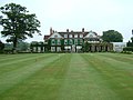
 Kingston Lacy, Dorset - geograph.org.uk - 156449.jpg 640 × 481; 99 KB
-
 Kissing Gate and Public Footpath - geograph.org.uk - 171907.jpg 640 × 481; 141 KB
-
 Lady Wimborne Bridge - geograph.org.uk - 485616.jpg 640 × 480; 129 KB
-
 Lidl, Tricketts Cross - geograph.org.uk - 33311.jpg 640 × 481; 83 KB
-
 Lifting Bridge, Poole, Dorset - geograph.org.uk - 11214.jpg 640 × 481; 116 KB
-
 Litlington, Cambridgeshire - geograph.org.uk - 204293.jpg 640 × 481; 92 KB
-
 Little Sea, Studland - geograph.org.uk - 1021415.jpg 427 × 640; 70 KB
-
 Long Beech Campsite - geograph.org.uk - 58703.jpg 640 × 481; 155 KB
-
 Longcliffe Station - High Peak Trail - geograph.org.uk - 17541.jpg 640 × 481; 114 KB
-
 Longslade Bottom, New Forest - geograph.org.uk - 76004.jpg 640 × 481; 144 KB
-
 Lower Canterton, New Forest - geograph.org.uk - 58709.jpg 640 × 481; 154 KB
-
 Lower Daggons, Alderholt, Dorset - geograph.org.uk - 140570.jpg 640 × 481; 93 KB
-
 Lower Soudley, Forest of Dean - geograph.org.uk - 60727.jpg 640 × 481; 167 KB
-
 Luscombe Valley Local Nature Reserve - geograph.org.uk - 78508.jpg 640 × 481; 150 KB
-
 Lych Gate - geograph.org.uk - 59227.jpg 481 × 640; 163 KB
-
 Lymington - Keyhaven Nature Reserve - geograph.org.uk - 82436.jpg 640 × 481; 141 KB
-
 Lymington Yacht Marina, Hampshire - geograph.org.uk - 407580.jpg 640 × 480; 99 KB
-
 Maiden Castle, Dorset - geograph.org.uk - 25551.jpg 640 × 481; 106 KB
-
 Market Place, Ringwood - geograph.org.uk - 10777.jpg 640 × 481; 102 KB
-
 Martin Church, Hampshire - geograph.org.uk - 75750.jpg 481 × 640; 86 KB
-
 Martin Down - geograph.org.uk - 75894.jpg 640 × 481; 184 KB
-
 Martin Down - geograph.org.uk - 75899.jpg 640 × 481; 172 KB
-
 Martin Down, Hampshire - geograph.org.uk - 11206.jpg 640 × 481; 119 KB


_-_geograph.org.uk_-_208473.jpg)


