Category:Information boards in Vorarlberg
States of Austria: Burgenland · Carinthia · Lower Austria · Salzburg · Styria · Tyrol · Upper Austria · Vienna · Vorarlberg
Deutsch: Schilder und Tafeln mit ausführlicheren Informationen zu Bauwerken oder anderen Objekten in Vorarlberg
Media in category "Information boards in Vorarlberg"
The following 53 files are in this category, out of 53 total.
-
 Alt-Hofen Schild.jpg 4,320 × 3,240; 5.51 MB
-
 Antoniuskapelle im Lecknertal Geschichte.jpg 3,240 × 4,320; 4.76 MB
-
 Argenschlucht Schild.jpg 3,240 × 4,320; 4.55 MB
-
 Auer Ried Hüttenprojekt.jpg 3,240 × 4,320; 4.52 MB
-
 Auer Ried Schild 1.jpg 3,240 × 4,320; 4.25 MB
-
 Auer Ried Schild 2.jpg 3,240 × 4,320; 4.67 MB
-
 Auf den Spuren der Hohenemser Geschichte - Martkstraße (Hohenems).jpg 3,608 × 5,758; 5.46 MB
-
 Auf den Spuren der Hohenemser Geschichte, Martkstraße (Hohenems) 2.jpg 2,051 × 3,247; 1.61 MB
-

-
 Dorflinde Raggal Tafel.jpg 4,320 × 3,240; 5.5 MB
-
 Dünserberg, Obere Hinterjoch-Alpe, Schild 1.jpg 4,320 × 3,240; 5.39 MB
-
 Dünserberg, Älpele, Schild.jpg 3,240 × 4,320; 4.49 MB
-
 Egg, Weißtanne (Naturdenkmal), Tafel.jpg 1,300 × 3,900; 600 KB
-
 Freschenhöhlen Schild.jpg 4,320 × 3,240; 5.62 MB
-
 Gargellen-Inn Madrisa-Info board-01.jpg 2,576 × 4,592; 5.97 MB
-
 Gargellen-Valzifenztal-former Customs House-11E.jpg 3,024 × 4,032; 3.94 MB
-
 Haus Drechsel - panoramio (1).jpg 1,794 × 1,758; 1.08 MB
-
 Hinweistafel Maria Hilf - panoramio.jpg 2,245 × 2,113; 1.24 MB
-
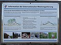 Information der Internationalen Rheinregulierung.jpg 4,080 × 3,072; 3.15 MB
-
 Informationskarte Revitalisierung Emmebach, Altach, Vorarlberg, Österreich.jpg 4,080 × 3,072; 2.68 MB
-
 Infotafel des Walserkulturwegs.JPG 720 × 960; 256 KB
-
 Infotafel Walser Kulturweg Nr. 2.JPG 720 × 960; 253 KB
-
 Infotafel Walser Kulturweg.JPG 720 × 960; 258 KB
-
 Kapelle Stofel bei der Alpe Oberdamüls 04.JPG 4,912 × 7,360; 16.86 MB
-
 Kirche Tosters St. Corneli Schild.jpg 4,320 × 3,240; 5.39 MB
-
 Klostertaler Bergwälder, Informationstafel.jpg 3,000 × 4,000; 5.91 MB
-
 Kriegerdenkmal - panoramio (26).jpg 1,931 × 2,096; 1.08 MB
-
 Laterns, Obere Bäckenwald-Alpe, Schild.jpg 4,320 × 3,240; 5.47 MB
-
 Lecknersee Geschichte.jpg 3,240 × 4,320; 4.81 MB
-
 Lindele auf Latus Schild.jpg 4,320 × 3,240; 5.51 MB
-
 Lourdeskapelle - panoramio (5).jpg 2,816 × 2,120; 1.32 MB
-
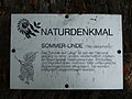
 Marienlinde Schild.jpg 4,320 × 3,240; 5.46 MB
-
 Messmerhaus Tosters St. Corneli Schild.jpg 4,320 × 3,240; 5.44 MB
-
 Natura-2000-Gebiet Ludescherberg Tafel.jpg 3,232 × 3,232; 3.54 MB
-
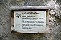 Naturdenkmal Höhlenpark am Klausenstein in Bezau.jpg 7,360 × 4,912; 12.98 MB
-
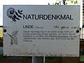
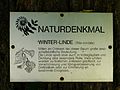
 Naturdenkmal Linde in Andelsbuch.JPG 4,912 × 7,360; 21 MB
-
 Nenzing, Eiche Gampelüner Straße, Schild.jpg 4,000 × 3,000; 4.38 MB
-
 Obere Mähder Schild 1.jpg 3,240 × 4,320; 4.68 MB
-
 Obere Mähder Schild 2.jpg 3,240 × 4,320; 4.67 MB
-
 Obere Mähder Schild 3.jpg 3,240 × 4,320; 4.63 MB
-
 Pfarrkirche St. Jodok - panoramio.jpg 2,677 × 2,113; 1.84 MB
-
 Rösslelinde Schild.jpg 4,320 × 3,240; 5.5 MB
-

-
 Sandgrube Mäder Schild.jpg 3,240 × 4,320; 5.09 MB
-
 Schild Pfarrkirche Maria Opferung Riezlern.JPG 1,616 × 2,210; 2.51 MB
-
 Schild St. Anna in Hirschegg.JPG 1,772 × 2,446; 1.5 MB
-
 Schild St. Martin in Baad.jpg 1,704 × 2,334; 2.56 MB
-
 Sommerlinde Maria Ebene Schild.jpg 4,320 × 3,240; 5.49 MB
-
 St. Antoniuskapelle (Lustenau) Tafel.jpg 3,240 × 3,720; 1.34 MB
-
 St. Michaelskapelle (Hittisau) Erklärung.jpg 3,240 × 4,320; 4.87 MB
-
 St. Wolfgangskapelle (Tosters) Schild.jpg 4,320 × 3,240; 5.37 MB
-
 Tafel Auf den Spuren Hohenemser Geschichte - Jüdisches Viertel (Hohenems).jpg 2,366 × 3,887; 2.51 MB
-
 Wolfurt, Stiel-Eiche im Holzried, Schild.jpg 4,000 × 3,000; 6.08 MB


.jpg)
_2.jpg)
_2022-06-11_Mattes.jpg)


.jpg)


.jpg)


.jpg)


.jpg)


_Tafel.jpg)
_Erkl%C3%A4rung.jpg)
_Schild.jpg)
.jpg)

,_Tafel.jpg)