Category:Ingleborough - maps
Media in category "Ingleborough - maps"
The following 6 files are in this category, out of 6 total.
-
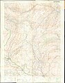
 Ordnance Survey One-Inch Sheet 90 Askrigg & Settle, Published 1947.jpg 11,023 × 12,801; 18.97 MB
-
 Ordnance Survey One-Inch Sheet 90 Wensleydale, Published 1961.jpg 8,300 × 9,865; 11.92 MB
-
 Ordnance Survey Outdoor Leisure Map of the Three Peaks, Published 1973.jpg 14,517 × 18,517; 104.56 MB
-
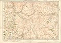 Ordnance Survey Sheet 20 Kirkby Lonsdale & Hawes, Published 1925.jpg 12,160 × 8,553; 11.61 MB
-
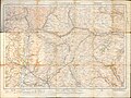 Ordnance Survey Sheet 20 Kirkby Lonsdale & Hawes, Published 1928.jpg 11,893 × 8,914; 11.35 MB
-
 Ordnance Survey Sheet SD 77 Ingleborough Hill, Published 1959.jpg 5,565 × 5,861; 3.5 MB


