Category:Interstate 90 in Minnesota
States of the United States: Idaho · Illinois · Indiana · Massachusetts · Minnesota · Montana · New York · Ohio · Pennsylvania · South Dakota · Washington · Wisconsin · Wyoming
section of Interstate Highway in Minnesota, United States  .svg) _map.svg) | |||||
| Upload media | |||||
| Instance of | |||||
|---|---|---|---|---|---|
| Location | Minnesota | ||||
| Transport network |
| ||||
| Owned by | |||||
| Maintained by | |||||
| Length |
| ||||
| Terminus | |||||
| |||||
English: Media related to Interstate 90 in Minnesota, a 275.7-mile (443.7 km) section of Interstate Highway in Minnesota, United States.
Subcategories
This category has the following 2 subcategories, out of 2 total.
Pages in category "Interstate 90 in Minnesota"
This category contains only the following page.
Media in category "Interstate 90 in Minnesota"
The following 38 files are in this category, out of 38 total.
-
 I-90 (MN).svg 601 × 601; 21 KB
-
 Albert Lea, Minnesota 2.jpg 8,476 × 2,787; 17.59 MB
-
 Alden, Minnesota 2.jpg 4,000 × 2,943; 9.65 MB
-
 America's Highways 1776–1976 - page 359.jpg 2,178 × 1,627; 2.55 MB
-
 Beaver Creek MN water tower on I90.jpg 2,592 × 1,728; 1.14 MB
-
 Blue Earth Rest Area, Blue Earth, Minnesota 01.jpg 3,024 × 4,032; 5.64 MB
-
 Blue Earth Rest Area, Blue Earth, Minnesota 02.jpg 3,024 × 4,032; 5.1 MB
-
 Blue Earth Rest Area, Blue Earth, Minnesota 03.jpg 4,032 × 3,024; 4.65 MB
-
 Blue Earth, Minnesota.jpg 4,000 × 3,000; 10.88 MB
-
 DakotaMinnesotaPanoramaI90EntranceRamp.jpg 1,936 × 1,288; 1.09 MB
-
 Des Moines Township, MN, USA - panoramio.jpg 3,536 × 2,572; 1.47 MB
-
 DresbachMinnesotaPanoramaI90.jpg 1,936 × 1,288; 1.06 MB
-
 Freewayentrancesign-minnesota.jpg 200 × 231; 67 KB
-
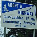 GLCSsign.jpg 640 × 640; 147 KB
-
 I-90 (MN) map.svg 1,475 × 860; 104 KB
-
 I-90 - panoramio.jpg 1,024 × 768; 466 KB
-
 I-90 east west - panoramio.jpg 1,024 × 841; 478 KB
-
 I-90 split Minnesota 01.jpg 4,000 × 3,000; 9.17 MB
-
 I-90 split Minnesota 02.jpg 4,000 × 3,000; 9.49 MB
-
 I-90 underpass - panoramio.jpg 1,024 × 768; 423 KB
-
 I90 sign in Driftless Area Far Eastern MN.jpg 2,592 × 1,728; 2.04 MB
-
 I90AustinMN2006-05-20.JPG 2,560 × 1,920; 1.14 MB
-
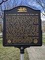
 I90GoldenSpikeRestAreaBlueEarthMN.jpg 3,603 × 2,501; 2.79 MB
-
 Interstate - 90 in Minnesota.jpg 4,000 × 3,000; 8.17 MB
-
 Interstate Highway 90 in MN.jpg 1,403 × 1,727; 217 KB
-
 Jackson County MN sign I90 looking west.jpg 2,592 × 1,728; 1.09 MB
-
 La Crosse area view over I-90.jpg 8,266 × 2,673; 14.84 MB
-
 Lock and Dam No. 7 - panoramio.jpg 3,072 × 2,304; 1.89 MB
-
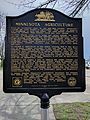
 Medical Pioneers of Minnesota - panoramio.jpg 4,000 × 3,000; 3.35 MB
-
 Minnesota Welcome Sign - panoramio (1).jpg 3,072 × 2,304; 2.48 MB
-
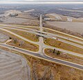
 MN-43 and I-90 junction.jpg 3,949 × 2,913; 7.17 MB
-
 MN-76 & I-90 junction.jpg 4,000 × 3,834; 9.16 MB
-
 MNAdoptHighwaySignI90.JPG 1,047 × 1,245; 1.62 MB
-
 Olney Township, MN, USA - panoramio.jpg 3,968 × 2,780; 1.57 MB
-
 On ramp to I-90 west - panoramio.jpg 1,024 × 768; 394 KB
-
 US 14-61 and I-90 junction 01.jpg 4,000 × 3,000; 8.09 MB
-
 US 14-61 and I-90 junction 02.jpg 4,000 × 3,000; 8.55 MB
-
 US 169 leads to I-90, Blue Earth, MN.jpg 2,349 × 1,760; 1.88 MB


.jpg)


