Category:Inverkip power station chimney
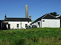
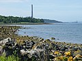
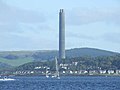
The tall chimney of Inverkip power station is widely visible and is frequently the only part of the former power station in an image- this category is for such images.
Media in category "Inverkip power station chimney"
The following 45 files are in this category, out of 45 total.
-
 A Last Sunset On The Stack - geograph.org.uk - 3579962.jpg 3,448 × 4,592; 2 MB
-
 Ardgowan Policies - geograph.org.uk - 746226.jpg 640 × 480; 93 KB
-
 Bankfoot And The Kip Valley - geograph.org.uk - 281665.jpg 640 × 316; 54 KB
-
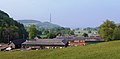
 Barn at Finnock Bog Farm - geograph.org.uk - 531943.jpg 542 × 480; 167 KB
-
 Beach Hut at Lunderston Bay - geograph.org.uk - 324503.jpg 640 × 480; 191 KB
-
 Beach Hut at Lunderston Bay - geograph.org.uk - 324507.jpg 640 × 358; 99 KB
-
 Broken fence - geograph.org.uk - 581440.jpg 480 × 640; 70 KB
-

-
 Dominated by Industry - geograph.org.uk - 1536630.jpg 640 × 313; 30 KB
-
 Electrical sub station - geograph.org.uk - 32495.jpg 640 × 480; 95 KB
-
 Farewell To A Well-Known Landmark - geograph.org.uk - 3579983.jpg 1,280 × 720; 93 KB
-
 Field at Kelly Mains - geograph.org.uk - 1101461.jpg 640 × 480; 56 KB
-
 Fields 7, 8 and 9 - geograph.org.uk - 572825.jpg 640 × 480; 75 KB
-
 Finnock Bog Farm - geograph.org.uk - 32503.jpg 640 × 480; 92 KB
-
 Finnock Bog Farm - geograph.org.uk - 531945.jpg 640 × 480; 66 KB
-

-
 Hill Farm housing estates - geograph.org.uk - 1425239.jpg 640 × 382; 46 KB
-
 Hill pasture - geograph.org.uk - 581443.jpg 640 × 480; 50 KB
-
 Inverkip Bay - geograph.org.uk - 3553674.jpg 3,448 × 4,592; 2.84 MB
-
 Inverkip marina and power station chimney - geograph.org.uk - 714284.jpg 640 × 596; 106 KB
-
 Inverkip Power Station - geograph.org.uk - 1039845.jpg 640 × 480; 25 KB
-
 Inverkip Power Station - geograph.org.uk - 1958509.jpg 640 × 480; 155 KB
-
 Inverkip Power Station - geograph.org.uk - 996396.jpg 640 × 480; 27 KB
-
 Inverkip power station chimney - geograph.org.uk - 3563209.jpg 640 × 338; 70 KB
-
 Inverkip power station chimney - geograph.org.uk - 3563211.jpg 640 × 338; 68 KB
-

-
 Inverkip War Memorial - geograph.org.uk - 734595.jpg 480 × 640; 76 KB
-
 Inverkip Yacht Club - geograph.org.uk - 289606.jpg 480 × 640; 78 KB
-
 Kip Marina - geograph.org.uk - 1087303.jpg 640 × 480; 57 KB
-
 Kip Marina - geograph.org.uk - 574176.jpg 480 × 640; 93 KB
-
 Kip Water - geograph.org.uk - 714317.jpg 640 × 537; 89 KB
-
 Langhill Farm - geograph.org.uk - 410030.jpg 640 × 480; 70 KB
-
 Looking up the Firth of Clyde - Flickr - Graham Grinner Lewis.jpg 2,048 × 1,536; 622 KB
-
 Lunderston Bay Path - geograph.org.uk - 28276.jpg 640 × 480; 85 KB
-
 Shielhill Glen - geograph.org.uk - 1159724.jpg 640 × 480; 91 KB
-
 Storm passing Inverkip - geograph.org.uk - 302337.jpg 621 × 640; 43 KB
-
 The paddle steamer Waverley - geograph.org.uk - 2532061.jpg 1,500 × 1,125; 193 KB
-
 The Perch Beacon - geograph.org.uk - 3072355.jpg 3,448 × 4,592; 2.24 MB
-
 The Perch Beacon And Inverkip Power Station Chimney - geograph.org.uk - 3579952.jpg 3,448 × 4,592; 1.79 MB
-
 Toward Point and Bute - geograph.org.uk - 1438557.jpg 640 × 480; 63 KB
-
 View across Wemyss Bay - geograph.org.uk - 1039563.jpg 640 × 248; 13 KB
-
 Wemyss Bay ferry terminal - geograph.org.uk - 799282.jpg 640 × 480; 48 KB
-
 Wemyss Bay station and pier - geograph.org.uk - 1039553.jpg 640 × 480; 38 KB
-
 Wemyss Point - geograph.org.uk - 1077964.jpg 640 × 480; 59 KB
-
 Whiting Road - geograph.org.uk - 467540.jpg 640 × 480; 40 KB


