Category:Irby farmhouse
| Object location | | View all coordinates using: OpenStreetMap |
|---|
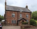
Grade II listed farmhouse in Irby, Wirral, Merseyside, UK  | |||||
| Upload media | |||||
| Instance of | |||||
|---|---|---|---|---|---|
| Location | Irby, Wirral, Merseyside, North West England, England | ||||
| Heritage designation |
| ||||
 | |||||
This is a category about listed building number 1343518. |
Grade II listed farmhouse in Irby village, Wirral. The surrounding farm buildings have been sold off and converted into dwellings and a restaurant.
Media in category "Irby farmhouse"
The following 3 files are in this category, out of 3 total.
-
 Irby farmhouse datestone 1612.jpg 5,184 × 3,456; 8.97 MB
-
 Irby farmhouse datestone 1731.jpg 3,468 × 2,532; 5.57 MB
-
 Irby farmhouse.jpg 4,389 × 3,465; 8.8 MB

