Category:Jüdischer Friedhof (Nochern)
| Object location | | View all coordinates using: OpenStreetMap |
|---|
.jpg) | |||||
| Upload media | |||||
| Instance of | |||||
|---|---|---|---|---|---|
| Location | Rhineland-Palatinate, Germany | ||||
| Heritage designation | |||||
 | |||||
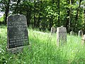
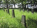
English: Jewish cemetery, Nochern, Rhineland-Palatinate, Germany
Deutsch: Jüdischer Friedhof (Nochern), Rhein-Lahn-Kreis, Rheinland-Pfalz
Media in category "Jüdischer Friedhof (Nochern)"
The following 4 files are in this category, out of 4 total.
-
 Nochern Jüdischer Friedhof (1).jpg 3,648 × 2,736; 3.88 MB
-
 Nochern Jüdischer Friedhof (2).jpg 3,648 × 2,736; 3.91 MB
-
 Nochern Jüdischer Friedhof (3).jpg 3,648 × 2,736; 4.89 MB
-
 Nochern Jüdischer Friedhof (4).jpg 2,613 × 3,482; 3.8 MB
.jpg)
.jpg)
.jpg)