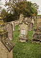
Category:Jüdischer Friedhof (Oberlauringen)
| Upload media | |||||
| Instance of | |||||
|---|---|---|---|---|---|
| Location | Bavaria, Germany | ||||
| Heritage designation | |||||
 | |||||
This is the category of the Bavarian Baudenkmal (cultural heritage monument) with the ID D-6-78-181-162 (Wikidata)
|
Media in category "Jüdischer Friedhof (Oberlauringen)"
The following 7 files are in this category, out of 7 total.
-
 Oberlauringen-3906.jpg 1,800 × 1,200; 1.84 MB
-
 Oberlauringen-3908.jpg 777 × 1,200; 932 KB
-
 Oberlauringen-3909.jpg 1,800 × 1,200; 1.39 MB
-
 Oberlauringen-3911.jpg 794 × 1,200; 940 KB
-
 Oberlauringen-3913.jpg 849 × 1,200; 1.2 MB
-
 Oberlauringen-3916.jpg 3,264 × 4,896; 6.34 MB
-
 Oberlauringen-3980.jpg 1,800 × 1,200; 1.71 MB


