Category:Jacques Pervititch's maps of Istanbul-Şişli
Media in category "Jacques Pervititch's maps of Istanbul-Şişli"
The following 16 files are in this category, out of 16 total.
-
 Pervititch-Maps of Istanbul-Feriköy, Ayazma-9.jpg 2,080 × 2,453; 2.24 MB
-
 Pervititch-Maps of Istanbul-Feriköy, Nişantaşı-6.jpg 2,466 × 2,132; 2.3 MB
-
 Pervititch-Maps of Istanbul-Feriköy-8.jpg 2,127 × 2,441; 2.12 MB
-
 Pervititch-Maps of Istanbul-Nişantaşı-4.jpg 2,447 × 2,112; 2.2 MB
-
 Pervititch-Maps of Istanbul-Nişantaşı-5.jpg 2,417 × 2,109; 1.93 MB
-
 Pervititch-Maps of Istanbul-Pangaltı, Dolapdere, Sinemköy-11.jpg 2,442 × 2,068; 2.3 MB
-
 Pervititch-Maps of Istanbul-Pangaltı-7.jpg 2,467 × 2,142; 2.32 MB
-
 Pervititch-Maps of Istanbul-Tatavla, Tepe-10.jpg 2,033 × 2,431; 2.13 MB
-
 Pervititch-Maps of Istanbul-Tatavla-14.jpg 2,074 × 2,447; 2.4 MB
-
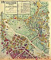
 Pervititch-Maps of Istanbul-Yenişehir, Tatavla-13.jpg 2,118 × 2,431; 2.36 MB
-

-
 Pervititch-Maps of Istanbul-Yenişehir, Tatavla-15.jpg 2,072 × 2,431; 2.17 MB
-
 Pervititch-Maps of Istanbul-Şişli-1 (Şişli Mosque, cropped).jpg 233 × 380; 62 KB
-
 Pervititch-Maps of Istanbul-Şişli-1.jpg 2,441 × 2,180; 1.96 MB
-
 Pervititch-Maps of Istanbul-Şişli-2.jpg 2,458 × 2,174; 1.84 MB
-
 Pervititch-Maps of Istanbul-Şişli-3.jpg 2,127 × 2,462; 2.16 MB


.jpg)

.jpg)


