Category:Johkegaske (original location)
| Object location | | View all coordinates using: OpenStreetMap |
|---|
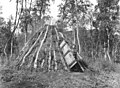
Johkegaske was a permanent summer camp used by Sami people in the Rørvik area. It was located at the outlet of the small river Buvriejohke into lake Namsvatnet/Nåamesjenjaevrie. When Nåamesjenjaevrie was dammed in 1959, the place was drowned. A new camp with the name Johkegaske was created further to the north, on the new shoreline. The location of the old camp is approximately given from a map shown in the book Røyrvik: Samene i Østre Namdal by Håkon Hermanstrand (2009), p. 360.
Media in category "Johkegaske (original location)"
The following 6 files are in this category, out of 6 total.
-
 Anna Dærgas sommergamme ved Namsvatnet, 1956 - Norsk folkemuseum - NF.05535-086.jpg 1,746 × 1,311; 583 KB
-

-
-

-

-
 Oskar Jåmas sommergamme, Namsvatnet, 1956 - Norsk folkemuseum - NF.05535-076.jpg 1,756 × 1,271; 548 KB


