Category:July 2009 in Cumbria
Deutsch: Bilder, die im Juli 2009 in Cumbria aufgenommen worden sind. Bitte beachten Sie, dass dies weder das Datum des Uploads noch das Datum des Scannens eines Fotos ist.
English: Images/pictures taken in Cumbria during July 2009. Note this is not the date of the upload, nor the date a photo was scanned.
Español: Fotografías o imágenes tomadas en Cumbria durante julio 2009. No es la fecha de subida ni escaneo, sino la fecha en que las fotografías o imágenes se crearon.
Esperanto: Bildoj faritaj en Cumbria en julio 2009. Tio ne estas la dato, kiam la bildoj estis alŝutitaj aŭ skanitaj.
Français : Photographies ou images prises en Cumbria durant juillet 2009. Ce n'est pas la date du téléchargement ou du scan.
Galego: Fotografías ou imaxes tomadas en Cumbria durante xullo 2009. Non é a data de subida nin escaneamento, senón a data na que se crearon as fotografías ou imaxes.
Italiano: Fotografie o immagini scattate a Cumbria nel luglio 2009. Nota bene: la data non si riferisce né a quella di upload né a quella in cui la foto è stata digitalizzata.
Norsk bokmål: Bilder tatt i Cumbria i løpet av juli 2009. Merk at dette ikke er datoen for opplasting, eller når et bilde har blitt skannet.
Norsk nynorsk: Bilete teke i Cumbria i løpet av juli 2009. Merk at dette ikkje er datoen for opplasting, eller når eit bilete har vorte skanna.
Русский: Изображения, сделанные в Cumbria в течение июль 2009 (не дата загрузки изображения).
Українська: Зображення, зроблені в Cumbria протягом липень 2009. Зауважте, що це не дата завантаження чи дата сканування фотографії.
| July 2008 | ← | July 2009 | → | July 2010 | |||||||
| Jan | Feb | Mar | Apr | May | Jun | Jul | Aug | Sep | Oct | Nov | Dec |
| 26 | 44 | 43 | 63 | 76 | 28 | 33 | 52 | 70 | 109 | 40 | 19 |
|---|---|---|---|---|---|---|---|---|---|---|---|
Media in category "July 2009 in Cumbria"
The following 33 files are in this category, out of 33 total.
-
 Street in Boot - geograph.org.uk - 1386917.jpg 480 × 640; 70 KB
-
 Beside Rydal Water - geograph.org.uk - 1392769.jpg 640 × 480; 53 KB
-
 Cavendish Park Barrow Island - geograph.org.uk - 1406136.jpg 640 × 457; 438 KB
-
 Dunvegan Street Barrow Island - geograph.org.uk - 1406117.jpg 640 × 457; 315 KB
-
 Dunvegan Street Barrow Island - geograph.org.uk - 1406149.jpg 640 × 457; 272 KB
-
 Dunvegan Street Barrow Island - geograph.org.uk - 1406185.jpg 640 × 457; 348 KB
-
 Island Road Barrow Island - geograph.org.uk - 1406132.jpg 640 × 457; 273 KB
-
 Island Road Barrow Island - geograph.org.uk - 1406182.jpg 640 × 457; 253 KB
-
 Rothesay Street Barrow Island - geograph.org.uk - 1406142.jpg 640 × 457; 280 KB
-

-
 A 5084 - geograph.org.uk - 1406027.jpg 640 × 480; 98 KB
-
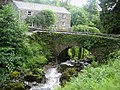 Bridge over Rydal Beck - geograph.org.uk - 1392639.jpg 640 × 480; 141 KB
-
 Brim Fell Ridge - geograph.org.uk - 1404334.jpg 640 × 480; 56 KB
-
 By-road above Bayles - geograph.org.uk - 1418496.jpg 640 × 480; 75 KB
-
 Carlisle at 7am^ - geograph.org.uk - 1519482.jpg 480 × 640; 104 KB
-
 Class 502 EMU at Tebay.jpg 1,024 × 768; 191 KB
-
 Cows in rough pasture near Caldbeck - geograph.org.uk - 1567587.jpg 640 × 480; 146 KB
-
 Emlyn Hughes Barrow.jpg 640 × 447; 66 KB
-
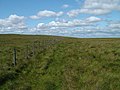 Fence on Black Moss - geograph.org.uk - 1418641.jpg 640 × 480; 79 KB
-
 Fence on Robinson - geograph.org.uk - 1409789.jpg 640 × 480; 80 KB
-
 Footpath leaving High Hay Wood - geograph.org.uk - 1399536.jpg 640 × 480; 71 KB
-
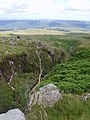
 From Rannerdale Knotts - geograph.org.uk - 776314.jpg 640 × 480; 75 KB
-
 How Beck waterfall - geograph.org.uk - 1419182.jpg 640 × 480; 98 KB
-
 Lawsonpark2009.jpg 640 × 427; 520 KB
-
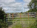 Modern sheepfold opposite Ty'n Rhos - geograph.org.uk - 1400097.jpg 640 × 480; 103 KB
-
 Red Gill Beck - geograph.org.uk - 1405931.jpg 640 × 480; 74 KB
-
 Red Gill Beck - geograph.org.uk - 1405936.jpg 640 × 480; 126 KB
-
 Red Gill Beck - geograph.org.uk - 1405939.jpg 480 × 640; 104 KB
-
 Red Gill Beck - geograph.org.uk - 1405942.jpg 480 × 640; 94 KB
-
 Steamer On Ullswater (3718419858).jpg 3,264 × 2,448; 1.48 MB
-
 The Green railway station (3721736672).jpg 1,600 × 1,085; 555 KB
-

-
 Wesleyan Methodist Chapel - geograph.org.uk - 1396189.jpg 640 × 480; 64 KB


.jpg)
.jpg)

