Category:June 1973 in Montana
English: Images/pictures taken in Montana during June 1973. Note this is not the date of the upload, nor the date a photo was scanned.
States of the United States: Arizona · California · Florida · Georgia · Illinois · Louisiana · Maryland · Massachusetts · Michigan · Minnesota · Montana · Nevada · New Jersey · New York · Ohio · Oregon · Pennsylvania · Rhode Island · Washington · Wyoming – Washington, D.C.
| June 1972 | ← | June 1973 | → | June 1974 | |||||||||
| Jan | Feb | Mar | Apr | May | Jun | Jul | Aug | Sep | Oct | Nov | Dec | ||
| ← | 0 | 1 | 0 | 0 | 0 | 114 | 3 | 0 | 0 | 0 | 0 | 0 | → |
|---|---|---|---|---|---|---|---|---|---|---|---|---|---|
Media in category "June 1973 in Montana"
The following 114 files are in this category, out of 114 total.
-
 350 MEGAWATT POWER PLANT UNDER CONSTRUCTION AT COLSTRIP - NARA - 549127.jpg 3,000 × 2,037; 1.1 MB
-
 350 MEGAWATT POWER PLANT UNDER CONSTRUCTION AT COLSTRIP - NARA - 549128.jpg 2,031 × 3,000; 941 KB
-

-

-

-

-
-
 ACME COAL MINE - NARA - 549240.jpg 2,026 × 3,000; 904 KB
-
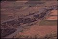
 ALFALFA FIELD NEAR THE TONGUE RIVER - NARA - 549250.jpg 1,988 × 3,000; 1.28 MB
-
 ALFALFA FIELD ON THE JOHN REDDING RANCH IN SARPY BASIN - NARA - 549233.jpg 2,042 × 3,000; 776 KB
-

-

-

-

-

-

-

-

-
-
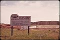
 DECKER'S POST OFFICE AND GENERAL STORE - NARA - 549196.jpg 3,000 × 2,035; 837 KB
-
 DRAGONFLY ON MARSH GRASS NEAR SARPY BASIN - NARA - 549144.jpg 3,000 × 2,026; 554 KB
-
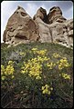
 FLOWERS AMID THE PRAIRIE GRASSES ON THE CROW INDIAN RESERVATION - NARA - 549229.jpg 2,003 × 3,000; 1,009 KB
-
 FLOWERS AMID THE PRAIRIE GRASSES ON THE CROW INDIAN RESERVATION - NARA - 549230.jpg 3,000 × 2,043; 896 KB
-
 FLOWERS AND ROCK FORMATIONS AT THE ROY FLY RANCH IN SARPY BASIN - NARA - 549228.jpg 2,030 × 3,000; 1,001 KB
-

-
 Frog in marshy stream near Sarpy Basin, 06-1973. (7065782069).jpg 3,000 × 2,036; 453 KB
-

-
 Harvest06 (37972598755).jpg 2,250 × 1,500; 5.14 MB
-

-
 HAY FIELD AT THE JOHN REDDING RANCH IN SARPY BASIN - NARA - 549237.jpg 3,000 × 1,983; 758 KB
-

-
-

-

-

-

-

-

-

-

-

-
-

-

-
-

-
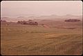
 OPEN RANGE LAND NEAR CUSTER BATTLE FIELD NATIONAL MONUMENT - NARA - 549158.jpg 3,000 × 2,032; 1.04 MB
-
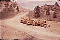
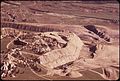
 PEABODY COAL COMPANY STRIP MINE, SOUTH OF COLSTRIP - NARA - 549124.jpg 3,000 × 2,031; 833 KB
-
 PEABODY COAL COMPANY STRIP MINE, SOUTH OF COLSTRIP - NARA - 549125.jpg 3,000 × 2,033; 827 KB
-
 PEABODY COAL COMPANY STRIP MINE, SOUTH OF COLSTRIP - NARA - 549126.jpg 3,000 × 2,044; 714 KB
-
 PEABODY COAL COMPANY STRIP MINE, SOUTH OF COLSTRIP - NARA - 549167.jpg 2,017 × 3,000; 1.27 MB
-
 PEABODY COAL COMPANY STRIP MINE, SOUTH OF COLSTRIP - NARA - 549168.jpg 3,000 × 2,033; 941 KB
-
 PEABODY COAL COMPANY STRIP MINE, SOUTH OF COLSTRIP - NARA - 549177.jpg 2,033 × 3,000; 933 KB
-

-
-

-
 Ranch in the Powder River Basin, 06-1973 (6919829198).jpg 3,000 × 2,029; 185 KB
-

-

-
 Ranch lands and prairie near Little Bighorn Battlefield National Monument 06-73.jpg 2,973 × 1,982; 3.67 MB
-

-
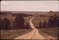 RANCH ROAD NEAR COLSTRIP - NARA - 549235.jpg 3,000 × 2,050; 734 KB
-
 Ranch road near Colstrip, 06-1973 (7065935925).jpg 3,000 × 2,050; 348 KB
-

-

-

-

-
 ROAD LEADS TO THE BUD AND JOHN REDDING RANCHES IN SARPY BASIN - NARA - 549257.jpg 3,000 × 2,015; 586 KB
-
 Road leads to the Bud and John Redding Ranches in Sarpy Basin, 06-1973 (7065943971).jpg 3,000 × 2,015; 246 KB
-

-

-

-

-

-

-

-

-

-
 Susan Marie Jaeger New York Daily News 13 July 1975.jpg 238 × 283; 33 KB
-
-

-
 The Bud Redding ranch at sunset, 06-1973 (6919853746).jpg 3,000 × 2,046; 241 KB
-

-
 The Bud Redding ranch in Sarpy Basin, 06-1973 (6919825084).jpg 3,000 × 2,020; 254 KB
-
 The Bud Redding ranch in Sarpy Basin, 06-1973 (7065912103).jpg 3,000 × 2,038; 491 KB
-

-

-

-

-
 THE ROY FLY RANCH IN SARPY BASIN - NARA - 549225.jpg 2,023 × 3,000; 879 KB
-
 The Roy Fly ranch in Sarpy Basin, 06-1973 (6919823166).jpg 2,023 × 3,000; 438 KB
-

-

-
 These strip-mining spoil piles are about 20 years old, 06-1973 (6919748144).jpg 3,000 × 2,054; 410 KB
-

-
-

-

-

-

-

-
 Toy car on the John Redding Ranch at Sarpy Basin..., 06-1973 (6919740398).jpg 3,000 × 2,041; 480 KB
-

-

-
 UNTOUCHED PRAIRIE GRASSES NEAR COLSTRIP - NARA - 549227.jpg 3,000 × 2,022; 1.34 MB
-
 Untouched prairie grasses near Colstrip, 06-1973 (6919826640).jpg 3,000 × 2,022; 725 KB
-
 VIRGIN PRAIRIE GRASS NEAR COLSTRIP - NARA - 549232.jpg 2,027 × 3,000; 1.1 MB
-
 Virgin prairie grass near Colstrip, 06-1973 (6919837530).jpg 2,027 × 3,000; 615 KB
-
 WESTERN ENERGY STRIP MINE AND SPOIL PILES, SOUTH OF COLSTRIP - NARA - 549170.jpg 3,000 × 2,033; 1.13 MB
-
 Western Energy strip mine and spoil piles, south of Colstrip, 06-1973. (7065793643).jpg 3,000 × 2,033; 622 KB
-

-

-

-


.jpg)

.jpg)


.jpg)
.jpg)
.jpg)
.jpg)

.jpg)


.jpg)
.jpg)

.jpg)

.jpg)

.jpg)
.jpg)
.jpg)
.jpg)
.jpg)

.jpg)
.jpg)

.jpg)
.jpg)
.jpg)
.jpg)

.jpg)
.jpg)

.jpg)
.jpg)
.jpg)
.jpg)
.jpg)
.jpg)
.jpg)
.jpg)
.jpg)
.jpg)

.jpg)

.jpg)
.jpg)
.jpg)
.jpg)
.jpg)
.jpg)
.jpg)
.jpg)

.jpg)
.jpg)


.jpg)

.jpg)

.jpg)

.jpg)

.jpg)
.jpg)