Category:June 2008 in Utah
English: Images/pictures taken in Utah during June 2008. Note this is not the date of the upload, nor the date a photo was scanned.
States of the United States: Alabama · Alaska · Arizona · Arkansas · California · Colorado · Delaware · Florida · Georgia · Hawaii · Idaho · Illinois · Indiana · Iowa · Kansas · Kentucky · Louisiana · Maine · Maryland · Massachusetts · Michigan · Minnesota · Mississippi · Missouri · Montana · Nebraska · Nevada · New Hampshire · New Jersey · New Mexico · New York · North Carolina · North Dakota · Ohio · Oklahoma · Oregon · Pennsylvania · Rhode Island · South Dakota · Tennessee · Texas · Utah · Vermont · Virginia · Washington · West Virginia · Wisconsin · Wyoming – Washington, D.C.
Puerto Rico
Puerto Rico
| June 2007 | ← | June 2008 | → | June 2009 | |||||||||
| Jan | Feb | Mar | Apr | May | Jun | Jul | Aug | Sep | Oct | Nov | Dec | ||
| ← | 32 | 46 | 123 | 41 | 85 | 41 | 52 | 163 | 81 | 47 | 81 | 24 | → |
|---|---|---|---|---|---|---|---|---|---|---|---|---|---|
Media in category "June 2008 in Utah"
The following 41 files are in this category, out of 41 total.
-
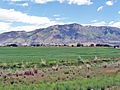 08-64-City of Elwood,UT,with,Mendon Peak in background as seen from I-15. June 8,2008.jpg 2,816 × 2,112; 4.35 MB
-
 2008.06.18 14.32.55 CIMG0047 - Flickr - andrey zharkikh.jpg 3,648 × 2,736; 3.21 MB
-
 2008.06.18 14.36.53 CIMG0048 - Flickr - andrey zharkikh.jpg 3,648 × 2,736; 2.45 MB
-
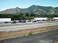 80slctraffic.jpg 3,296 × 2,472; 1.17 MB
-
 Abandoned Gas Station - panoramio (1).jpg 2,400 × 3,000; 1.4 MB
-
 ArchesNationalParkDelicateArch.jpg 3,456 × 2,304; 3.05 MB
-
 Arctic Circle Restaurant.jpeg 2,560 × 1,920; 1.03 MB
-
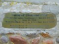 Battle of Diamond Fork monument plaque, Mar 17.jpg 2,592 × 1,944; 2.16 MB
-
 Broken Statue Daniel's Dream Gilgal Garden 2.JPG 3,264 × 2,448; 1.52 MB
-
 Canyonlands from Ancestral Puebloan Granary at the Top of Aztec Butte.jpg 2,816 × 1,880; 1.97 MB
-
 Clearfield Utah City Center.jpg 2,560 × 1,920; 1.09 MB
-
 Cohab Canyon River Valley Overlook.jpg 2,816 × 1,880; 2.81 MB
-
 Danger Keep Off Sign at Cohab Canyon Trail.jpg 2,816 × 1,880; 2.44 MB
-
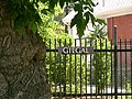 Entrance gilgal.JPG 3,264 × 2,448; 1.54 MB
-
 Folded Rock Layers at Taylor Creek Trail - Zion National Park.jpg 1,280 × 960; 878 KB
-
 Gilgal 4.JPG 3,264 × 2,448; 1.55 MB
-
 Gilgal garden 1.JPG 2,328 × 1,632; 603 KB
-
 Hill, Utah.JPG 3,132 × 2,083; 1.06 MB
-
 I-80 East Salt Flats.JPG 1,600 × 895; 171 KB
-
 Keyhole Canyon dyeclan.com - panoramio (2).jpg 2,748 × 3,664; 1.88 MB
-
 Mayor Becker (2561592867).jpg 900 × 600; 125 KB
-
 Mayor Becker (2571517063).jpg 1,086 × 724; 223 KB
-
 Mt. Moroni, Zion National Park.jpg 1,944 × 2,592; 711 KB
-
 David-McKay-events-center-logo.jpg 1,490 × 474; 235 KB
-
 Picea pungens Bryce Canyon NP 1.jpg 2,592 × 3,888; 10.4 MB
-
 Picea pungens Bryce Canyon NP 2.jpg 1,320 × 1,971; 2.37 MB
-
 Picea pungens Bryce Canyon NP 3.jpg 3,888 × 2,592; 10.77 MB
-
 Planetarium TRAX station, June 2008.jpg 3,200 × 2,400; 1.67 MB
-
 Rainbow bridge 231MP.jpg 25,816 × 8,935; 24.36 MB
-
 Shafer trail 1 Canyonlands.jpg 3,945 × 1,600; 4.13 MB
-
 Singleleaf Ash Fraxinus anomala, Zion Canyon, Utah.jpg 3,648 × 2,736; 6.86 MB
-
 St. george utah pic.JPG 3,264 × 2,448; 1.56 MB
-
 State Street and Main Street, Hurricane, Utah.jpg 922 × 659; 480 KB
-
 Stone grasshopper Gilgal garden 3.JPG 3,264 × 2,448; 1.58 MB
-
 Tadpole at Capitol Reef Waterpocket.jpg 2,816 × 1,880; 2.48 MB
-
 UCRY 3104.jpg 2,304 × 1,536; 711 KB
-
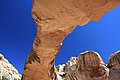 Underneath Hickman Bridge.jpg 2,816 × 1,880; 1.72 MB
-
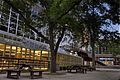 University Union building.jpg 4,318 × 2,865; 3.54 MB
-
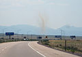 Utah Dust Devil.jpg 1,200 × 840; 263 KB
-
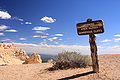 Warning - Area Closed - Dangerous Cliffs.jpg 2,816 × 1,880; 2.38 MB
-
 Zion National Park, Bee Hive Peak.jpg 3,692 × 2,580; 1.84 MB


.jpg)


.jpg)
.jpg)
.jpg)


