Category:June 2014 in Montana
English: Images/pictures taken in Montana during June 2014. Note this is not the date of the upload, nor the date a photo was scanned.
States of the United States: Alabama · Alaska · Arizona · Arkansas · California · Colorado · Connecticut · Delaware · Florida · Georgia · Hawaii · Idaho · Illinois · Indiana · Iowa · Kansas · Kentucky · Louisiana · Maine · Maryland · Massachusetts · Michigan · Minnesota · Mississippi · Missouri · Montana · Nebraska · Nevada · New Hampshire · New Jersey · New Mexico · New York · North Carolina · North Dakota · Ohio · Oklahoma · Oregon · Pennsylvania · Rhode Island · South Carolina · South Dakota · Tennessee · Texas · Utah · Vermont · Virginia · Washington · Wisconsin · Wyoming – Washington, D.C.
Puerto Rico
Puerto Rico
| June 2013 | ← | June 2014 | → | June 2015 | |||||||||
| Jan | Feb | Mar | Apr | May | Jun | Jul | Aug | Sep | Oct | Nov | Dec | ||
| ← | 5 | 0 | 1 | 46 | 101 | 80 | 1 | 1 | 17 | 2 | 1 | 0 | → |
|---|---|---|---|---|---|---|---|---|---|---|---|---|---|
Subcategories
This category has only the following subcategory.
Media in category "June 2014 in Montana"
The following 79 files are in this category, out of 79 total.
-
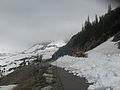
 Beginning of storm on Going-to-the-Sun Road, 6-17-2014 (14430294196).jpg 4,288 × 2,848; 3.72 MB
-
 Beginning of storm on Going-to-the-Sun Road, 6-17-2014 (14473571843).jpg 4,288 × 2,848; 4.78 MB
-
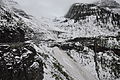
 Big Drift, 6-13-2014 (14266936287).jpg 4,288 × 2,848; 4.42 MB
-
 Big Drift, 6-13-2014 (14453381065).jpg 4,288 × 2,848; 3.95 MB
-
 Big Drift, 6-13-2014 (14453382035).jpg 4,288 × 2,848; 3.54 MB
-
 Coyote on Going-to-the-Sun Road (14196280127).jpg 3,264 × 2,448; 1.91 MB
-
 Divide Creek Flooding, 6-18-2014 (14267228570).jpg 640 × 480; 136 KB
-
 Going-to-the-Sun Road, 6-18-2014 (14458000171).jpg 2,848 × 4,288; 5.92 MB
-
 Going-to-the-Sun Road, 6-18-2014 (14460230684) (2).jpg 4,288 × 2,848; 5.29 MB
-
 Going-to-the-Sun Road, 6-18-2014 (14461345965).jpg 4,288 × 2,848; 5.96 MB
-
 Going-to-the-Sun Road, 6-18-2014 (14481509773).jpg 4,288 × 2,848; 4.12 MB
-
 Heavens Peak, 6-4-2014 (14328903906).jpg 4,288 × 2,848; 3.5 MB
-
 Hinsdale Public Schools.jpg 4,608 × 3,456; 6.43 MB
-
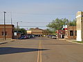 Hinsdale, Montana. Montana Street looking north.jpg 4,608 × 3,456; 6.46 MB
-
 Logan Pass parking lot, 6-12-2014 (14226134178).jpg 2,848 × 4,288; 5.25 MB
-
 Logan Pass parking lot, 6-12-2014 (14432910743).jpg 4,288 × 2,848; 5.61 MB
-
 Logan Pass, 6-11-2014 (14219522059).jpg 4,288 × 2,848; 3 MB
-
 Logan Pass, 6-11-2014 (14219522309).jpg 4,288 × 2,848; 1.89 MB
-
 Logan Pass, 6-11-2014 (14219567600).jpg 4,288 × 2,848; 3.54 MB
-
 Logan Pass, 6-11-2014 (14219727717).jpg 4,288 × 2,848; 2.73 MB
-
 Logan Pass, 6-11-2014 (14383035616).jpg 4,288 × 2,848; 2 MB
-
 Logan Pass, 6-11-2014 (14402809871).jpg 4,288 × 2,848; 2.84 MB
-
 Logan Pass, 6-11-2014 (14404845982).jpg 4,288 × 2,848; 3.56 MB
-
 Logan Pass, 6-11-2014 (14405050014).jpg 4,288 × 2,848; 3.48 MB
-
 Logan Pass, 6-17-2014 (14430294786).jpg 4,288 × 2,848; 3.89 MB
-
 Many Glacier, 6-18-2014 (14272587518).jpg 4,608 × 3,456; 3.51 MB
-
 Many Glacier, 6-18-2014 (14436079556).jpg 4,608 × 3,456; 4.1 MB
-
 Many Glacier, 6-18-2014 (14458066244).jpg 4,608 × 3,456; 4.02 MB
-
 Milwaukee Road substation, Loweth, Montana (15442012799).jpg 5,209 × 3,473; 2.39 MB
-
 Milwaukee Road substation, Loweth, Montana (15442655887).jpg 5,557 × 3,705; 2.63 MB
-
 Milwaukee Road substation, Primrose, Montana (15442530458).jpg 4,626 × 3,084; 1.74 MB
-
 Near Big Drift, 6-12-2014 (14226132048).jpg 4,288 × 2,848; 4.91 MB
-
 Near Big Drift, 6-12-2014 (14226132808).jpg 2,848 × 4,288; 5.92 MB
-
 Near Big Drift, 6-12-2014 (14411591034).jpg 4,288 × 2,848; 5.21 MB
-
 Near Big Drift, 6-12-2014 (14432909443).jpg 4,288 × 2,848; 5.69 MB
-
 Near Big Drift, 6-12-2014 (14432912143).jpg 4,288 × 2,848; 5.23 MB
-
 Near Haystack Creek, 6-19-2014 (14274806438).jpg 4,288 × 2,848; 4.67 MB
-
 Near Haystack Creek, 6-19-2014 (14274947947).jpg 4,288 × 2,848; 4.87 MB
-
 Near Haystack Creek, 6-19-2014 (14274948697).jpg 4,288 × 2,848; 6.56 MB
-
 Near Haystack Creek, 6-19-2014 (14438293726) (2).jpg 4,288 × 2,848; 6.47 MB
-
 Near Haystack Creek, 6-19-2014 (14458046021).jpg 4,288 × 2,848; 5.07 MB
-
 Near Haystack Creek, 6-19-2014 (14458048821).jpg 4,288 × 2,848; 5.29 MB
-
 Near Haystack Creek, 6-19-2014 (14460282944).jpg 4,288 × 2,848; 4.3 MB
-
 Near Haystack Creek, 6-19-2014 (14460283504).jpg 4,288 × 2,848; 4.84 MB
-
 Near No Stump Point, 6-6-2014 (14196152240).jpg 3,264 × 2,448; 1.43 MB
-
 Near No Stump Point, 6-6-2014 (14196153240).jpg 3,264 × 2,448; 1.61 MB
-
 Near No Stump Point, 6-6-2014 (14359624676).jpg 3,264 × 2,448; 1.5 MB
-
 Near No Stump Point, 6-6-2014 (14359625066).jpg 3,264 × 2,448; 1.74 MB
-
 Near No Stump Point, 6-6-2014 (14381286942).jpg 3,264 × 2,448; 1.84 MB
-
 Near No Stump Point, 6-6-2014 (14381287302).jpg 3,264 × 2,448; 1.91 MB
-
 Near No Stump Point, 6-6-2014 (14381287542).jpg 3,264 × 2,448; 1.8 MB
-
 Near No Stump Point, 6-6-2014 (14381289542).jpg 3,264 × 2,448; 1.73 MB
-
 Near No Stump Point, 6-6-2014 (14381737154).jpg 3,264 × 2,448; 2.37 MB
-
 Near No Stump Point, 6-6-2014 (14382707745).jpg 3,264 × 2,448; 1.45 MB
-
 Near No Stump Point, 6-6-2014 (14402884343).jpg 3,264 × 2,448; 1.93 MB
-
 Near No Stump Point, 6-6-2014 (14402885203).jpg 3,264 × 2,448; 2.3 MB
-
 Near Oberlin Bend, 6-10-2014 (14211804849).jpg 4,288 × 2,848; 4.76 MB
-
 Near Oberlin Bend, 6-10-2014 (14211843148).jpg 4,288 × 2,848; 3.97 MB
-
 Near Oberlin Bend, 6-10-2014 (14212015527).jpg 4,288 × 2,848; 4.08 MB
-
 Near Oberlin Bend, 6-10-2014 (14397099482).jpg 4,288 × 2,848; 5.04 MB
-
 Near Oberlin Bend, 6-10-2014 (14397369434).jpg 4,288 × 2,848; 4.41 MB
-
 Near Oberlin Bend, 6-10-2014 (14398467145).jpg 4,288 × 2,848; 4.66 MB
-
 Near Oberlin Bend, 6-10-2014 (14418619593).jpg 4,288 × 2,848; 4.6 MB
-
 Near Sperry Chalet, 6-18-2014 (14430706716) (2).jpg 960 × 720; 310 KB
-
 Post Office Sign for Hinsdale, Montana.jpg 4,608 × 3,456; 6.26 MB
-
 Rim Rock, 6-4-2014 (14165433780).jpg 4,288 × 2,848; 2.67 MB
-
 Rim Rock, 6-4-2014 (14165538107).jpg 4,288 × 2,848; 3.44 MB
-
 Rim Rock, 6-4-2014 (14372201333).jpg 4,288 × 2,848; 3.84 MB
-
 Rim Rock, 6-4-2014 (14372203293).jpg 4,288 × 2,848; 1.57 MB
-
 Road plowing equipment, 6-17-2014 (14452040632).jpg 4,288 × 2,848; 4.63 MB
-
 Rock slide above The Loop, 6-18-2014 (14274714469).jpg 4,288 × 2,848; 6.01 MB
-
 Rock slide above The Loop, 6-18-2014 (14274740410).jpg 4,288 × 2,848; 6.37 MB
-
 Sperry Chalet, 6-18-2014 (14452456722).jpg 960 × 720; 247 KB
-
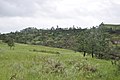
 St. Xavier, Montana (2014).jpg 4,691 × 3,127; 7.9 MB
-
 Swiftcurrent Pass Trail, Wilbur Creek flooding, 6-18-2014 (14272739627).jpg 4,608 × 3,456; 6.17 MB
-
 Tornado on Sioux Ranger District (14273514748).jpg 2,144 × 1,424; 800 KB
-
 Tornado on Sioux Ranger District (14273514898).jpg 2,144 × 1,424; 792 KB
-
 Tornado on Sioux Ranger District (14273665077).jpg 2,048 × 1,536; 540 KB
-
 Tornado on Sioux Ranger District (14437008566).jpg 2,592 × 1,944; 2.28 MB
.jpg)
.jpg)
.jpg)
.jpg)
.jpg)
.jpg)
.jpg)
.jpg)
_(2).jpg)
.jpg)
.jpg)
.jpg)


.jpg)
.jpg)
.jpg)
.jpg)
.jpg)
.jpg)
.jpg)
.jpg)
.jpg)
.jpg)
.jpg)
.jpg)
.jpg)
.jpg)
.jpg)
.jpg)
.jpg)
.jpg)
.jpg)
.jpg)
.jpg)
.jpg)
.jpg)
.jpg)
.jpg)
_(2).jpg)
.jpg)
.jpg)
.jpg)
.jpg)
.jpg)
.jpg)
.jpg)
.jpg)
.jpg)
.jpg)
.jpg)
.jpg)
.jpg)
.jpg)
.jpg)
.jpg)
.jpg)
.jpg)
.jpg)
.jpg)
.jpg)
.jpg)
.jpg)
_(2).jpg)

.jpg)
.jpg)
.jpg)
.jpg)
.jpg)
.jpg)
.jpg)
.jpg)
.jpg)
.jpg)
.jpg)
.jpg)
.jpg)
.jpg)