Category:Jutfaseweg 7, Utrecht
| Object location | | View all coordinates using: OpenStreetMap |
|---|
 | |||||
| Upload media | |||||
| Instance of | |||||
|---|---|---|---|---|---|
| Location | Utrecht, Netherlands | ||||
| Street address |
| ||||
| Heritage designation |
| ||||
 | |||||
|
This is a category about rijksmonument number 514461
|
| Address |
|
Media in category "Jutfaseweg 7, Utrecht"
The following 10 files are in this category, out of 10 total.
-
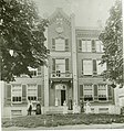 Amaliahuis begin 1900.jpg 3,639 × 3,881; 1.15 MB
-
 Amaliahuis bijgebouw.JPG 4,320 × 3,240; 3.05 MB
-
 Amaliahuis van voren.JPG 4,320 × 3,240; 2.97 MB
-
 RM 514461 - Jutfaseweg 7 - Utrecht - 1.JPG 4,928 × 3,264; 3.3 MB
-
 RM 514461 - Jutfaseweg 7 - Utrecht - 2.JPG 3,264 × 4,928; 3.2 MB
-
 RM 514461 - Jutfaseweg 7 - Utrecht - 3.JPG 4,928 × 3,264; 2.41 MB
-
 RM 514461 - Jutfaseweg 7 - Utrecht - 4.JPG 4,928 × 3,264; 4.33 MB
-
 RM 514461 - Jutfaseweg 7 - Utrecht - 5.JPG 4,928 × 3,264; 4.53 MB
-
 RM 514461 - Jutfaseweg 7 - Utrecht - 6.JPG 4,928 × 3,264; 3.71 MB
-
 RM 514461 - Jutfaseweg 7 - Utrecht - 7.JPG 3,264 × 4,928; 3.74 MB


