Category:Königlich-Sächsische Triangulirung Station 140 Schönheide
| Object location | | View all coordinates using: OpenStreetMap |
|---|
Triangulation Column, 2nd Order Station, the Royal Saxon Triangulation in Saxony 1862-1890 _(19).jpg) | |||||
| Upload media | |||||
| Instance of |
| ||||
|---|---|---|---|---|---|
| Part of | |||||
| Location | Stützengrün, Erzgebirgskreis, Saxony, Germany | ||||
| Street address |
| ||||
| Heritage designation | |||||
| Inception |
| ||||
 | |||||
This is the category for an architectural monument.
It is on the list of cultural monuments of Stützengrün.
It is on the list of cultural monuments of Stützengrün.
Auf dem bei Schönheide im Erzgebirge liegenden Kuhberg (795 Meter) wurde im Jahr 1876 eine gut mannshohe Vermessungssäule aus Granit als Station 140 (Schönheide) aufgestellt. Sie war eine von 122 Säulen der zweiten Ordnung im Rahmen des Aufbaus eines Netzes für die Landesvermessung Sachsens (Königlich-Sächsische Triangulierung). Sie steht 2017 noch an ihrem Platz.
Media in category "Königlich-Sächsische Triangulirung Station 140 Schönheide"
The following 16 files are in this category, out of 16 total.
-
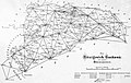 Dreiecksnetz sachsen.jpg 3,259 × 2,052; 1.22 MB
-
 Kgl.-sächs. Triangulirung, Station 140 Schönheide auf dem Kuhberg (Stützengrün).jpg 3,000 × 4,000; 4.53 MB
-

-

-

-

-

-

-

-

-

-

-

-

-
 Kuhberg 060.jpg 1,107 × 1,497; 1.05 MB
-
 Mobilfunk-Sendemast Kuhberg (Stützengrün) (19).jpg 3,456 × 2,304; 3.62 MB

.jpg)
_Aussichtsturm_und_Blockhaus_von_1894_Triangulationss%C3%A4ule_von_1876_(10).jpg)
_Aussichtsturm_und_Blockhaus_von_1894_Triangulationss%C3%A4ule_von_1876_(15).jpg)
_Aussichtsturm_und_Blockhaus_von_1894_Triangulationss%C3%A4ule_von_1876_(16).jpg)
_Aussichtsturm_und_Blockhaus_von_1894_Triangulationss%C3%A4ule_von_1876_(17).jpg)
_Aussichtsturm_und_Blockhaus_von_1894_Triangulationss%C3%A4ule_von_1876_(18).jpg)
_Aussichtsturm_und_Blockhaus_von_1894_Triangulationss%C3%A4ule_von_1876_(19).jpg)
_Aussichtsturm_und_Blockhaus_von_1894_Triangulationss%C3%A4ule_von_1876_(20).jpg)
_Aussichtsturm_und_Blockhaus_von_1894_Triangulationss%C3%A4ule_von_1876_(21).jpg)
_Aussichtsturm_und_Blockhaus_von_1894_Triangulationss%C3%A4ule_von_1876_(30).jpg)
_Aussichtsturm_und_Blockhaus_von_1894_Triangulationss%C3%A4ule_von_1876_(32).jpg)
_Aussichtsturm_und_Blockhaus_von_1894_Triangulationss%C3%A4ule_von_1876_(33).jpg)

_Aussichtsturm_und_Blockhaus_von_1894_Triangulationss%C3%A4ule_von_1876_(11).jpg)