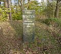
Category:Königlich-Sächsische Triangulirung Station 42 Rothstein
| (Wikidata) |
| Object location | | View all coordinates using: OpenStreetMap |
|---|
Triangulation Column, 2nd Order Station, the Royal Saxon Triangulation in Saxony 1862-1890  | |||||
| Upload media | |||||
| Instance of |
| ||||
|---|---|---|---|---|---|
| Part of | |||||
| Location | Rosenbach, Görlitz, Saxony, Germany | ||||
| Street address |
| ||||
| Heritage designation | |||||
| Inception |
| ||||
 | |||||
Media in category "Königlich-Sächsische Triangulirung Station 42 Rothstein"
The following 3 files are in this category, out of 3 total.
-
 Rosenbach Bischdorf Triangulationssäule 2. Ordnung.jpg 3,000 × 4,000; 2.28 MB
-
 Rotstein Nagelsche Säule.jpg 3,006 × 2,678; 1.93 MB
-
 Station 42 Rothstein.jpg 1,500 × 2,100; 1.05 MB

