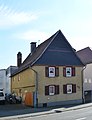
Category:Köpperner Straße 110
This is the category of the Hessian Kulturdenkmal (cultural monument) with the ID Unknown? (Wikidata)
|
| Object location | | View all coordinates using: OpenStreetMap |
|---|
| Upload media | |||||
| Instance of | |||||
|---|---|---|---|---|---|
| Location | Friedrichsdorf, Hochtaunuskreis, Darmstadt Government Region, Hesse, Germany | ||||
 | |||||
Media in category "Köpperner Straße 110"
The following 2 files are in this category, out of 2 total.
-
 Köppern, Köpperner Straße 110 (1).JPG 3,212 × 4,862; 7.22 MB
-
 Köppern, Köpperner Straße 110.JPG 2,838 × 3,696; 3.74 MB
.JPG)
