Category:Kaathoven 19, Vinkel
| Object location | | View all coordinates using: OpenStreetMap |
|---|
farmhouse in 's-Hertogenbosch, Netherlands  | |||||
| Upload media | |||||
| Instance of | |||||
|---|---|---|---|---|---|
| Location | Vinkel, Bernheze, North Brabant, Netherlands | ||||
| Located on street |
| ||||
| Heritage designation |
| ||||
 | |||||
Nederlands: Voormalige Sint-Cunerakapel - anno 1535
|
This is a category about rijksmonument number 9435
|
| Address |
|
Media in category "Kaathoven 19, Vinkel"
The following 4 files are in this category, out of 4 total.
-
 Aanzicht, Kaathoven 32 - Kaathoven - 20121499 - RCE.jpg 1,200 × 967; 321 KB
-

-

-
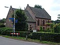 Vinkel, chapelle Cunera.JPG 3,072 × 2,304; 2.87 MB


