Category:Kaitawa bridge
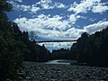
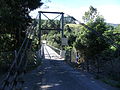
This suspension bridge connects the Otaki Gorge road on the true left side of the Otaki River to the Kaitawa, Parenga and Waihoanga roads at the right side.
| Object location | | View all coordinates using: OpenStreetMap |
|---|
truss bridge in Kaitawa, New Zealand  | |||||
| Upload media | |||||
| Instance of | |||||
|---|---|---|---|---|---|
| Location | Kaitawa, Tararua District, Manawatū-Whanganui Region, New Zealand | ||||
| Heritage designation |
| ||||
 | |||||
Media in category "Kaitawa bridge"
The following 4 files are in this category, out of 4 total.
-
 Kaitawa bridge 1.jpg 2,048 × 1,536; 1.05 MB
-
 Kaitawa bridge 2.jpg 2,048 × 1,536; 1.34 MB
-
 Kaitawa bridge 3.jpg 1,536 × 2,048; 1.45 MB
-
 Kaitawa bridge 4.jpg 1,536 × 2,048; 1.61 MB


