Category:Kanna, Gunma
日本語:日本国群馬県多野郡神流町に関するカテゴリ。
town in Tano district, Gunma prefecture, Japan     | |||||
| Upload media | |||||
| Instance of | |||||
|---|---|---|---|---|---|
| Location |
| ||||
| Legal form |
| ||||
| Inception |
| ||||
| Population |
| ||||
| Area |
| ||||
| Replaces |
| ||||
| Different from | |||||
| official website | |||||
 | |||||
Subcategories
This category has the following 4 subcategories, out of 4 total.
Media in category "Kanna, Gunma"
The following 42 files are in this category, out of 42 total.
-
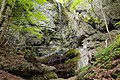
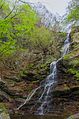 Azukinotaki fall.jpg 3,264 × 4,928; 2.62 MB
-
 Emblem of Kanna, Gunma.jpg 383 × 381; 19 KB
-
 Emblem of Kanna, Gunma.svg 300 × 300; 988 bytes
-
 Emblem of Manba, Gunma.svg 80 × 80; 1 KB
-
 Flag of Kanna Gunma.JPG 324 × 216; 9 KB
-
 Flag of Kanna Gunma.svg 900 × 600; 875 bytes
-
 Fudoumyouou at mt.mikabo.jpg 2,000 × 1,333; 838 KB
-
 Hayataki fall.jpg 2,000 × 1,333; 771 KB
-
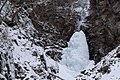 Hayataki icefall.jpg 2,000 × 1,333; 726 KB
-
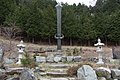 Hoko monument at mt.mikabo.jpg 2,000 × 1,333; 750 KB
-
 Irisawafudou.jpg 1,999 × 1,333; 530 KB
-
 Irisawanotaki fall.jpg 2,000 × 1,333; 1 MB
-
 Irisawanotaki hokora.jpg 2,000 × 1,333; 647 KB
-
 Kagahara, Kanna, Tano District, Gunma Prefecture 370-1602, Japan - panoramio.jpg 1,600 × 1,200; 1.11 MB
-
 Kanna in Gunma Prefecture Ja.svg 501 × 523; 11 KB
-
 Kanna Koinobori Festival 2014 1 (cropped).jpg 4,204 × 669; 522 KB
-
 Kanna Koinobori Festival 2014 1.jpg 4,204 × 3,149; 1.9 MB
-
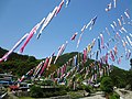 Kanna Koinobori Festival 2014 2.jpg 4,608 × 3,456; 1.44 MB
-
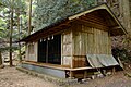
 Kanna Nakasato Town Hall 2009.jpg 2,602 × 1,860; 1.62 MB
-
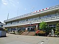 Kanna town office.jpg 4,572 × 3,406; 1.34 MB
-
 Manba High School.JPG 2,816 × 1,880; 2.17 MB
-
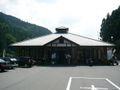 Michinoeki manba no sato.jpg 1,280 × 960; 560 KB
-
 Mikabo Forest Road 2.JPG 1,280 × 960; 226 KB
-
 Mt.kanou at kanna.jpg 2,000 × 1,333; 366 KB
-
 Population distribution of Kanna, Gunma, Japan.svg 512 × 256; 22 KB
-
 Route299-462-Kanna-Hirahara.jpg 1,200 × 900; 248 KB
-
 Route299-Kanna-Mitsukawa.jpg 900 × 1,200; 262 KB
-
 Sazanami iwa at kannamachi.jpg 2,000 × 1,333; 528 KB
-
 Shiramizu fall at kanna.jpg 2,000 × 1,333; 976 KB
-
 Yonoo, Kanna, Tano District, Gunma Prefecture 370-1601, Japan - panoramio (1).jpg 1,600 × 1,200; 534 KB
-
 Yonoo, Kanna, Tano District, Gunma Prefecture 370-1601, Japan - panoramio (2).jpg 1,600 × 1,200; 758 KB
-
 Yonoo, Kanna, Tano District, Gunma Prefecture 370-1601, Japan - panoramio (3).jpg 1,600 × 1,200; 533 KB
-
 Yonoo, Kanna, Tano District, Gunma Prefecture 370-1601, Japan - panoramio (4).jpg 1,600 × 1,200; 846 KB
-
 Yonoo, Kanna, Tano District, Gunma Prefecture 370-1601, Japan - panoramio.jpg 1,600 × 1,200; 919 KB
-
 叶山鉱山 - panoramio.jpg 1,600 × 1,200; 1,013 KB
-
 林道から塚山 - panoramio.jpg 2,288 × 1,712; 751 KB
-
 林道入り口から - panoramio.jpg 2,288 × 1,712; 835 KB
-
 林道終点付近のパラボラアンテナ - panoramio.jpg 2,288 × 1,712; 835 KB
-
 神流町・旧境界.png 80 × 50; 335 bytes
-
 群馬県多野郡万場町.png 188 × 158; 13 KB
-
 群馬県多野郡中里村.png 188 × 158; 13 KB
-
 赤久縄山頂 - panoramio.jpg 1,200 × 1,600; 460 KB


.jpg)
.jpg)
.jpg)
.jpg)


.jpg)