Category:Kapelle Heilige Familie (Mühlebach)
| Object location | | View all coordinates using: OpenStreetMap |
|---|
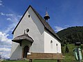
chapel building in Mühlebach in the municipality of Ernen in the canton of Valais, Switzerland  | |||||
| Upload media | |||||
| Instance of | |||||
|---|---|---|---|---|---|
| Part of | |||||
| Location | |||||
| Street address |
| ||||
| Heritage designation | |||||
 | |||||
Media in category "Kapelle Heilige Familie (Mühlebach)"
The following 8 files are in this category, out of 8 total.
-
 Ernen Mühlebach Hl Familie 02.JPG 2,112 × 2,816; 1.05 MB
-
 Ernen Mühlebach Hl Familie.JPG 2,816 × 2,112; 1.04 MB
-
 Kapelle Heilige Familie.jpg 5,029 × 3,014; 10.75 MB
-
 Kapelle Heilige Familie3.JPG 5,472 × 3,648; 4.46 MB
-
 St.Josef Hl Familie Mühlebach.JPG 4,352 × 2,448; 885 KB
-
 Views of Mühlebach from Ernen-02.jpg 2,061 × 2,233; 807 KB
-
 Views of Mühlebach from Ernen-04.jpg 4,503 × 2,006; 2.06 MB
-
 Views of Mühlebach from Ernen-06.jpg 4,355 × 2,195; 1.48 MB


