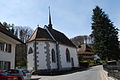
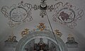
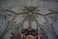
Category:Kapelle St. Beatus, Sensebrücke
| Object location | | View all coordinates using: OpenStreetMap |
|---|
_118.JPG) | |||||
| Upload media | |||||
| Instance of | |||||
|---|---|---|---|---|---|
| Part of | |||||
| Location |
| ||||
| Street address |
| ||||
| Heritage designation | |||||
 | |||||
Media in category "Kapelle St. Beatus, Sensebrücke"
The following 34 files are in this category, out of 34 total.
-
 2012-04-26 Sense-Sarino (Foto Dietrich Michael Weidmann) 118.JPG 3,872 × 2,592; 3.61 MB
-
 2012-04-26 Sense-Sarino (Foto Dietrich Michael Weidmann) 123.JPG 3,872 × 2,592; 3.63 MB
-
 Sankt Beatus Flamatt (3).jpg 1,944 × 2,592; 985 KB
-
 Sankt Beatus Flamatt.jpg 1,944 × 2,592; 919 KB
-
 St.Beatus Sensebrück Innen 01.jpg 3,294 × 4,804; 830 KB
-
 St.Beatus Sensebrück Innen 02.jpg 3,323 × 4,703; 815 KB
-
 St.Beatus Sensebrück Innen 03.jpg 5,217 × 3,138; 985 KB
-
 St.Beatus Sensebrück Innen 04.jpg 6,000 × 4,000; 1.54 MB
-
 St.Beatus Sensebrück Innen 05.jpg 6,000 × 4,000; 1.64 MB
-
 St.Beatus Sensebrück Innen 06.jpg 6,000 × 4,000; 1.39 MB
-
 St.Beatus Sensebrück Innen 07.jpg 6,000 × 4,000; 1.56 MB
-
 St.Beatus Sensebrück Innen 08.jpg 6,000 × 4,000; 1.65 MB
-
 St.Beatus Sensebrück Innen 09.jpg 3,568 × 5,481; 1.4 MB
-
 St.Beatus Sensebrück Innen 10.jpg 3,481 × 5,654; 1.14 MB
-
 St.Beatus Sensebrück Innen 11.jpg 3,357 × 5,470; 1.92 MB
-
 St.Beatus Sensebrück Innen 12.jpg 3,236 × 5,640; 1.07 MB
-
 St.Beatus Sensebrück Innen 13.jpg 3,582 × 5,035; 1.1 MB
-
 St.Beatus Sensebrück Innen 14.jpg 4,541 × 3,471; 1.07 MB
-
 St.Beatus Sensebrück Innen 15.jpg 4,953 × 3,745; 1.31 MB
-
 St.Beatus Sensebrück Innen 16.jpg 4,000 × 6,000; 1.42 MB
-
 St.Beatus Sensebrück Innen 17.jpg 4,000 × 6,000; 1.32 MB
-
 St.Beatus Sensebrück Innen 18.jpg 5,560 × 3,677; 1.3 MB
-
 St.Beatus Sensebrück Innen 19.jpg 5,060 × 3,452; 1.07 MB
-
 St.Beatus Sensebrück Innen 20.jpg 4,620 × 3,647; 974 KB
-
 St.Beatus Sensebrück Innen 21.jpg 5,677 × 3,647; 1.5 MB
-
 St.Beatus Sensebrück Innen 22.jpg 6,000 × 4,000; 1.79 MB
-
 St.Beatus Sensebrücke 01.jpg 4,707 × 3,461; 6.68 MB
-
 St.Beatus Sensebrücke 02.jpg 3,438 × 4,689; 10.22 MB
-
 St.Beatus Sensebrücke 03.jpg 5,491 × 3,706; 11 MB
-
 St.Beatus Sensebrücke 04.jpg 3,321 × 4,982; 7.51 MB
-
 St.Beatus Sensebrücke 05.jpg 5,938 × 3,959; 13.63 MB
-
 St.Beatus Sensebrücke 06.jpg 5,128 × 3,589; 12.39 MB
-
 St.Beatus Sensebrücke 07.jpg 5,439 × 3,763; 13.57 MB
-
 St.Beatus Sensebrücke 08.jpg 3,688 × 5,532; 11.62 MB
_123.JPG)
.jpg)


