Category:Kapelle Vollmannsdorf
| Object location | | View all coordinates using: OpenStreetMap |
|---|
cultural heritage monument D-4-71-120-82 (0) in Burgebrach, Bavaria .jpg) | |||||
| Upload media | |||||
| Instance of | |||||
|---|---|---|---|---|---|
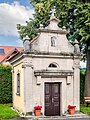
| Location | Burgebrach, Bamberg, Upper Franconia, Bavaria, Germany | ||||
| Street address |
| ||||
| Heritage designation | |||||
 | |||||
This is the category of the Bavarian Baudenkmal (cultural heritage monument) with the ID D-4-71-120-82 (Wikidata)
|
Media in category "Kapelle Vollmannsdorf"
The following 8 files are in this category, out of 8 total.
-
 Vollmannsdorf Kapelle (01).jpg 3,384 × 4,496; 3.22 MB
-
 Vollmannsdorf Kapelle (02).jpg 3,745 × 4,291; 3.66 MB
-
 Vollmannsdorf Kapelle (03).jpg 3,688 × 5,168; 4.05 MB
-
 Vollmannsdorf Kapelle-20160703-RM-151423.jpg 3,456 × 4,608; 8.79 MB
-
 Vollmannsdorf, Kapelle D-4-71-120-82 Burgebrach 20221229 0012.jpg 4,199 × 5,497; 33.65 MB
-
 Vollmannsdorf, Kapelle D-4-71-120-82 Burgebrach 20221229 0013.jpg 5,519 × 3,562; 27.38 MB
-
 Vollmannsdorf, Kapelle D-4-71-120-82 Burgebrach 20221229 0014.jpg 5,560 × 3,846; 25.72 MB
-
 Vollmannsdorf, Kapelle D-4-71-120-82 Burgebrach 20221229 0015.jpg 6,048 × 4,024; 45.66 MB
.jpg)
.jpg)


