Category:Karl-der-Große-Straße 09 (Barum)
This is the category for an architectural monument.
It is on the list of cultural monuments of Barum.
|
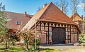
Sacristan and school building, built from 1769 to 1923
- Farm part of a Zweiständerhaus with sub-frame under hipped roof in hollow pantile roofing
- Timber framing with brick infill
- The east-facing service gable with pairs of symmetrically arranged head struts
- Changed in the area of the lateral room extensions due to additional gateways
- Living quarter and schoolroom replaced or extended by transverse brick building under half hipped roof with hollow pantile roofing
Sacristan and school building in Barum, Lower Saxony, Germany  | |||||
| Upload media | |||||
| Instance of | |||||
|---|---|---|---|---|---|
| Location | Barum, Lüneburg, Lower Saxony, Germany | ||||
| Heritage designation | |||||
 | |||||
Media in category "Karl-der-Große-Straße 09 (Barum)"
The following 2 files are in this category, out of 2 total.
-
 Barum Karl der Große Straße 09 001 2023 04 02-Verbessert-RR.jpg 5,277 × 3,197; 6.25 MB
-
 Barum Karl der Große Straße 09 002 2023 04 02.jpg 5,071 × 2,949; 5.29 MB
