Category:Kasteel Hilligersberg
| Object location | | View all coordinates using: OpenStreetMap |
|---|
 | |||||
| Upload media | |||||
| Instance of | |||||
|---|---|---|---|---|---|
| Location | Rotterdam, South Holland, Netherlands | ||||
| Street address |
| ||||
| Heritage designation |
| ||||
 | |||||
|
This is a category about rijksmonument number 32897
|
| Address |
|
Nederlands: Het Huis ten Berghe (ook bekend als kasteel van Hillegersberg)
Media in category "Kasteel Hilligersberg"
The following 40 files are in this category, out of 40 total.
-
-
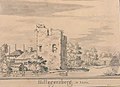
 Atlas Schoemaker-ZUIDHOLLAND-DEEL3-1777-Zuid-Holland, Hillegersberg.jpeg 956 × 1,656; 264 KB
-
 Atlas Schoemaker-ZUIDHOLLAND-DEEL3-1779-Zuid-Holland, Hillegersberg.jpeg 1,038 × 1,664; 317 KB
-
 Exterieur OVERZICHT GESMEED HEK, GRAF MEES DALEN - Hillegersberg - 20272749 - RCE.jpg 1,192 × 1,200; 369 KB
-
 Exterieur OVERZICHT GESMEED HEK, GRAF RUYS - Hillegersberg - 20272754 - RCE.jpg 1,188 × 1,200; 367 KB
-

-
 Hillegersberg.jpg 2,136 × 1,476; 478 KB
-

-

-
 Kasteelru‹ne, interieur noord muur - Hillegersberg - 20112821 - RCE.jpg 1,200 × 952; 292 KB
-
 Kasteelru‹ne, interieur noord-gevel - Hillegersberg - 20112820 - RCE.jpg 954 × 1,200; 316 KB
-
 Kasteelru‹ne, interieur zuid-west hoek - Hillegersberg - 20112822 - RCE.jpg 1,200 × 956; 230 KB
-
 Overzicht kerkhof met ruïne - Hillegersberg - 20112780 - RCE.jpg 1,195 × 1,200; 321 KB
-

-
 Rotterdam kerkstraat slotruine.jpg 2,800 × 2,119; 861 KB
-
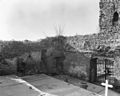
 Ruïne - Hillegersberg - 20112818 - RCE.jpg 894 × 1,200; 238 KB
-
 Ruïne, aanzicht - Hillegersberg - 20112704 - RCE.jpg 1,200 × 1,200; 291 KB
-
 Ruïne, aanzicht - Hillegersberg - 20112705 - RCE.jpg 1,184 × 1,200; 342 KB
-
 Ruïne, aanzicht - Hillegersberg - 20112706 - RCE.jpg 1,200 × 1,191; 277 KB
-
 Ruïne, aanzicht - Hillegersberg - 20112707 - RCE.jpg 1,200 × 1,193; 277 KB
-
 Ruïne, aanzicht - Hillegersberg - 20112708 - RCE.jpg 1,200 × 1,197; 400 KB
-
 Ruïne, aanzicht - Hillegersberg - 20112709 - RCE.jpg 1,200 × 1,200; 359 KB
-
 Ruïne, aanzicht - Hillegersberg - 20112710 - RCE.jpg 1,200 × 1,200; 366 KB
-
 Ruïne, aanzicht - Hillegersberg - 20112711 - RCE.jpg 1,188 × 1,200; 474 KB
-
 Ruïne, aanzicht - Hillegersberg - 20112712 - RCE.jpg 1,200 × 1,191; 363 KB
-
 Ruïne, aanzicht - Hillegersberg - 20112713 - RCE.jpg 1,186 × 1,200; 322 KB
-
 Ruïne, aanzicht - Hillegersberg - 20112714 - RCE.jpg 1,200 × 1,191; 438 KB
-
 Ruïne, aanzicht - Hillegersberg - 20112715 - RCE.jpg 1,200 × 1,200; 394 KB
-
 Toren ingang - Hillegersberg - 20112727 - RCE.jpg 852 × 1,200; 358 KB
-
 Voormalig kasteel, aanzicht - Hillegersberg - 20112716 - RCE.jpg 1,200 × 961; 242 KB
-
 Voormalig kasteel, aanzicht - Hillegersberg - 20112717 - RCE.jpg 1,200 × 952; 387 KB
-
 Voormalig kasteel, aanzicht - Hillegersberg - 20112718 - RCE.jpg 1,200 × 959; 303 KB
-
 Voormalig kasteel, aanzicht - Hillegersberg - 20112719 - RCE.jpg 1,200 × 963; 412 KB
-
 Voormalig kasteel, aanzicht - Hillegersberg - 20112720 - RCE.jpg 1,200 × 953; 339 KB
-
 Voormalig kasteel, aanzicht - Hillegersberg - 20112721 - RCE.jpg 1,200 × 960; 215 KB
-
 Voormalig kasteel, aanzicht - Hillegersberg - 20112722 - RCE.jpg 951 × 1,200; 348 KB
-
 Voormalig kasteel, aanzicht - Hillegersberg - 20112723 - RCE.jpg 1,200 × 952; 317 KB
-
 Voormalig kasteel, aanzicht - Hillegersberg - 20112724 - RCE.jpg 1,200 × 957; 217 KB
-
 Voormalig kasteel, aanzicht - Hillegersberg - 20112725 - RCE.jpg 961 × 1,200; 287 KB
-
 Zuid-zijde met kasteelru‹ne - Hillegersberg - 20112739 - RCE.jpg 1,200 × 962; 343 KB
.jpeg)


._Kopie_naar_een_tekening_van_Lois_uit_1672_-_Hillegersberg_-_20112726_-_RCE.jpg)


