Category:Kastellet - maps
Media in category "Kastellet - maps"
The following 9 files are in this category, out of 9 total.
-
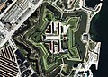 Aerial of Kastelletjpg.jpg 1,330 × 957; 549 KB
-
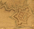 Kastellet - original layout, 1648.jpg 519 × 445; 42 KB
-
 Kastellet - sign.jpg 667 × 1,000; 677 KB
-
 Kastellet 1859.djvu 4,007 × 3,307; 1.25 MB
-
 Kastellet 1859.jpg 4,007 × 3,307; 2.99 MB
-
 Kastellet map, Copenhagen 145.jpg 1,419 × 1,900; 997 KB
-
 Kastelskirken Copenhagen Ruse plan.jpg 784 × 905; 346 KB
-
 Map of Kastellet.PNG 670 × 533; 21 KB
-
 Museum of Copenhagen - Kastellet.JPG 2,288 × 1,712; 858 KB


