Category:Kemmern
municipality of Germany    | |||||
| Upload media | |||||
| Instance of |
| ||||
|---|---|---|---|---|---|
| Part of |
| ||||
| Location | Bamberg, Upper Franconia, Bavaria, Germany | ||||
| Head of government |
| ||||
| Population |
| ||||
| Area |
| ||||
| Elevation above sea level |
| ||||
| official website | |||||
 | |||||
Media in category "Kemmern"
The following 9 files are in this category, out of 9 total.
-
 DEU Kemmern COA.svg 910 × 1,020; 110 KB
-
 Wappen Kemmern.png 115 × 124; 11 KB
-
 Digitales Orthofoto von Kemmern (Bayerische Vermessungsverwaltung).tif 12,500 × 12,500; 308.64 MB
-
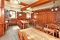 Gaststube Brauerei Wagner Kemmern.jpg 888 × 591; 579 KB
-
 Kemmern im Landkreis Bamberg.png 961 × 690; 16 KB
-
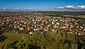 Kemmern Luftbild-20211016-RM-154708.jpg 5,463 × 3,190; 9.57 MB
-
 Kemmern Luftbild-20211016-RM-154954.jpg 5,423 × 3,613; 11.21 MB
-
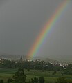 Kemmern mit Regenbogen 2006-06-01 klD.jpg 816 × 943; 144 KB
-
 Kemmern.png 330 × 240; 14 KB


