Category:Kill O' the Grange Abbey

|
This object is indexed in the Archaeological Survey of Ireland under SMR No. DU023-015001-
Geographic information system of the National Monuments Service: Historic Environment Viewer – Database record. |
church building in County Dublin, Ireland  | |||||
| Upload media | |||||
| Instance of | |||||
|---|---|---|---|---|---|
| Location | County Dublin, Leinster, Ireland | ||||
| Architectural style | |||||
| Diocese | |||||
| Heritage designation | |||||
 | |||||
Media in category "Kill O' the Grange Abbey"
The following 12 files are in this category, out of 12 total.
-
 Dean's Grange Road - geograph.org.uk - 6010356.jpg 800 × 533; 653 KB
-
 Kill O' the Grange Abbey 1.JPG 2,048 × 1,151; 421 KB
-
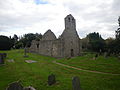 Kill O' the Grange Abbey 2.JPG 3,648 × 2,736; 1.71 MB
-
 Kill of Grange Church 1.JPG 6,016 × 4,000; 12.87 MB
-
 Kill of Grange Chutch front.JPG 6,016 × 4,000; 11.92 MB
-
 Kill of the grange church fr.2014.JPG 6,016 × 4,000; 12.82 MB
-
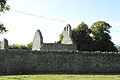 Kill of the Grange Church side.JPG 6,016 × 4,000; 11.39 MB
-
 Kill of the Grange Church.JPG 3,648 × 2,736; 4.82 MB
-
 Kill of the grange church2014.JPG 6,016 × 4,000; 12.48 MB
-
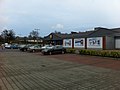 Lidl carpark - geograph.org.uk - 3377101.jpg 2,592 × 1,936; 1.81 MB
-
 Office building at Dun Laoghaire Industrial Estate - geograph.org.uk - 3377107.jpg 2,592 × 1,936; 1.53 MB
-
 Pottery Road intersection with Rochestown Avenue - geograph.org.uk - 3371668.jpg 2,592 × 1,936; 1.83 MB


