Category:Killean and Kilchenzie
civil parish in Argyll and Bute, Scotland, UK | |||||
| Upload media | |||||
| Instance of | |||||
|---|---|---|---|---|---|
| Part of |
| ||||
| Named after | |||||
| Location |
| ||||
| Population |
| ||||
| Area |
| ||||
 | |||||
Subcategories
This category has the following 2 subcategories, out of 2 total.
G
- Glenbarr Abbey (10 F)
Media in category "Killean and Kilchenzie"
The following 200 files are in this category, out of 430 total.
(previous page) (next page)-
 A derelict Arinanuan cottage - geograph.org.uk - 3486399.jpg 4,000 × 3,000; 2.96 MB
-
 A future birch glade - geograph.org.uk - 2011192.jpg 640 × 480; 94 KB
-

-
 A ruined Braids Farm - geograph.org.uk - 3840993.jpg 4,000 × 3,000; 2.69 MB
-
 A trig with a view - geograph.org.uk - 2011295.jpg 640 × 480; 97 KB
-
 A very wet moorland looking towards the forest - geograph.org.uk - 3841172.jpg 4,000 × 3,000; 3.29 MB
-
 A83 at Beachmenach - geograph.org.uk - 3367553.jpg 1,200 × 797; 362 KB
-
 A83 at Beachmenach - geograph.org.uk - 3367560.jpg 1,200 × 797; 401 KB
-
 A83 at Cleongart - geograph.org.uk - 3367563.jpg 1,200 × 797; 389 KB
-
 A83 at Killean, Kintyre - geograph.org.uk - 5858333.jpg 1,024 × 768; 90 KB
-
 A83 at Muasdale - geograph.org.uk - 3367559.jpg 1,200 × 797; 472 KB
-
 A83 at Putechan - geograph.org.uk - 5386295.jpg 800 × 534; 79 KB
-
 A83 at Tangy - geograph.org.uk - 5494721.jpg 640 × 481; 66 KB
-
 A83 heading north at Muasdale - geograph.org.uk - 5494773.jpg 640 × 481; 79 KB
-
 A83 heading to Tayinloan - geograph.org.uk - 5494788.jpg 640 × 455; 58 KB
-
 A83 near Ballure Farm - geograph.org.uk - 3368467.jpg 1,000 × 664; 220 KB
-
 A83 near Bellochantuy - geograph.org.uk - 5494750.jpg 640 × 479; 50 KB
-
 A83 near Glenbarr - geograph.org.uk - 3366627.jpg 1,200 × 797; 341 KB
-
 A83 near Lenaig - geograph.org.uk - 3368458.jpg 1,000 × 664; 264 KB
-
 A83 near Lenaig - geograph.org.uk - 5834851.jpg 1,024 × 576; 64 KB
-
 A83 near Putechan - geograph.org.uk - 5494742.jpg 640 × 481; 67 KB
-
 A83 near Tangy - geograph.org.uk - 5494728.jpg 640 × 481; 72 KB
-
 A83 north of Chleit - geograph.org.uk - 3106057.jpg 1,200 × 797; 478 KB
-
 A83 north of Glenbarr Village - geograph.org.uk - 5494763.jpg 640 × 535; 67 KB
-
 A83 north of Tayinloan - geograph.org.uk - 3368423.jpg 1,200 × 797; 307 KB
-
 A83 north of Tayinloan - geograph.org.uk - 5494794.jpg 640 × 481; 81 KB
-
 A83 through Muasdale - geograph.org.uk - 3106050.jpg 1,200 × 797; 439 KB
-
 A83, Tangy - geograph.org.uk - 4700431.jpg 800 × 450; 315 KB
-
 A83, Tayinloan - geograph.org.uk - 2924397.jpg 640 × 480; 357 KB
-
 Across the Sound of Gigha - geograph.org.uk - 2616807.jpg 640 × 436; 319 KB
-
 Allt Achadh a' Choirce - geograph.org.uk - 3841161.jpg 4,000 × 3,000; 3.88 MB
-
 Allt Chaltuinn - geograph.org.uk - 4878750.jpg 4,000 × 3,000; 4.06 MB
-
 Allt Mor and crags of Beinn Bhreac - geograph.org.uk - 3486407.jpg 4,000 × 3,000; 4.2 MB
-
 Allt Mòr an Laoigh, Kintyre - geograph.org.uk - 4605629.jpg 640 × 425; 83 KB
-

-
 Alltan Bàn, in the forest, Kintyre - geograph.org.uk - 2567835.jpg 640 × 425; 101 KB
-
 An infant Barr Water - geograph.org.uk - 3486394.jpg 4,000 × 3,000; 4.29 MB
-
 Approaching Muasdale from the south - geograph.org.uk - 5494768.jpg 640 × 481; 61 KB
-
 Arnicle farm - geograph.org.uk - 3486388.jpg 4,000 × 3,000; 3.17 MB
-
 Barlea from Victoria Hill - geograph.org.uk - 2011007.jpg 640 × 480; 96 KB
-
 Beach at Chleit - geograph.org.uk - 4062678.jpg 1,600 × 1,200; 479 KB
-
 Beach at Chleit - geograph.org.uk - 4062694.jpg 1,600 × 1,199; 287 KB
-
 Beach at Tayinloan - geograph.org.uk - 3808001.jpg 1,600 × 1,200; 270 KB
-
 Beach in front of Crubasdale Cottage - geograph.org.uk - 1952038.jpg 1,024 × 768; 304 KB
-
 Beach north of Tayinloan ferry terminal - geograph.org.uk - 3220962.jpg 640 × 427; 253 KB
-

-
 Beach, Point Sands, 1990 - geograph.org.uk - 5802957.jpg 800 × 539; 68 KB
-
 Bealach a' Chaochain - geograph.org.uk - 3225135.jpg 640 × 360; 223 KB
-
 Bellochantuy and Bellochantuy Bay - geograph.org.uk - 2692234.jpg 5,200 × 1,911; 7.06 MB
-
 Bellochantuy and Bellochantuy Bay - geograph.org.uk - 3661669.jpg 3,264 × 2,448; 4.48 MB
-
 Bellochantuy and Bellochantuy Bay - geograph.org.uk - 3752414.jpg 3,264 × 2,276; 4.69 MB
-
 Boathouse on Loch Arnicle - geograph.org.uk - 2011233.jpg 640 × 480; 97 KB
-
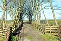
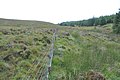
 Boundary fences - geograph.org.uk - 2011283.jpg 640 × 480; 95 KB
-
 Braids - geograph.org.uk - 2485807.jpg 600 × 400; 243 KB
-

-
 Bridge House, Muasdale - geograph.org.uk - 4926492.jpg 640 × 423; 66 KB
-
 Bridge over Strathduie Water - geograph.org.uk - 3592342.jpg 5,184 × 3,456; 7.01 MB
-
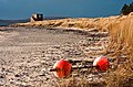 Buoys on Point Sands - geograph.org.uk - 1751532.jpg 640 × 419; 302 KB
-
 Buoys on Point Sands II - geograph.org.uk - 1751538.jpg 640 × 471; 294 KB
-
 Burn flows into Machrihanish Bay - geograph.org.uk - 5406011.jpg 1,200 × 1,600; 382 KB
-
 Car park at Westport - geograph.org.uk - 5494602.jpg 640 × 481; 49 KB
-
 Cara with Gigha and Islay behind - geograph.org.uk - 2779734.jpg 3,264 × 2,448; 3.41 MB
-
 Cattle grid on estate track above Killean - geograph.org.uk - 5858350.jpg 1,024 × 768; 91 KB
-
 Changing the light - Tayinloan - geograph.org.uk - 2525780.jpg 640 × 854; 303 KB
-
 Chleit - geograph.org.uk - 2924407.jpg 640 × 389; 216 KB
-
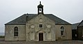
 Church at A' Chleit - geograph.org.uk - 1572389.jpg 640 × 480; 43 KB
-
 Clachaig Water, Kintyre - geograph.org.uk - 3106294.jpg 640 × 425; 91 KB
-
 Clachaig Water, Kintyre - geograph.org.uk - 936484.jpg 640 × 428; 67 KB
-
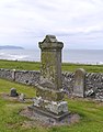
 Cladh nam Paitean (Burial Ground) - geograph.org.uk - 2618163.jpg 640 × 411; 220 KB
-
 Cladh nam Paitean - geograph.org.uk - 3288431.jpg 1,600 × 1,204; 346 KB
-
 Cladh nam Paitean - geograph.org.uk - 3753707.jpg 1,600 × 1,067; 327 KB
-
 Cladh nam Paitean Burial Ground - geograph.org.uk - 4578035.jpg 1,249 × 1,600; 472 KB
-
 Cladh nam Paitean Burial Ground - geograph.org.uk - 5494756.jpg 640 × 481; 64 KB
-
 Cleared forestry - geograph.org.uk - 2011290.jpg 640 × 480; 97 KB
-
 Cleared forestry - geograph.org.uk - 2011305.jpg 640 × 480; 96 KB
-

-
 Clifftop grazing - geograph.org.uk - 2010994.jpg 640 × 480; 97 KB
-
 Coast road from north into Muasdale - geograph.org.uk - 1955476.jpg 1,024 × 768; 245 KB
-
 Coastal Rocks - geograph.org.uk - 6202178.jpg 3,991 × 2,993; 3.55 MB
-
 Collusca Water below Braid Hill - geograph.org.uk - 4979890.jpg 4,000 × 3,000; 4.06 MB
-
 Corrylach - geograph.org.uk - 3592384.jpg 5,184 × 3,456; 7.14 MB
-
 Corrylach - geograph.org.uk - 3592394.jpg 1,600 × 1,067; 509 KB
-
 Course of Allt Achadh a' Choirce - geograph.org.uk - 3841181.jpg 4,000 × 3,000; 3.04 MB
-
 Course of an unnamed burn in the forest at Cnoc nan Agh - geograph.org.uk - 4979852.jpg 4,000 × 3,000; 3.74 MB
-
 Cruachan Beach - geograph.org.uk - 2616795.jpg 640 × 427; 302 KB
-
 Cruachan beach - geograph.org.uk - 3840895.jpg 4,000 × 3,000; 1.89 MB
-
 Dalkeith viewed from Victoria Hill - geograph.org.uk - 2010990.jpg 640 × 480; 96 KB
-
 Decayed reaper - geograph.org.uk - 1955235.jpg 1,024 × 768; 287 KB
-
 Deer-flattened grasses - geograph.org.uk - 2011197.jpg 640 × 430; 97 KB
-
 Derelict Building at Dalmore Farm - geograph.org.uk - 4693178.jpg 1,920 × 1,080; 1.29 MB
-
 Derelict house near Tayinloan - geograph.org.uk - 1572401.jpg 640 × 480; 98 KB
-
 Details of the bench mark on Cruach Mhic an t-Saoir - geograph.org.uk - 4889103.jpg 4,000 × 3,000; 4.62 MB
-
 Disused house at Blary - geograph.org.uk - 2011151.jpg 640 × 480; 96 KB
-
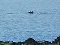 Dolphins at A'Chleit - geograph.org.uk - 3082312.jpg 800 × 602; 219 KB
-
 Down past Kilmory farm - geograph.org.uk - 2617957.jpg 640 × 427; 273 KB
-
 Dun Alluin - geograph.org.uk - 2618102.jpg 640 × 427; 311 KB
-
 Dunes, Westport - geograph.org.uk - 4241954.jpg 800 × 450; 145 KB
-
 Edge of the forest - geograph.org.uk - 2011253.jpg 640 × 480; 93 KB
-
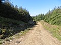
 Estate and forestry track above Killean - geograph.org.uk - 3840987.jpg 4,000 × 3,000; 2.43 MB
-
 Farm buildings at Langa - geograph.org.uk - 3367548.jpg 1,200 × 797; 338 KB
-
 Farm road to Balnagleck - geograph.org.uk - 3367544.jpg 1,200 × 797; 397 KB
-
 Farm road to Drumnamucklach - geograph.org.uk - 1955272.jpg 1,024 × 768; 261 KB
-
 Farm road to Glenacardoch - geograph.org.uk - 3366629.jpg 1,200 × 797; 363 KB
-
 Farm road to South Muasdale - geograph.org.uk - 3366620.jpg 1,200 × 797; 416 KB
-
 Farm track beside the Abhainn a' Chnocain - geograph.org.uk - 3486364.jpg 4,000 × 3,000; 3.95 MB
-
 Farm track near Ballure Farm - geograph.org.uk - 3368478.jpg 1,000 × 664; 331 KB
-
 Farm track near Low Ballevain - geograph.org.uk - 3367551.jpg 1,200 × 797; 397 KB
-
 Farmyard at Killocraw - geograph.org.uk - 1579091.jpg 640 × 480; 274 KB
-
 Fence separating the moor from the forest - geograph.org.uk - 3955745.jpg 4,000 × 3,000; 2.7 MB
-
 Fenceline across the moor near Braids Farm - geograph.org.uk - 3841140.jpg 4,000 × 3,000; 3.09 MB
-
 Fenceline on the moor - geograph.org.uk - 4889160.jpg 4,000 × 3,000; 2.91 MB
-
 Fenceline on the moor above the Allt na Muic - geograph.org.uk - 3486421.jpg 4,000 × 3,000; 4.03 MB
-
 Ferry Farm ^ Big Jessie's - geograph.org.uk - 5446734.jpg 3,264 × 2,448; 4.75 MB
-
 Ferry Terminal and shelter - geograph.org.uk - 5446737.jpg 3,264 × 2,448; 2.59 MB
-
 Ferry terminal at Tayinloan - geograph.org.uk - 5858344.jpg 1,024 × 576; 64 KB
-
 Fields below Victoria Hill - geograph.org.uk - 2010998.jpg 640 × 480; 97 KB
-
 Fields near Muasdale - geograph.org.uk - 3366630.jpg 1,200 × 797; 377 KB
-
 Firebreak in the forest - geograph.org.uk - 3841192.jpg 4,000 × 3,000; 4.44 MB
-
 Firebreak in the forest above Lussa Loch - geograph.org.uk - 4979841.jpg 4,000 × 3,000; 3.82 MB
-
 Firebreak in the forest at Cnoc nan Agh - geograph.org.uk - 4979856.jpg 4,000 × 3,000; 5.1 MB
-
 Fishing hut on the shore of Lussa Loch - geograph.org.uk - 4979845.jpg 4,000 × 3,000; 3.14 MB
-
 Foggy Westport - geograph.org.uk - 4973523.jpg 1,600 × 1,200; 297 KB
-
 Forest and Clachaig Water, Kintyre - geograph.org.uk - 941363.jpg 640 × 428; 92 KB
-
 Forest and moorland meet - geograph.org.uk - 3841144.jpg 4,000 × 3,000; 3.86 MB
-

-
 Forest at Tayinloan Burn, Kintyre - geograph.org.uk - 1456875.jpg 640 × 430; 107 KB
-
 Forest boundary - geograph.org.uk - 2011265.jpg 640 × 480; 97 KB
-

-
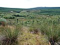
 Forest burn and young trees - geograph.org.uk - 2011186.jpg 640 × 480; 97 KB
-
 Forest clearing, Lorgie Hill, Kintyre - geograph.org.uk - 1457102.jpg 640 × 430; 107 KB
-
 Forest edge - geograph.org.uk - 1954720.jpg 1,024 × 768; 234 KB
-
 Forest edge below Cnoc na Craobh - geograph.org.uk - 3955741.jpg 4,000 × 3,000; 2.66 MB
-
 Forest edge from the moorland - geograph.org.uk - 4889180.jpg 4,000 × 3,000; 3.16 MB
-

-
 Forest fire break - geograph.org.uk - 2617832.jpg 510 × 640; 434 KB
-
 Forest fire-break, Kintyre - geograph.org.uk - 2032206.jpg 640 × 425; 116 KB
-
 Forest fire-break, Kintyre - geograph.org.uk - 2032315.jpg 640 × 425; 119 KB
-
 Forest fire-break, Kintyre - geograph.org.uk - 2032376.jpg 640 × 425; 99 KB
-

-
 Forest ride - geograph.org.uk - 2011323.jpg 640 × 480; 96 KB
-
 Forest road above Barr Water - geograph.org.uk - 4889193.jpg 4,000 × 3,000; 2.84 MB
-
 Forest road below Blary Hill - geograph.org.uk - 3486375.jpg 4,000 × 3,000; 3.8 MB
-
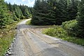 Forest road junction, Kintyre - geograph.org.uk - 2030251.jpg 640 × 425; 95 KB
-
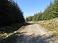
 Forest road, Kintyre - geograph.org.uk - 2032456.jpg 640 × 425; 107 KB
-

-
 Forest stream, Kintyre - geograph.org.uk - 2032529.jpg 640 × 425; 122 KB
-

-
 Forest track on the slopes of Braid Hill - geograph.org.uk - 4979892.jpg 4,000 × 3,000; 3.32 MB
-
 Forest track, Cruach Muasdale, Kintyre - geograph.org.uk - 2570464.jpg 640 × 425; 114 KB
-
 Forest track, Kintyre - geograph.org.uk - 2030541.jpg 640 × 425; 97 KB
-
 Forest track, Kintyre - geograph.org.uk - 2032421.jpg 640 × 425; 112 KB
-

-

-
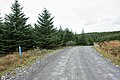
 Forest track, West Kintyre - geograph.org.uk - 1457082.jpg 640 × 430; 112 KB
-
 Forest, Clachaig Glen, Kintyre - geograph.org.uk - 941332.jpg 640 × 428; 100 KB
-
 Forest, Cruach Muasdale, Kintyre - geograph.org.uk - 941402.jpg 640 × 428; 117 KB
-

-
 Forest-Moorland boundary, Kintyre - geograph.org.uk - 2030277.jpg 640 × 425; 76 KB
-
 Forest-Moorland boundary, Kintyre - geograph.org.uk - 2030300.jpg 640 × 425; 84 KB
-
 Forestry extraction track, Kintyre - geograph.org.uk - 5855274.jpg 1,024 × 768; 105 KB
-
 Forestry road below Blary Hill - geograph.org.uk - 3486368.jpg 4,000 × 3,000; 3.36 MB
-
 Forestry south of Barr Glen - geograph.org.uk - 2011182.jpg 640 × 480; 97 KB
-
 Forwarded Timber near Loch Beag - geograph.org.uk - 5343276.jpg 1,200 × 675; 1,005 KB
-
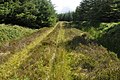
 Gap in the Forest, Kintyre - geograph.org.uk - 2030569.jpg 640 × 425; 97 KB
-
 Gate on forest access road - geograph.org.uk - 2011155.jpg 640 × 480; 98 KB
-
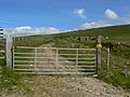 Gate to hillside grazing - geograph.org.uk - 1954708.jpg 1,024 × 768; 197 KB
-
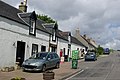 Glenbarr - geograph.org.uk - 1443419.jpg 640 × 428; 69 KB
-
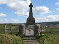 Glenbarr War Memorial - geograph.org.uk - 5724376.jpg 640 × 480; 73 KB
-

-
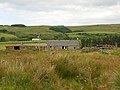
 Gobagrennan Farm at the southern end of Lussa Loch - geograph.org.uk - 4979838.jpg 4,000 × 3,000; 2.58 MB
-

-
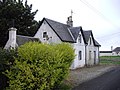
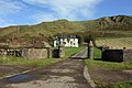
 Hazel's Cottage and Dalnaspidal - geograph.org.uk - 1603481.jpg 640 × 480; 313 KB
-
 Hazel's Cottage and Dalnaspidal - geograph.org.uk - 1603493.jpg 640 × 480; 300 KB
-
 High moorland, Cnoc Odhar Auchaluskin - geograph.org.uk - 1955223.jpg 1,024 × 768; 257 KB
-
 Highland Bull at High Bellochantuy Farm - geograph.org.uk - 6059397.jpg 4,032 × 2,268; 5.43 MB
-
 Holiday cottages at Drumnamucklach - geograph.org.uk - 1955266.jpg 1,024 × 768; 158 KB
-
 Junction of the Glenbarr road and the A83 - geograph.org.uk - 3366621.jpg 1,200 × 797; 337 KB
-
 Junction of tracks in the forest - geograph.org.uk - 4979884.jpg 4,000 × 3,000; 4 MB
-
 Kilchenzie graveyard - geograph.org.uk - 3770817.jpg 1,600 × 1,067; 332 KB
-
 Killarow Farm, Kintyre - geograph.org.uk - 3816016.jpg 1,024 × 699; 147 KB
-
 Killean Burn - geograph.org.uk - 2616712.jpg 640 × 427; 294 KB
-
-

-
 Killocraw Farm - geograph.org.uk - 1579089.jpg 640 × 480; 270 KB
-
 Kintyre Coast - geograph.org.uk - 2618166.jpg 640 × 423; 294 KB
-
 Kintyre coast, Killean - geograph.org.uk - 2107615.jpg 2,592 × 1,944; 2.17 MB
-
 Kintyre coastline near tangy Lodge - geograph.org.uk - 4196840.jpg 1,600 × 1,200; 438 KB
-
 Kintyre pasture - geograph.org.uk - 2924392.jpg 640 × 480; 266 KB
-
 Kintyre shoreline - geograph.org.uk - 3693868.jpg 1,600 × 1,203; 403 KB
-
 Kintyre Way - geograph.org.uk - 2617816.jpg 640 × 427; 311 KB
-
 Kintyre Way on a forest track along the shore of Lussa Loch - geograph.org.uk - 4979849.jpg 4,000 × 3,000; 3.78 MB
-
 Kintyre Way passing through forest - geograph.org.uk - 5855606.jpg 1,024 × 768; 231 KB
-
 Kintyre Way, North of Braids - geograph.org.uk - 5855609.jpg 1,024 × 768; 159 KB
-
 Lagalgarve Farm - geograph.org.uk - 1617443.jpg 640 × 480; 277 KB
-
 Lagloskine, Kintyre - geograph.org.uk - 1456957.jpg 640 × 430; 96 KB
-
 Landscape by Dun-Alluin - geograph.org.uk - 2618105.jpg 640 × 427; 306 KB
-
 Langa Farm - geograph.org.uk - 3661664.jpg 3,264 × 2,036; 4.7 MB
-
 Last fall on Allt Beachaire - geograph.org.uk - 3288415.jpg 1,600 × 1,274; 610 KB
-
 Leaving the forest - geograph.org.uk - 2617906.jpg 640 × 427; 311 KB
-
 Leth Uillt on the moor - geograph.org.uk - 3486214.jpg 4,000 × 3,000; 3.57 MB


_Highlanders_by_the_Allt_Beachaire_-_geograph.org.uk_-_3288419.jpg)


_-_geograph.org.uk_-_2618163.jpg)


