Category:Kindergarten und Volksschule, Siget in der Wart
| Object location | | View all coordinates using: OpenStreetMap |
|---|
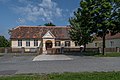
building in Rotenturm an der Pinka, Austria  | |||||
| Upload media | |||||
| Instance of | |||||
|---|---|---|---|---|---|
| Location | Rotenturm an der Pinka, Oberwart District, Burgenland, Austria | ||||
| Street address |
| ||||
| Heritage designation | |||||
 | |||||
Media in category "Kindergarten und Volksschule, Siget in der Wart"
The following 5 files are in this category, out of 5 total.
-
 20210821 WTSB Siget 5116.jpg 5,407 × 3,605; 14.56 MB
-
 20210821 WTSB Siget 5117.jpg 4,966 × 3,311; 11.33 MB
-
 20210821 WTSB Siget 5118.jpg 5,120 × 3,413; 12.01 MB
-
 Rotenturm Siget Evang Volksschule.jpg 4,592 × 3,056; 2.95 MB
-
 Siget in der Wart, evangelische Volksschule.jpg 6,000 × 4,000; 14.15 MB


