Category:Kippford
village in Dumfries and Galloway, Scotland, UK  | |||||
| Upload media | |||||
| Instance of | |||||
|---|---|---|---|---|---|
| Location |
| ||||
 | |||||
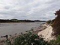
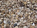
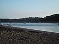
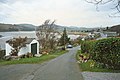
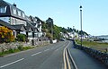
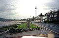
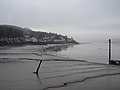
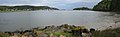
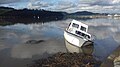
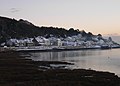
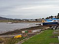
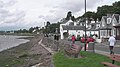
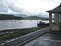
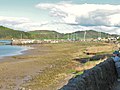
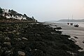
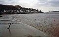
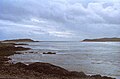
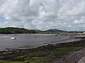
English: Kippford (otherwise Scaur) is a small village along the Solway coast, in Dumfries and Galloway, Scotland.
Subcategories
This category has only the following subcategory.
L
Media in category "Kippford"
The following 163 files are in this category, out of 163 total.
-
 A boat at Kippford - geograph.org.uk - 3483328.jpg 640 × 480; 180 KB
-
 A high tide - geograph.org.uk - 3778448.jpg 640 × 396; 88 KB
-
 A sandy bay at low tide - geograph.org.uk - 2486458.jpg 3,018 × 2,230; 1.26 MB
-
 A Sea of Pinks - geograph.org.uk - 1337468.jpg 640 × 480; 166 KB
-
 ABDAG006246 - Martin Hardie - Pier End, Kippford.jpeg 506 × 800; 72 KB
-
 Anchor Hotel on the waterfront at Kippford - geograph.org.uk - 2228272.jpg 3,134 × 2,350; 1.3 MB
-
 At Kippford Village Hall - geograph.org.uk - 1953490.jpg 600 × 800; 178 KB
-
 Barn at Auchenhill farm - geograph.org.uk - 1636001.jpg 640 × 469; 97 KB
-
 Beach at Kippford - geograph.org.uk - 2040323.jpg 640 × 427; 273 KB
-

-
 Boarded up Yachting Club Lookout - geograph.org.uk - 2040327.jpg 427 × 640; 288 KB
-
 Boat at Kippford - geograph.org.uk - 6248904.jpg 1,600 × 778; 193 KB
-
 Boat at Kippford - geograph.org.uk - 6273884.jpg 1,024 × 768; 312 KB
-
 Boat beside the slipway, Kippford - geograph.org.uk - 5159746.jpg 1,600 × 987; 374 KB
-
 Boat beside the slipway, Kippford - geograph.org.uk - 5159750.jpg 1,600 × 1,005; 281 KB
-
 Boat beside the slipway, Kippford - geograph.org.uk - 5395292.jpg 1,600 × 1,023; 293 KB
-
 Boat beside the Wee Pier, Kippford - geograph.org.uk - 5581761.jpg 1,600 × 1,028; 380 KB
-
 Boats at Kippford - geograph.org.uk - 5579353.jpg 1,600 × 1,024; 279 KB
-
 Boats at low tide, Kippford - geograph.org.uk - 1953458.jpg 800 × 600; 116 KB
-
 Boats beside the jetty, Kippford - geograph.org.uk - 5392531.jpg 1,600 × 1,200; 479 KB
-
 Boats laid up for the winter at Kippford sailing club - geograph.org.uk - 2228281.jpg 2,700 × 2,017; 1.89 MB
-
 Boats, Kippford - geograph.org.uk - 1953198.jpg 800 × 600; 140 KB
-
 Boulder, Below the Mote of Mark - geograph.org.uk - 2040454.jpg 640 × 427; 290 KB
-
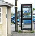
 Bus Shelter and Telephone Box, Kippford - geograph.org.uk - 2040339.jpg 640 × 427; 250 KB
-
 Bus shelter and telephone kiosk, Kippford - geograph.org.uk - 5159783.jpg 1,600 × 962; 243 KB
-
 Causeway to Rough Island - geograph.org.uk - 2486442.jpg 3,014 × 2,224; 1.61 MB
-
 Causeway to Rough Isle^ - geograph.org.uk - 4592492.jpg 1,600 × 1,064; 440 KB
-
 Chapman Stone - geograph.org.uk - 2040332.jpg 640 × 427; 310 KB
-
 Choppy Seas - geograph.org.uk - 3778446.jpg 640 × 472; 135 KB
-
 Coastal lane in Kippford - geograph.org.uk - 1953514.jpg 800 × 600; 191 KB
-
 Cockle beach - geograph.org.uk - 5160234.jpg 1,600 × 1,044; 389 KB
-
 Cockle beach - geograph.org.uk - 5160820.jpg 1,067 × 1,600; 539 KB
-
 Cockle beach, Kippford - geograph.org.uk - 5159862.jpg 1,600 × 1,067; 437 KB
-
 Cockle beach, Kippford - geograph.org.uk - 5159925.jpg 1,600 × 1,052; 423 KB
-
 Cockle Shell Beach and Rough Firth - geograph.org.uk - 5182058.jpg 1,066 × 800; 221 KB
-
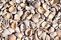
 Cockle shell beach at Kippford - geograph.org.uk - 382655.jpg 640 × 480; 91 KB
-
 Cockle shell beach at Kippford - geograph.org.uk - 4898377.jpg 800 × 600; 165 KB
-
 Cockle shell beach at Kippford - geograph.org.uk - 6514029.jpg 1,600 × 778; 481 KB
-
 Cockles on the beach, Kippford - geograph.org.uk - 5581201.jpg 1,200 × 1,600; 481 KB
-
 Common Cordgrass - geograph.org.uk - 2040429.jpg 640 × 427; 283 KB
-
 Cordgrass Control Measures, Rough Firth - geograph.org.uk - 2040427.jpg 640 × 427; 266 KB
-
 Dawn at Kippford - geograph.org.uk - 1081812.jpg 640 × 408; 36 KB
-
 Dumped rubble beside the Merse - geograph.org.uk - 5579251.jpg 1,600 × 988; 390 KB
-
 Edge of the merse, Kippford - geograph.org.uk - 5392638.jpg 1,600 × 1,200; 480 KB
-
 Evening Flood Tide, Kippford - geograph.org.uk - 978446.jpg 640 × 480; 62 KB
-
 Fishing boat at Kippford - geograph.org.uk - 6273869.jpg 1,024 × 768; 436 KB
-
 Foreshore upgrading at Kippford - geograph.org.uk - 4020029.jpg 4,608 × 3,456; 3.33 MB
-
 From the Slipway - geograph.org.uk - 3778468.jpg 640 × 427; 78 KB
-

-
 Grey sky over Kippford - geograph.org.uk - 5579223.jpg 1,600 × 1,035; 281 KB
-
 Grounded boat, Kippford - geograph.org.uk - 5579212.jpg 1,220 × 1,600; 351 KB
-
 House overlooking the Merse, Kippford - geograph.org.uk - 5579244.jpg 1,600 × 1,067; 408 KB
-
 Houses at Roughfirth - geograph.org.uk - 5160837.jpg 1,600 × 1,039; 568 KB
-
 Houses on Merse Way, Kippford - geograph.org.uk - 5579266.jpg 1,600 × 790; 293 KB
-
 Houses on Merse Way, Kippford - geograph.org.uk - 5579285.jpg 1,600 × 853; 309 KB
-
 Kippford (39501377241).jpg 5,892 × 2,970; 16.31 MB
-
 Kippford (42271746571).jpg 7,189 × 2,413; 5.4 MB
-
 Kippford - geograph.org.uk - 1366183.jpg 640 × 426; 85 KB
-
 Kippford - geograph.org.uk - 1953504.jpg 800 × 600; 139 KB
-
 Kippford - geograph.org.uk - 382658.jpg 640 × 480; 75 KB
-
 Kippford - geograph.org.uk - 5392548.jpg 1,600 × 1,021; 285 KB
-
 Kippford - geograph.org.uk - 5643125.jpg 2,946 × 1,485; 5.11 MB
-
 Kippford - geograph.org.uk - 5660592.jpg 1,280 × 853; 582 KB
-
 Kippford - geograph.org.uk - 813114.jpg 640 × 416; 69 KB
-
 Kippford at low tide - geograph.org.uk - 2810475.jpg 2,592 × 1,944; 1.68 MB
-
 Kippford Basin from Tornat Shoreline - geograph.org.uk - 1305588.jpg 640 × 199; 97 KB
-
 Kippford Beach - geograph.org.uk - 382660.jpg 640 × 480; 86 KB
-
 Kippford Boat - geograph.org.uk - 5574925.jpg 1,600 × 900; 222 KB
-
 Kippford from "Smoker's Rest" - geograph.org.uk - 1289088.jpg 640 × 480; 267 KB
-
 Kippford from South Glen Brae - geograph.org.uk - 1289093.jpg 640 × 480; 296 KB
-
 Kippford in the snow - geograph.org.uk - 2218907.jpg 2,864 × 2,051; 1.91 MB
-
 Kippford on Rough Firth - geograph.org.uk - 2931665.jpg 3,980 × 2,642; 1.52 MB
-
 Kippford steps - geograph.org.uk - 2145607.jpg 1,600 × 1,200; 867 KB
-
 Kippford waterfront - geograph.org.uk - 2145617.jpg 1,600 × 1,200; 349 KB
-
 Kippford waterfront in the snow - midday Christmas Day 2010 - geograph.org.uk - 2217689.jpg 3,984 × 2,988; 3.02 MB
-
 Kippford, no through road - geograph.org.uk - 2145593.jpg 1,600 × 1,200; 563 KB
-
 Kippford, Scotland.jpg 3,072 × 1,728; 1.27 MB
-
 Kippfordsunset.jpg 916 × 786; 499 KB
-

-
 Looking across Urr Water at Kippford - geograph.org.uk - 2486635.jpg 2,727 × 2,067; 1.01 MB
-
 Looking south from Kippford - geograph.org.uk - 4217739.jpg 3,264 × 2,448; 2.46 MB
-
 Looking towards Isle Point - geograph.org.uk - 2486605.jpg 3,026 × 2,242; 1.24 MB
-
 Looking towards Rough Island - geograph.org.uk - 1933550.jpg 2,520 × 1,866; 1.17 MB
-
 Looking towards the Yacht Club, Kippford - geograph.org.uk - 1933519.jpg 2,048 × 1,536; 748 KB
-
 Looking West - geograph.org.uk - 3778475.jpg 640 × 427; 133 KB
-
 Low tide at Kippford - geograph.org.uk - 4217738.jpg 3,264 × 2,448; 2.23 MB
-
 Low tide at Kippford - geograph.org.uk - 4758103.jpg 3,504 × 2,336; 3.11 MB
-
 Low tide at Rough Firth - geograph.org.uk - 2486475.jpg 3,034 × 2,252; 1.24 MB
-
 Low tide looking across Rough Firth - geograph.org.uk - 2486482.jpg 3,048 × 2,272; 1.27 MB
-
 Low tide, Kippford - geograph.org.uk - 5581732.jpg 1,600 × 1,067; 290 KB
-
 Low tide, Rough Firth - geograph.org.uk - 5581716.jpg 1,600 × 1,067; 448 KB
-
 Low tide, Urr Water - geograph.org.uk - 5581727.jpg 1,600 × 1,196; 322 KB
-
 Mud flats at Kippford - geograph.org.uk - 1366688.jpg 640 × 398; 70 KB
-
 No Parking - it's for turning only - geograph.org.uk - 2486505.jpg 3,072 × 2,304; 2.35 MB
-
 Odd sculptures at Kippford - geograph.org.uk - 1953148.jpg 800 × 600; 218 KB
-
 Parking on the front at Kippford - geograph.org.uk - 2486403.jpg 3,058 × 2,286; 949 KB
-
-
 Pontoon, Kippford - geograph.org.uk - 6485776.jpg 1,024 × 625; 168 KB
-
 River bank with boats drawn up - geograph.org.uk - 261957.jpg 640 × 419; 76 KB
-
 Rock Garden - geograph.org.uk - 1953177.jpg 800 × 600; 271 KB
-
 Rocky foreshore looking up Rough Firth - geograph.org.uk - 2486554.jpg 3,040 × 2,262; 1.37 MB
-
 Rocky shoreline near Kippford - geograph.org.uk - 6679077.jpg 1,600 × 778; 294 KB
-
 Rough Firth - geograph.org.uk - 5182067.jpg 1,066 × 800; 220 KB
-
 Rough Firth at Kippford - geograph.org.uk - 1102536.jpg 640 × 480; 89 KB
-
 Rough Firth below Muckle Lands - geograph.org.uk - 6273657.jpg 1,024 × 768; 407 KB
-
 Rough Firth, Kippord - geograph.org.uk - 3896750.jpg 1,066 × 800; 148 KB
-
-
 Seafront shelter, Kippford - geograph.org.uk - 1383446.jpg 640 × 468; 56 KB
-
 Shell Beach Kippford.jpg 6,000 × 4,000; 14.8 MB
-
 Shells on the foreshore - geograph.org.uk - 2486495.jpg 3,028 × 2,244; 1.84 MB
-
 Shore at Roughfirth - geograph.org.uk - 5581708.jpg 1,600 × 1,010; 374 KB
-
 Shore near Chapman's Stone, Kippford - geograph.org.uk - 5160226.jpg 1,600 × 1,067; 395 KB
-
 Shoreline at Kippford - geograph.org.uk - 1366228.jpg 640 × 371; 95 KB
-
 Shoreline Oak - geograph.org.uk - 1305525.jpg 640 × 476; 297 KB
-
 Shoreline Oaks - geograph.org.uk - 1305559.jpg 640 × 480; 300 KB
-
 Slipway by the Rough Firth - geograph.org.uk - 2486424.jpg 3,010 × 2,220; 1.17 MB
-
 Southeast from North Glen - geograph.org.uk - 1277837.jpg 640 × 480; 55 KB
-
 Survey vessel - geograph.org.uk - 2145499.jpg 1,600 × 1,200; 452 KB
-
 Telephone box, Kippford - geograph.org.uk - 1383449.jpg 629 × 640; 89 KB
-
 The (only^) village shop in Kippford, Dumfries - geograph.org.uk - 2228371.jpg 3,209 × 2,321; 2.02 MB
-
 The Ark - geograph.org.uk - 774847.jpg 640 × 482; 82 KB
-
 The Ark, Kippford - geograph.org.uk - 5159829.jpg 1,600 × 1,233; 323 KB
-
 The Estuary at Kippford - geograph.org.uk - 6149094.jpg 2,976 × 1,984; 2.8 MB
-
 The Estuary at Kippford - geograph.org.uk - 6149115.jpg 2,976 × 1,984; 3.79 MB
-
 The estuary at Kippford - geograph.org.uk - 941141.jpg 640 × 480; 65 KB
-
 The estuary at Kippford - geograph.org.uk - 941360.jpg 640 × 480; 97 KB
-
 The river at Kippford - geograph.org.uk - 927794.jpg 640 × 480; 70 KB
-
 The Rough Firth - geograph.org.uk - 3778465.jpg 640 × 391; 106 KB
-
 The Rough Firth at Kippford - geograph.org.uk - 1102545.jpg 640 × 480; 93 KB
-
 The shore at Kippford - geograph.org.uk - 5395272.jpg 1,600 × 1,000; 297 KB
-
 The Urr Water at Kippford - geograph.org.uk - 1366256.jpg 640 × 413; 105 KB
-
 The Urr Water at Kippford - geograph.org.uk - 6296178.jpg 1,024 × 521; 95 KB
-
 The village shop, Kippford - geograph.org.uk - 2486392.jpg 3,018 × 2,230; 1.2 MB
-
 The Yacht Club, Kippford - geograph.org.uk - 1933506.jpg 2,482 × 1,812; 879 KB
-
 Turning area at the end of the road - geograph.org.uk - 2486436.jpg 3,072 × 2,304; 1.77 MB
-
 Unusual house overlooking the firth at Kippford - geograph.org.uk - 2228277.jpg 3,264 × 2,448; 2.07 MB
-
 Upriver from above Gibbs Hole Wood - geograph.org.uk - 1280539.jpg 640 × 480; 91 KB
-
 Upriver from Glenview, Kippford - geograph.org.uk - 1274061.jpg 640 × 303; 39 KB
-
 Urr Bends - geograph.org.uk - 1274069.jpg 640 × 193; 38 KB
-
 Urr Water , Kipford - geograph.org.uk - 297153.jpg 640 × 300; 22 KB
-
 Urr Water - geograph.org.uk - 774823.jpg 640 × 453; 43 KB
-
 Urr Water, Kippford - geograph.org.uk - 5159713.jpg 1,600 × 1,067; 328 KB
-
 View across the rocks - geograph.org.uk - 5160229.jpg 1,600 × 933; 376 KB
-

-
 View of Rough Firth - geograph.org.uk - 6487601.jpg 1,564 × 1,031; 526 KB
-

-
 Walking on Rough Firth - geograph.org.uk - 4163990.jpg 3,660 × 2,376; 5.63 MB
-
 Walkway and pontoon, Kippford - geograph.org.uk - 5159768.jpg 1,600 × 1,067; 314 KB
-
 Walkway and pontoon, Kippford - geograph.org.uk - 5161183.jpg 1,600 × 983; 370 KB
-
 Water of Urr - geograph.org.uk - 1933531.jpg 2,476 × 1,804; 849 KB
-
 Water of Urr - geograph.org.uk - 1933535.jpg 1,814 × 1,365; 640 KB
-
 Waterfront at Kippord - geograph.org.uk - 3897170.jpg 1,066 × 800; 223 KB
-
 Wee Pier, Kippford - geograph.org.uk - 5581770.jpg 1,067 × 1,600; 549 KB
-
 Whim Cottage - geograph.org.uk - 5392915.jpg 1,600 × 974; 292 KB
-
 Whim Cottage, Kippford - geograph.org.uk - 5579194.jpg 1,600 × 1,067; 287 KB
-
 Whim Cottage, Kippford - geograph.org.uk - 6745110.jpg 1,024 × 498; 100 KB
-
 Winter in Kippford - geograph.org.uk - 3778458.jpg 640 × 391; 82 KB
-
 Forestry road - geograph.org.uk - 262233.jpg 640 × 407; 81 KB
-
 Moorings at Kippford from the Jetty. - geograph.org.uk - 155729.jpg 640 × 409; 89 KB
-
 Stone Heads at Kippford - geograph.org.uk - 259194.jpg 640 × 393; 96 KB
-
 The Anchor Hotel, Kipford - geograph.org.uk - 297156.jpg 640 × 480; 93 KB
-
 View of Horses Isles and Rough Island - geograph.org.uk - 94368.jpg 640 × 480; 72 KB
-


.jpg)


_village_shop_in_Kippford,_Dumfries_-_geograph.org.uk_-_2228371.jpg)


_-_geograph.org.uk_-_14421.jpg)
.jpg)