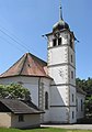
Category:Kirche St. Gallus (Kirchweg, Hochwald SO)
| Object location | | View all coordinates using: OpenStreetMap |
|---|
church building in Hochwald in the canton of Solothurn, Switzerland  | |||||
| Upload media | |||||
| Instance of | |||||
|---|---|---|---|---|---|
| Part of | |||||
| Named after | |||||
| Location | Hochwald, Dorneck District, Dorneck-Thierstein, Solothurn, Switzerland | ||||
| Street address |
| ||||
| Heritage designation | |||||
 | |||||
Media in category "Kirche St. Gallus (Kirchweg, Hochwald SO)"
The following 2 files are in this category, out of 2 total.
-
 Hochwald, Kirche St. Gallus 1.jpg 2,741 × 1,989; 3.72 MB
-
 Hochwald, Kirche St. Gallus 2.jpg 2,082 × 2,973; 4.85 MB
