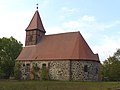
Category:Kirche Winkelstedt (Dähre)
| Object location | | View all coordinates using: OpenStreetMap |
|---|
 | |||||
| Upload media | |||||
| Instance of | |||||
|---|---|---|---|---|---|
| Location | Winkelstedt, Dähre, Altmarkkreis Salzwedel, Saxony-Anhalt, Germany | ||||
| Heritage designation | |||||
 | |||||
This is the category of the Saxony-Anhalt Kulturdenkmal (cultural heritage monument) with the ID 09405851 (Wikidata)
|
Media in category "Kirche Winkelstedt (Dähre)"
The following 6 files are in this category, out of 6 total.
-
 L1040662Winkelstedt.JPG 4,000 × 3,000; 6.02 MB
-
 L1040663str Winkelstedt.jpg 3,999 × 3,002; 8.23 MB
-
 L1040664Winkelstedt.JPG 4,000 × 3,000; 4.63 MB
-
 L1040665Winkelstedt.JPG 3,000 × 4,000; 6.63 MB
-
 L1040666Winkelstedt.JPG 3,000 × 4,000; 4.77 MB
-
 L1040667Winkelstedt.JPG 4,000 × 3,000; 6.78 MB


