Category:Kirchengasse 2 (Leutershausen)
| Object location | | View all coordinates using: OpenStreetMap |
|---|
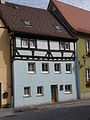
building in Leutershausen, Middle Franconia, Germany  | |||||
| Upload media | |||||
| Instance of | |||||
|---|---|---|---|---|---|
| Location | Leutershausen, Ansbach, Middle Franconia, Bavaria, Germany | ||||
| Street address |
| ||||
| Heritage designation | |||||
 | |||||
This is the category of the Bavarian Baudenkmal (cultural heritage monument) with the ID D-5-71-174-34 (Wikidata)
|
Media in category "Kirchengasse 2 (Leutershausen)"
The following 3 files are in this category, out of 3 total.
-
 Leutershausen Kirchengasse 2 001.jpg 2,448 × 3,264; 3.42 MB
-
 Leutershausen Kirchengasse 2 002.jpg 2,448 × 3,264; 3.68 MB
-
 Leutershausen, Kirchengasse 2-001.jpg 3,264 × 4,928; 8.87 MB

