Category:Kiveton Park
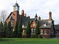
English: Kiveton Park, informally Kiveton or kivo(in either case, Kiveton is pronounced with three syllables, i.e. /ˈkɪ-və-ˌtən/), is a village within the Metropolitan Borough of Rotherham, in South Yorkshire, England. Historically a part of the West Riding of Yorkshire, from the Norman conquest to 1868, Kiveton was a hamlet of the parish of Harthill-with-Woodall. It subsequently transferred to the civil parish of Wales which takes its name from the neighbouring village.
Italiano: Kiveton Park, noto semplicemente come Kiveton, è un villaggio nel metropolitan borough of Rotherham.
Nederlands: Kiveton Park is een plaats in het bestuurlijke gebied Rotherham, in het Engelse graafschap South Yorkshire. De plaats telt inwoners.
village in the Metropolitan Borough of Rotherham in South Yorkshire, England, United Kingdom  | |||||
| Upload media | |||||
| Instance of | |||||
|---|---|---|---|---|---|
| Location | Wales, Rotherham, South Yorkshire, Yorkshire and the Humber, England | ||||
| Elevation above sea level |
| ||||
 | |||||
Subcategories
This category has the following 6 subcategories, out of 6 total.
Media in category "Kiveton Park"
The following 47 files are in this category, out of 47 total.
-
 40001 Kiveton Park Colliery.jpg 1,799 × 1,177; 330 KB
-

-
 Canal and Railway - geograph.org.uk - 128708.jpg 640 × 480; 118 KB
-

-
 Chesterfield Canal - Albert's Dock - geograph.org.uk - 1137332.jpg 640 × 480; 103 KB
-

-

-
 Cottages at Albert's Dock - geograph.org.uk - 1333859.jpg 480 × 640; 89 KB
-
 Kiveton - Hepworth.jpg 1,299 × 652; 94 KB
-
 Kiveton - Medics.jpg 4,031 × 2,013; 2.43 MB
-
 Kiveton - Medicsb.jpg 4,031 × 2,013; 1.52 MB
-
 Kiveton Gardens - panoramio - PJMarriott.jpg 3,072 × 2,304; 837 KB
-
 Kiveton Gardens - panoramio.jpg 3,072 × 2,304; 1.02 MB
-
 Kiveton Lane - panoramio - PJMarriott.jpg 3,072 × 2,304; 1.59 MB
-
 Kiveton Lane - panoramio.jpg 3,072 × 2,304; 1.36 MB
-
 Kiveton Park - Bus Stop on Red Hill - geograph.org.uk - 1137387.jpg 640 × 480; 63 KB
-
 Kiveton Park - Chesterfield Canal - geograph.org.uk - 1137312.jpg 640 × 480; 81 KB
-
 Kiveton Park - Chesterfield Canal - geograph.org.uk - 1137325.jpg 640 × 480; 107 KB
-

-
 Kiveton Park - colliery offices - geograph.org.uk - 1617190.jpg 640 × 480; 73 KB
-
 Kiveton Park - Crossroads - geograph.org.uk - 1137269.jpg 640 × 480; 61 KB
-
 Kiveton Park - geograph.org.uk - 2540.jpg 640 × 480; 57 KB
-

-

-
 Kiveton Park - Level Crossing - geograph.org.uk - 1137288.jpg 640 × 480; 70 KB
-

-
 Kiveton Park - steel works - geograph.org.uk - 1617187.jpg 640 × 480; 66 KB
-

-

-
 Kiveton Waters Fishery - geograph.org.uk - 575816.jpg 640 × 480; 123 KB
-
 KivetonHardLane.jpg 5,248 × 3,936; 5.4 MB
-
 KivetonHardLane2.jpg 5,248 × 3,936; 4.51 MB
-
 Moorings on the Chesterfield Canal - geograph.org.uk - 1780701.jpg 518 × 389; 165 KB
-

-
 Old road on Red Hill Kiveton Park - geograph.org.uk - 1293331.jpg 640 × 480; 64 KB
-
 Path over the summit - geograph.org.uk - 1780709.jpg 518 × 389; 153 KB
-

-
 Siding to Nowhere - geograph.org.uk - 196424.jpg 640 × 480; 92 KB
-
 The line to Sheffield - geograph.org.uk - 1589629.jpg 640 × 426; 109 KB
-
 Wales - Winding Wheel, Kiveton Park.jpg 640 × 480; 111 KB
-
 Wales Kiveton Methodist Church - geograph.org.uk - 930698.jpg 640 × 480; 75 KB
-
 WalesCricketGround.jpeg 4,032 × 2,432; 1.95 MB
-
 Angler's pitch, Chesterfield Canal - geograph.org.uk - 1780723.jpg 389 × 518; 149 KB
-

-
 Track to Harry Crofts - geograph.org.uk - 128705.jpg 640 × 480; 63 KB
-
 Wales Shopping - geograph.org.uk - 149225.jpg 640 × 480; 79 KB
-
 Wood on a Hill - geograph.org.uk - 122309.jpg 640 × 427; 63 KB


