Category:Kloster Münsterlingen
| Object location | | View all coordinates using: OpenStreetMap |
|---|
 | |||||
| Upload media | |||||
| Instance of |
| ||||
|---|---|---|---|---|---|
| Part of | |||||
| Location |
| ||||
| Street address |
| ||||
| Heritage designation |
| ||||
 | |||||
|
This is a category about a cultural property of national significance in Switzerland with KGS number 5120
|
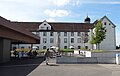
Deutsch: Das Kloster Münsterlingen war eine Benediktinerinnenabtei. 1848 wurde es durch den Kanton Thurgau aufgehoben. Seit 1840 dient die Anlage (oder zumindest Teile davon) als Kantonsspital.
English: Kloster Münsterlingen was a Benedictine convent. It was dissolved by the Canton of Thurgau in 1848. From 1840 onwards it has been used as a state hospital.
Subcategories
This category has the following 2 subcategories, out of 2 total.
R
- Maria Dorothea von Rost (10 F)
Media in category "Kloster Münsterlingen"
The following 37 files are in this category, out of 37 total.
-
 Kloster Münsterlingen 1854.tif 1,128 × 812; 1.56 MB
-
 Anna Gertrude Hofner, abbess of Münsterlingen.jpg 536 × 685; 59 KB
-
 Das neue Kloster Münsterlingen, Mitte des 19. Jahrhunderts.jpg 4,246 × 2,871; 4.14 MB
-
 MunsterlingenKloster.jpg 5,092 × 2,141; 6.53 MB
-
 Ehemaliges Kloster Münsterlingen - MG 0705.jpg 2,560 × 1,440; 3.38 MB
-
 ETH-BIB-Münsterlingen, Psychiatrische Klinik-LBS H1-017021.tif 6,528 × 4,551; 85.16 MB
-
 ETH-BIB-Münsterlingen, Scherzingen, Kreuzlingen, Blick von Südosten (SE)-LBS H1-017024.tif 6,535 × 4,571; 85.63 MB
-
 Muensterlingen.JPG 3,470 × 2,049; 5.88 MB
-
 MuensterlingenKirchturm.JPG 2,376 × 3,568; 5.17 MB
-
 MuensterlingenKlosterHof.JPG 2,376 × 3,568; 5.6 MB
-
 MuensterlingenKlosterhof1.jpg 7,343 × 4,516; 16.38 MB
-
 MuensterlingenKlosterHofTurm.JPG 3,568 × 2,376; 5.46 MB
-
 MuensterlingenKlosterHofTurm1.JPG 2,376 × 3,568; 5.75 MB
-
 MuensterlingenKlosterNord.JPG 3,568 × 2,376; 6.01 MB
-
 MuensterlingenKlosterNorden.JPG 2,376 × 3,568; 4.95 MB
-
 MuensterlingenKlosterNordost.JPG 3,568 × 2,376; 5.87 MB
-
 MuensterlingenKlosterOekonm.JPG 3,489 × 2,376; 6.04 MB
-
 MuensterlingenKlosterOekonomie.jpg 4,182 × 5,135; 9.62 MB
-
 MuensterlingenKlosterPortal.JPG 2,376 × 3,568; 5.39 MB
-
 MuensterlingenKlosterPortal1.jpg 3,517 × 4,994; 7.96 MB
-
 MuensterlingenKlosterStatuen.JPG 2,877 × 2,376; 4.77 MB
-
 MuensterlingenKlosterSued.JPG 2,376 × 3,568; 7.67 MB
-
 MuensterlingenKlosterSuedost.JPG 3,568 × 2,376; 5.75 MB
-
 MuensterlingenKlosterSuedwest.jpg 5,469 × 3,207; 13.5 MB
-
 MuensterlingenKlosterSüdost.JPG 2,272 × 3,568; 5.71 MB
-
 MuensterlingenFountain.JPG 3,033 × 2,240; 5.86 MB
-
 MuensterlingenKlosterWestBrunnen.jpg 4,936 × 3,707; 10.65 MB
-
 MuensterlingenKlosterWestBrunnen1.jpg 5,122 × 3,888; 10.44 MB
-
 MuensterlingenKlosterWestBrunnen2.jpg 3,888 × 5,184; 17.82 MB
-
 MuensterlngnAltesKloster.JPG 2,376 × 3,442; 7.36 MB
-
 MuensterlngnAltesKloster1.JPG 4,224 × 2,376; 7.43 MB
-
 MuensterlngnSee.JPG 4,224 × 2,376; 6.42 MB
-
 MuenstrlngnAltesKloster.JPG 3,114 × 2,376; 6.74 MB
-
 MuenstrlngnKloster.JPG 2,519 × 1,461; 2.23 MB
-
 MuenstrlngnKlosterS.JPG 3,349 × 2,376; 7.45 MB
-
 MuenstrlngnKlosterSued.jpg 4,555 × 2,934; 5.62 MB
-
 Spital01462.JPG 1,469 × 930; 753 KB


