Category:Koestraat 109, Schoonhoven
| Object location | | View all coordinates using: OpenStreetMap |
|---|
 | |||||
| Upload media | |||||
| Instance of | |||||
|---|---|---|---|---|---|
| Location | Schoonhoven, Krimpenerwaard, South Holland, Netherlands | ||||
| Street address |
| ||||
| Located on street | |||||
| Heritage designation |
| ||||
 | |||||
|
This is a category about rijksmonument number 33480
|
| Address |
|
Media in category "Koestraat 109, Schoonhoven"
The following 9 files are in this category, out of 9 total.
-
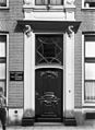 Ingang - Schoonhoven - 20198430 - RCE.jpg 875 × 1,200; 190 KB
-
 Interieur voorkamer - Schoonhoven - 20198428 - RCE.jpg 882 × 1,200; 184 KB
-
 Koestraat 109, voorgevel - Schoonhoven - 20198429 - RCE.jpg 873 × 1,200; 255 KB
-
 Koestraat 119, voorgevel - Schoonhoven - 20198426 - RCE.jpg 883 × 1,200; 176 KB
-
 Koestraat 119, voorgevel - Schoonhoven - 20198427 - RCE.jpg 881 × 1,200; 221 KB
-
 Overzicht van de voorgevel - Schoonhoven - 20384709 - RCE.jpg 1,194 × 1,200; 268 KB
-
 RM33480 Schoonhoven - Koestraat 109.jpg 1,944 × 2,592; 1.34 MB
-
 Voorgevels - Schoonhoven - 20198602 - RCE.jpg 1,200 × 1,200; 333 KB
-
 Voorgevels - Schoonhoven - 20198604 - RCE.jpg 1,200 × 806; 205 KB


