Category:Koestraat 95, Schoonhoven
| Object location | | View all coordinates using: OpenStreetMap |
|---|
building in Krimpenerwaard, Netherlands  | |||||
| Upload media | |||||
| Instance of | |||||
|---|---|---|---|---|---|
| Location | Schoonhoven, Krimpenerwaard, South Holland, Netherlands | ||||
| Street address |
| ||||
| Located on street | |||||
| Heritage designation |
| ||||
 | |||||
|
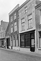
This is a category about rijksmonument number 33477
|
| Address |
|
Media in category "Koestraat 95, Schoonhoven"
The following 4 files are in this category, out of 4 total.
-
 Overzicht voorgevels - Schoonhoven - 20198594 - RCE.jpg 1,200 × 1,029; 263 KB
-
 RM33476 Schoonhoven - Koestraat 93.jpg 1,944 × 2,592; 1.18 MB
-
 RM33477 Schoonhoven - Koestraat 95.jpg 1,944 × 2,592; 1.3 MB
-
 Voorgevels - Schoonhoven - 20198596 - RCE.jpg 807 × 1,200; 199 KB


