Category:Korte Linschoten OZ 13, Linschoten
| Object location | | View all coordinates using: OpenStreetMap |
|---|
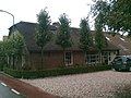
farmhouse in Montfoort, Netherlands  | |||||
| Upload media | |||||
| Instance of | |||||
|---|---|---|---|---|---|
| Location | Linschoten, Utrecht, Netherlands | ||||
| Street address |
| ||||
| Located on street |
| ||||
| Heritage designation |
| ||||
 | |||||
|
This is a category about rijksmonument number 25972
|
| Address |
|
Media in category "Korte Linschoten OZ 13, Linschoten"
The following 5 files are in this category, out of 5 total.
-
 25972-KLOZ13-0124.jpg 2,048 × 1,536; 781 KB
-
 Oost-zijde 13, voorgevel - Linschoten - 20140599 - RCE.jpg 1,200 × 959; 250 KB
-
 Oost-zijde 13, zijgevel - Linschoten - 20140600 - RCE.jpg 1,200 × 1,017; 241 KB
-
 Voorgevel - Linschoten - 20140601 - RCE.jpg 1,200 × 800; 248 KB
-
 Zijaanzicht - Linschoten - 20140602 - RCE.jpg 1,200 × 805; 256 KB


