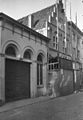
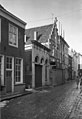
Category:Korte Putstraat 9, 's-Hertogenbosch
| Object location | | View all coordinates using: OpenStreetMap |
|---|
 | |||||
| Upload media | |||||
| Instance of |
| ||||
|---|---|---|---|---|---|
| Location | 's-Hertogenbosch, North Brabant, Netherlands | ||||
| Street address |
| ||||
| Located on street | |||||
| Heritage designation |
| ||||
 | |||||
|
This is a category about rijksmonument number 21687
|
| Address |
|
Media in category "Korte Putstraat 9, 's-Hertogenbosch"
The following 6 files are in this category, out of 6 total.
-
 's-Hertogenbosch Rijksmonument 21687 Korte Putstraat 1G tm 11.JPG 3,648 × 2,736; 3.13 MB
-
 Overzicht - 's-Hertogenbosch - 20110808 - RCE.jpg 827 × 1,200; 199 KB
-
 Overzicht - 's-Hertogenbosch - 20110809 - RCE.jpg 824 × 1,200; 196 KB
-
 Overzicht - 's-Hertogenbosch - 20110812 - RCE.jpg 788 × 1,200; 222 KB
-

-
 Voorgevel - 's-Hertogenbosch - 20110807 - RCE.jpg 953 × 1,200; 234 KB


_of_Den_Bosch,_with_only_restaurants_with_terraces_-_panoramio.jpg)
